This article needs additional citations for verification .(May 2024) |
Anibare | |
|---|---|
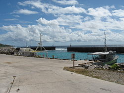 Anibare Harbour | |
 Anibare District within Nauru | |
| Coordinates: 0°31′50″S166°56′40″E / 0.53056°S 166.94444°E | |
| Country | |
| Constituency | Anabar |
| Area | |
• Total | 3.1 km2 (1.2 sq mi) |
| Elevation | 30 m (98 ft) |
| Population (2021) | |
• Total | 373 [1] |
| Time zone | (UTC+12) |
| Area code | +674 |
Anibare is a district in the island nation of Nauru, a part of the Anabar constituency. It is Nauru's largest district in area, and the smallest in population.