Zazafotsy is a town and commune in Madagascar. It belongs to the district of Ihosy, which is a part of Ihorombe Region. The population of the commune was 14,062 in 2018.
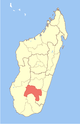
Ihorombe is a region in Madagascar. It borders Haute Matsiatra region in north, Atsimo-Atsinanana in east, Anosy in south and Atsimo-Andrefana in west. The capital is Ihosy and the population was 418,520 in 2018. The area of Ihorombe is 26,391 km2 (10,190 sq mi) and it has one of the lowest population densities of the Malagasy regions.
Andranofasika is a rural commune in Madagascar. It belongs to the district of Ambato-Boeni, which is a part of Boeny Region. The population of the commune was estimated to be 16,971 in 2018.
Tsiafajavona Ankaratra is a rural municipality in Madagascar. It belongs to the district of Ambatolampy, which is a part of Vakinankaratra Region. The population of the commune was estimated to be approximately 15,000 in 2001 commune census. It is situated at 12 km from Ambatolampy and 79 km from the capital Antananarivo.
Ambatolahy is a town and commune in Madagascar. It belongs to the district of Ihosy, which is a part of Ihorombe Region. The population of the commune was estimated to be approximately 10,000 in 2001 commune census.
Ambia is a town and commune in Madagascar. It belongs to the district of Ihosy, which is a part of Ihorombe Region. The population of the commune was estimated to be approximately 5,000 in 2001 commune census.
Analaliry is a rural municipality in Madagascar. It belongs to the district of Ihosy, which is a part of Ihorombe Region. The population of the commune was estimated to be approximately 5,000 in 2001 commune census.
Analavoka is a town and commune in Madagascar. It belongs to the district of Ihosy, which is a part of Ihorombe Region. The population of the commune was estimated to be approximately 5,000 in 2001 commune census.
Irina is a rural municipality in Madagascar. It belongs to the district of Ihosy, which is a part of Ihorombe Region. The population of the commune was estimated to be approximately 5,000 in 2001 commune census.
Sahambano is a town and commune in Madagascar. It belongs to the district of Ihosy, which is a part of Ihorombe Region. The population of the commune was estimated to be approximately 6,000 in the 2001 commune census.
Sakalalina is a municipality in Madagascar. It belongs to the district of Ihosy, which is a part of Ihorombe Region. The population of the commune was estimated to be approximately 7,000 in 2001 commune census.
Soamatasy is a rural municipality in Madagascar. It belongs to the district of Ihosy, which is a part of Ihorombe Region. The population of the commune was estimated to be approximately 3,000 in 2001 commune census.

Ihosy is a district in south-eastern Madagascar. It is a part of Ihorombe Region and borders the districts of Ikalamavony in north, Ambalavao in northeast, Ivohibe in east, Iakora in southeast, Betroka in south, Benenitra in southwest, Sakaraha and Ankazoabo Sud in west and Beroraha in the South West. The area is 17,358 km2 (6,702 sq mi) and the population was 292,880 in 2018.

Soatanana is a rural municipality in Madagascar. It belongs to the district of Fianarantsoa II, which is a part of Haute Matsiatra Region. The population of the commune was estimated to be approximately 10,000 in 2001 commune census.
Maropaika is a town and commune in Madagascar. It belongs to the district of Ivohibe, which is a part of Ihorombe Region. The population of the commune was estimated to be approximately 9,000 in 2001 commune census.
Behara is a town and commune in Madagascar. It belongs to the district of Amboasary Sud, which is a part of Anosy Region. The population of the commune was estimated to be approximately 27,285 in 2018.

Manambaro is a rural municipality in Madagascar. It belongs to the district of Taolanaro, which is a part of Anosy Region.
Ranopiso is a municipality in Madagascar. It belongs to the district of Taolanaro, which is a part of Anosy Region.
Tolohomiady is a rural municipality in Madagascar. It belongs to the district of Ihosy, which is a part of Ihorombe Region. The population of the commune was 3,768 in 2018.
Andohan'ilakaka is a commune in Madagascar. It belongs to the district of Ihosy, which is a part of Ihorombe Region. The population of the commune was 33,002 in 2018.