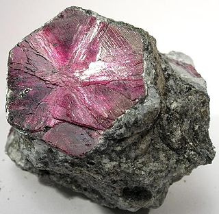
Ilakaka is a small town in Ihorombe Region in the south western part of Madagascar. In the early 1990s there were only about 40 residents in the area. After the discovery of one of Earth's largest known alluvial sapphire deposits in the valley of the Ilakaka river in 1998, the population had boomed to nearly 60,000 in 2005. Since high profits are at stake, violence is common in the town.

Ihosy[iˈusʲ] is a city with 283,047 inhabitants (2015) in Ihorombe Region in central south Madagascar.
Zazafotsy is a town and commune in Madagascar. It belongs to the district of Ihosy, which is a part of Ihorombe Region. The population of the commune was 14,062 in 2018.

The Ihosy River is a river in Fianarantsoa Province in central Madagascar. It runs down from the hills of Bekisopa, through the town of Ihosy, which provides the name of the river.

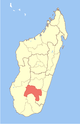
Ihorombe is a region in Madagascar. It borders Haute Matsiatra region in north, Atsimo-Atsinanana in east, Anosy in south and Atsimo-Andrefana in west. The capital is Ihosy and the population was 418,520 in 2018. The area of Ihorombe is 26,391 km2 (10,190 sq mi) and it has one of the lowest population densities of the Malagasy regions.

Ambatolahy is a town and commune in Madagascar. It belongs to the district of Ihosy, which is a part of Ihorombe Region. The population of the commune was estimated to be approximately 10,000 in 2001 commune census.
Ambia is a town and commune in Madagascar. It belongs to the district of Ihosy, which is a part of Ihorombe Region. The population of the commune was estimated to be approximately 5,000 in 2001 commune census.
Analaliry is a town and commune in Madagascar. It belongs to the district of Ihosy, which is a part of Ihorombe Region. The population of the commune was estimated to be approximately 5,000 in 2001 commune census.
Analavoka is a town and commune in Madagascar. It belongs to the district of Ihosy, which is a part of Ihorombe Region. The population of the commune was estimated to be approximately 5,000 in 2001 commune census.
Irina is a town and commune in Madagascar. It belongs to the district of Ihosy, which is a part of Ihorombe Region. The population of the commune was estimated to be approximately 5,000 in 2001 commune census.

Ranohira is a town and commune in Madagascar. It belongs to the district of Ihosy, which is a part of Ihorombe Region. The population of the commune was estimated to be approximately 6,000 in 2001 commune census.
Sahambano is a town and commune in Madagascar. It belongs to the district of Ihosy, which is a part of Ihorombe Region. The population of the commune was estimated to be approximately 6,000 in the 2001 commune census.
Soamatasy is a town and commune in Madagascar. It belongs to the district of Ihosy, which is a part of Ihorombe Region. The population of the commune was estimated to be approximately 3,000 in 2001 commune census.

Iakora District is a district in south-eastern Madagascar. It is a part of Ihorombe Region and borders the districts of Ihosy to the northwest, Ivohibe to the northeast, Midongy Sud to the east, Befotaka to the south and Betroka to the west. The area is 4,556.49 km2 (1,759 sq mi) and the population was estimated at 55,380 in 2018.

Ivohibe is a district in south-eastern Madagascar. It is a part of Ihorombe Region and borders the districts of Ambalavao in north, Vondrozo in east, Midongy Sud in south, Iakora in southwest and Ihosy in west. The area is 4,119 km2 (1,590 sq mi) and the population was estimated to be 34,289 in 2001.
Antambohobe is a town and commune in Madagascar. It belongs to the district of Ivohibe, which is a part of Ihorombe Region. The population of the commune was estimated to be approximately 9,000 in the 2001 commune census.
Maropaika is a town and commune in Madagascar. It belongs to the district of Ivohibe, which is a part of Ihorombe Region. The population of the commune was estimated to be approximately 9,000 in 2001 commune census.

Route nationale 7 (RN7) is a primary highway in Madagascar running 980km from the capital Antananarivo to Tulear at the south-west coast of the country. It crosses the regions of Analamanga, Vakinankaratra, Amoron'i Mania, Haute Matsiatra, Ihorombe, and Atsimo-Andrefana.
Tolohomiady is a commune in Madagascar. It belongs to the district of Ihosy, which is a part of Ihorombe Region. The population of the commune was 3,768 in 2018.
Andohan'ilakaka is a commune in Madagascar. It belongs to the district of Ihosy, which is a part of Ihorombe Region. The population of the commune was 33,002 in 2018.