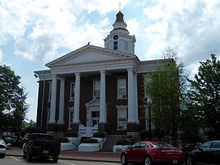
Logan County is a county located in the U.S. state of Arkansas. As of the 2020 census, the population was 21,131. Its two county seats are Booneville and Paris.

Arkansas Highway 27 is a designation for two north–south state highways in Arkansas. One route begins at US Highway 59 (US 59) and US 71 near Ben Lomond north to Highway 7 in Dardanelle. A second segment begins at Highway 7 in Dover and runs north to Highway 14 at Harriet. An original Arkansas state highway, Highway 27 was created as one continuous route in 1926, but was split around Russellville in 1961.
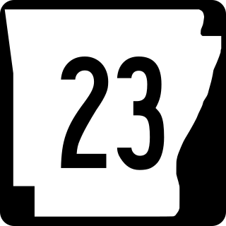
Arkansas Highway 23 is a north–south state highway in north Arkansas. The route runs 129.88 miles (209.02 km) from US 71 near Elm Park north to the Missouri state line through Ozark and Eureka Springs. Between AR 16 at Brashears and Interstate 40 north of Ozark, Highway 23 winds through the Ozark National Forest and is designated as the Pig Trail Scenic Byway due to its steep hills and hairpin turns. The route has a strong connection with the University of Arkansas Razorbacks, connecting fans in Central Arkansas with the Northwest Arkansas area.

Highway 22 is an east–west state highway in the Arkansas River Valley. It is maintained by the Arkansas State Highway and Transportation Department (AHTD). The highway runs 75.60 miles (121.67 km) from US 64/US 71B east to Highway 7 in Dardanelle. Following the historic stagecoach line of the cross-country Butterfield Trail, the highway is one of the original 1926 state highways. It is designated by the AHTD as the True Grit Trail.

Highway 41 is a designation for two state highways in Western Arkansas. One route of 18.02 miles (29.00 km) runs from Franklin County Route 40 (CR 40) south to Highway 23 near Chismville. A second routing begins at US Route 70B (US 70B) in De Queen and runs south to Texas State Highway 8 at the Texas state line. The northern segment of Highway 41 contains a 0.60 miles (0.97 km) officially designated exception over Highway 22 in Branch.

Arkansas Highway 10 is an east–west state highway in West Arkansas. The route runs 135.41 miles (217.92 km) from Oklahoma State Highway 120 near Hackett east to Interstate 30 in Little Rock, the state's capitol. The highway serves both the Fort Smith metropolitan area and the Little Rock – North Little Rock – Conway metropolitan area.

A total of ten special routes of U.S. Route 71 exist, and another ten previously existed.

Arkansas Highway 60 is a state highway that exists in five separate sections in Arkansas. The longest and most well-known segment of 54.19 miles (87.21 km) runs from Highway 28 in Plainview east to U.S. Route 65B (US 65B) in Conway. A segment in western Logan County of 2.64 miles (4.25 km) begins at the Old Highway 10 at the Sebastian County line and runs east to Highway 10. A third segment of 10.80 miles (17.38 km) begins at Highway 252 near Lavaca and runs east to Highway 41 at Peter Pender. A fourth segment runs 1.34 miles (2.16 km) from US 64 and runs across Interstate 40/Interstate 540 (I-40/I-540) to Highway 282. A fifth route of 2.34 miles (3.77 km) begins at Highway 282 near Rudy and runs north to County Road 23 (CR 23).

U.S. Highway 412 (US 412) runs east-to-west through northern Arkansas for about 290 miles (470 km). The route begins at the Oklahoma state line near Siloam Springs, and ends at the Missouri state line east of Paragould.

Arkansas Highway 119 is a series of state highways that run in Northeast Arkansas. All routes are maintained by the Arkansas Department of Transportation (ArDOT).

New Blaine is an unincorporated community and census-designated place (CDP) in Logan County, Arkansas, United States. Per the 2020 census, the population was 173.

Arkansas Highway 155 is a designation for four state highways in Arkansas. The northernmost segment of 7.10 miles (11.43 km) runs from Mount Nebo State Park to AR 22 in Dardanelle. A second segment in Yell County of 7.56 miles (12.17 km) connects Highway 7 and Highway 154. A third segment runs 11.16 miles (17.96 km) from AR 10 near Casa to Petit Jean State Park. The fourth segment is a 2.68-mile (4.31 km) spur from Highway 60 south to an area near Deberrie.

Highway 116 is a designation for two east–west state highways in Logan County. A northern route of 3.40 miles (5.47 km) runs east from Highway 23 encircling the northeastern quadrant of Booneville and ending at Highway 10. A second route of 1.02 miles (1.64 km) begins at Highway 23 and runs east to the Booneville Human Development Center.

Highway 284 is an east–west state highway in Arkansas Delta. The route of 34.83 miles (56.05 km) runs from U.S. Route 49 (US 49) near Fair Oaks east to Highway 1 Business (AR 1B) in Forrest City.
U.S. Highway 71 is a U.S. highway that runs from Krotz Springs, LA to the Fort Frances–International Falls International Bridge at the Canadian border. In Arkansas, the highway runs from the Louisiana state line near Doddridge to the Missouri state line near Bella Vista. In Texarkana, the highway runs along State Line Avenue with US 59 and partially runs in Texas. Other areas served by the highway include Fort Smith and Northwest Arkansas.

Arkansas Highway 174 is a designation for a state highway in Southwest Arkansas. The route is split into two sections. The first section begins at AR 355 in Spring Hill and ends at US Route 67 (US 67) in Hope. The second section begins at US 67 in Perrytown and ends at AR 299 just south of Interstate 30 (I-30). AR 174 is one of the few exceptions to the rule of an even-numbered state highway traveling north to south, rather than east to west.

Arkansas Highway 182 is the designation for a state highway in the U.S. state of Arkansas. The highway itself is split into two sections, both of which are mainly located in southwest Arkansas. The first section begins at U.S. Route 70 (US 70) just east of Welsh, and ends at AR 84 in Amity. The second section begins at AR 51 in Okolona, and ends at US 67 and AR 53 in Gurdon.

Arkansas Highway 185 is the designation for a state highway in the U.S. state of Arkansas. The route is split into three sections, which are all located in eastern Arkansas. The first section begins at AR 242 and ends at US Highway 49 Business (US 49B) in Helena-West Helena. The second section begins at US 49 near Wycamp, or just west of Helena-West Helena, and ends at AR 242 just north of Helena-West Helena. The third section begins at County Road 215 (CR 215) in Lee County and ends at AR 44 near Marianna.

Arkansas Highway 195 is the designation for a state highway in the U.S. state of Arkansas. The route is split into three sections, all of which are located in southwest Arkansas. The first section begins at AR 355 in Fulton, and ends at US 278 in Washington. The second section begins at AR 332 in De Ann, and ends at US 371 just east of Blevins. The third section begins at US 371 just east of McCaskill, and ends at AR 26 in Delight. All three routes are maintained by the Arkansas Department of Transportation (ARDOT).

Arkansas Highway 200 is the designation for a state highway in the U.S. state of Arkansas. The route is split into two sections, both of which are in southwest Arkansas. The first section begins at US 278 and US 371 in Rosston and ends at AR 299 at the unincorporated community of Morris. The second section begins at US 371 on the west end of Prescott and ends at AR 19 on the north end of Prescott. Both sections are located entirely within Nevada county and are maintained by the Arkansas Department of Transportation (ARDOT).

