Arkleton

Last updated

Arkleton
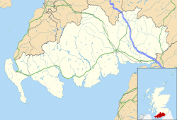
Dumfries and Galloway UK location map.svg
Red pog.svg
Arkleton
Location within Dumfries and Galloway
OS grid reference NY3791
Council area
Lieutenancy area
Country Scotland
Sovereign state United Kingdom
Post town LANGHOLM
Postcode district DG13
Dialling code 013873
Police Scotland
Fire Scottish
Ambulance Scottish
UK Parliament
Scottish Parliament
List of places
UK
Scotland
55°12′47″N2°58′37″W / 55.213°N 02.977°W / 55.213; -02.977 Coordinates: 55°12′47″N2°58′37″W / 55.213°N 02.977°W / 55.213; -02.977
Arkleton Steading with Arkleton House and Arkleton Hill behind Arkleton.jpg
Arkleton Steading with Arkleton House and Arkleton Hill behind

Arkleton is a mansion and estate in the civil parish of Ewes, in Dumfries and Galloway, Scotland.

Arkleton House was built in 1860/1884 and incorporates stone from Arkleton tower which stood nearby for 300 years until the early 19th Century. [1] It was the home of Dorothy and Walter Scott-Elliot who were murdered by their butler in 1977. The estate includes the 521m peak of Arkleton Hill which is part of the Langholm – Newcastleton Hills Site of Special Scientific Interest and Special Protection Area.

The Arkleton Trust was founded in 1977 “to study new approaches to rural development and education”. [2] It was named after Arkleton which was the home of its founder John Higgs and used for seminars in the early days of the charity. [3]
Related Research Articles

Balmoral Castle Royal residence

Balmoral Castle is a large estate house in Aberdeenshire, Scotland, owned by Queen Elizabeth II. It is near the village of Crathie, 9 miles west of Ballater and 50 miles west of Aberdeen.

National Trust Conservation organisation in England, Wales and Northern Ireland

The National Trust, formally the National Trust for Places of Historic Interest or Natural Beauty, is a charity and membership organisation for heritage conservation in England, Wales and Northern Ireland. In Scotland, there is a separate and independent National Trust for Scotland.

National Trust for Scotland Conservation charity that protects and promotes Scotlands natural and cultural heritage

The National Trust for Scotland for Places of Historic Interest or Natural Beauty, commonly known as the National Trust for Scotland, is a Scottish conservation organisation. It is the largest membership organisation in Scotland and describes itself as "the conservation charity that protects and promotes Scotland's natural and cultural heritage for present and future generations to enjoy".

Cuillin

The Cuillin is a range of rocky mountains located on the Isle of Skye in Scotland. The main Cuillin ridge is also known as the Black Cuillin to distinguish it from the Red Cuillin, which lie to the east of Glen Sligachan.

Knoydart Human settlement in Scotland

Knoydart is a peninsula in Lochaber, Highland, on the west coast of Scotland. Knoydart is sandwiched between Lochs Nevis and Hourn — often translated as "Loch Heaven" and "Loch Hell" respectively, although the somewhat poetic nature of these derivations is disputed. Forming the northern part of what is traditionally known as na Garbh-Chrìochan or "the Rough Bounds", because of its harsh terrain and remoteness, Knoydart is also referred to as "Britain's last wilderness". It is only accessible by boat, or by a 16-mile (26 km) walk through rough country, and the seven miles (11 km) of tarred road are not connected to the UK road system.

Cairngorms Mountain range in the eastern Highlands of Scotland

The Cairngorms are a mountain range in the eastern Highlands of Scotland closely associated with the mountain Cairn Gorm. The Cairngorms became part of Scotland's second national park on 1 September 2003. Although the Cairngorms give their name to, and are at the heart of, the Cairngorms National Park, they only form one part of the national park, alongside other hill ranges such as the Angus Glens and the Monadhliath, and lower areas like Strathspey.

Beinn Eighe Complex mountain massif in the Torridon area of Wester Ross in the Highlands of Scotland

Beinn Eighe is a complex mountain massif in the Torridon area of Wester Ross in the Highlands of Scotland. Lying to the south of Loch Maree, it forms a long ridge with many spurs and summits, two of which are classified as Munros. The name Beinn Eighe comes from the Scottish Gaelic meaning file mountain. Unlike most other hills in the area it has a cap of Cambrian basal quartzite which gives the peaks of Beinn Eighe a distinctive light colour. Its complex topography has made it popular with both hillwalkers and climbers and the national nature reserve on its northern side makes it an accessible mountain for all visitors.

Ben Lawers 1214m high mountain in Scotland

Ben Lawers is the highest mountain in the southern part of the Scottish Highlands. It lies to the north of Loch Tay, and is the highest point of a long ridge that includes seven Munros. It is the highest peak in Perthshire, and is the tenth highest Munro in Scotland. Ben Lawers was long thought to be over 4,000 feet (1,219.2 m) in height; accurate measurement in the 1870s showed it to be some 17 feet (5.2 m) short of this figure.

Wester Ross

Wester Ross is an area of the Northwest Highlands of Scotland in the council area of Highland. The area is loosely defined, and has never been used as a formal administrative region in its own right, but is generally regarded as lying to the west of the main watershed of Ross, thus forming the western half of the county of Ross and Cromarty. The southwesternmost part of Ross and Cromarty, Lochalsh, is not considered part of Wester Ross by the local tourist organisation, Visit Wester Ross, but is included within the definition used for the Wester Ross Biosphere Reserve.

Assynt Sparsely populated area of Sutherland on the west coast of Scotland

Assynt is a sparsely populated area in the south-west of Sutherland, lying north of Ullapool on the west coast of Scotland. Assynt is known for its landscape and its remarkable mountains, which have led to the area, along with neighbouring Coigach, being designated as the Assynt-Coigach National Scenic Area, one of 40 such areas in Scotland.

Glen Affric Valley in northern Scotland

Glen Affric is a glen south-west of the village of Cannich in the Highland region of Scotland, some 15 miles west of Loch Ness. The River Affric runs along its length, passing through Loch Affric and Loch Beinn a' Mheadhoin. A minor public road reaches as far as the end of Loch Beinn a' Mheadhoin, but beyond that point only rough tracks and footpaths continue along the glen.

Dunkeld Human settlement in Scotland

Dunkeld is a town in Perth and Kinross, Scotland. The location of a historic cathedral, it lies on the north bank of the River Tay, opposite Birnam. Dunkeld lies close to the geological Highland Boundary Fault, and is frequently described as the "Gateway to the Highlands" due to its position on the main road and rail lines north. Dunkeld has a railway station, Dunkeld & Birnam, on the Highland Main Line, and is about 25 kilometres north of Perth on what is now the A9 road. The main road formerly ran through the town, however following modernisation of this road it now passes to the west of Dunkeld.

Killerton House in Broadclyst, Exeter, Devon, England

Killerton is an 18th-century house in Broadclyst, Exeter, Devon, England, which, with its hillside garden and estate, has been owned by the National Trust since 1944 and is open to the public. The National Trust displays the house as a comfortable home. On display in the house is a collection of 18th- to 20th-century costumes, originally known as the Paulise de Bush collection, shown in period rooms.

Finzean Human settlement in Scotland

Finzean is a rural community, electoral polling district, community council area and former ecclesiastical parish, which forms the southern part of the Parish of Birse, Aberdeenshire, Scotland. Finzean was the subject of many well-known landscape paintings by the artist Joseph Farquharson, whose family have owned Finzean Estate since the 17th century. Finzean extends to approximately 8000 hectares in area and had a population of approximately 270 in 2002.

Walton and Ivythorn Hills Hills in Somerset, England

Walton and Ivythorn Hills is a 34.9 hectares biological Site of Special Scientific Interest near Street at the south-eastern end of the Polden Hills in the English county of Somerset. Walton Hill is south of the village of Walton, and Ivythorn Hill is south of Street. Notified in 1953, the site is now owned and managed by the National Trust who acquired the freehold in 1988.

Mar Lodge Estate

Mar Lodge Estate is a highland estate in western Aberdeenshire, Scotland, which has been owned and managed by the National Trust for Scotland (NTS) since 1995. Its principal building, Mar Lodge, is about 4 miles (6.4 km) west of the village of Braemar. The estate is recognised as one of the most important nature conservation landscapes in the British Isles and occupies nearly 8% of the Cairngorms National Park, covering 29,340 hectares. The natural heritage value of the estate is reflected by the fact that much of it is designated as a Site of Special Scientific Interest (SSSI), a Special Area of Conservation (SAC) and a Special Protection Area (SPA). The entire estate has been classified as a national nature reserve since May 2017, and is designated a Category II protected area by the International Union for Conservation of Nature.

Hill of Tarvit Mansion house and gardens in Fife, Scotland, UK

The Hill of Tarvit is a 20th-century mansion house and gardens in Fife, Scotland. They were designed by Sir Robert Lorimer and are today owned by the National Trust for Scotland.

Headley Down is a village within the civil parish of Headley in the East Hampshire district of Hampshire, England, bounded on two sides by Ludshott Common, a National Trust heathland reserve. The village began with a few buildings in the 1870s and became a thriving community that in the 20th century outgrew the parish centre of Headley.

Castlemilk House

Castlemilk House was a country house located in what is now the Castlemilk district of Glasgow, Scotland. The house was the ancestral home of the Stirling-Stuart family and was built around the 15th-century Cassiltoun Tower during the 18th and 19th centuries. The house and Castlemilk Estate were purchased by Glasgow Corporation in 1938, with the house serving as a children's home until it was closed in 1969 and demolished that year.

References

  1. "Arkleton from the Gazetteer for Scotland".
  2. "Welcome to the Arkleton Trust Website | the Arkleton Trust". Archived from the original on 9 January 2014. Retrieved 9 January 2014.
  3. "Dhl Email Virus - arkletontrust.com".
Farmland to the east of Arkleton Farmland to the east of Arkleton.jpg
Farmland to the east of Arkleton