
Hudson County is the smallest and most densely populated county in the U.S. state of New Jersey. It lies west of the lower Hudson River, which was named for Henry Hudson, the sea captain who explored the area in 1609. Part of New Jersey's Gateway Region in the New York metropolitan area, the county seat is Jersey City, which is the county's largest city in terms of both population and area. The county is part of the North Jersey region of the state.

Route 7 is a state highway in the northern part of New Jersey in the United States. It has two sections, an east–west alignment running from U.S. Route 1/9 Truck in Jersey City to Route 21 in Belleville, and a north–south alignment running from the Newark/Belleville to the Nutley/Clifton border. The New Jersey Department of Transportation (NJDOT) lists Route 7 as a single north–south highway with a small gap between the alignments. The entire highway has a combined length of 9.46 mi (15.22 km).

Kearny is a town in the western part of Hudson County, in the U.S. state of New Jersey, and a suburb of Newark. As of the 2020 United States census, the town's population was 41,999, an increase of 1,315 (+3.2%) from the 2010 census count of 40,684, which in turn reflected an increase of 171 (+0.4%) from the 40,513 counted in the 2000 census.

The Passaic River is a river, approximately 80 miles (130 km) long, in Northern New Jersey. The river in its upper course flows in a highly circuitous route, meandering through the swamp lowlands between the ridge hills of rural and suburban northern New Jersey, called the Great Swamp, draining much of the northern portion of the state through its tributaries.

County Route 508 is a county highway in the U.S. state of New Jersey. The highway extends 16.14 miles (25.97 km) from Mount Pleasant Avenue in Livingston to Belleville Turnpike in Kearny.
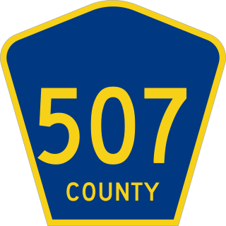
County Route 507 is a county highway in the U.S. state of New Jersey. The highway extends 28.37 mi (45.66 km) from Harrison Avenue on the Kearny-Harrison town line to the New York state line in Mahwah. Between Ho-Ho-Kus and Mahwah, this highway is known as Franklin Turnpike. At its northern terminus, County Route 507 continues north into New York as Orange Avenue, which is a portion of U.S. Route 202 (US 202).

The Passaic–Bergen–Hudson Transit Project is a project under study by NJ Transit to reintroduce passenger service on a portion of the New York, Susquehanna and Western Railway (NYSW) right-of-way (ROW) in Passaic, Bergen and Hudson counties using newly built, FRA-compliant diesel multiple unit rail cars. Plans call for service to run from Hawthorne south through Paterson, east to Hackensack and then southeast to North Bergen, where it would join the Hudson-Bergen Light Rail (HBLR).

South Kearny, also known as Kearny Point, is an industrial district and distinct area of the western part of Hudson County, New Jersey at the northern end of Newark Bay in the town of Kearny, New Jersey. It is on the larger peninsula once called New Barbadoes Neck, which also include the other Kearny districts of the Uplands and the Kearny Meadows. It has been known as Kearny Point and, along Droyer's Point in Jersey City, marks the mouth of the Hackensack River to the east. The Passaic River flows along its western border opposite a similarly industrial portion of the Ironbound district of Newark. Most of the point is part of Foreign-Trade Zone 49.

New Barbadoes Neck is the name given in the colonial era for the peninsula in northeastern New Jersey, US between the lower Hackensack and Passaic Rivers, in what is now western Hudson County and southern Bergen County. The neck begins in the south at Kearny Point in the Newark Bay and is characterized by a ridge along the west and part of the New Jersey Meadowlands on the east.

West Hudson is the western part of Hudson County, New Jersey comprising the contiguous municipalities of Kearny, Harrison and East Newark, which lies on the peninsula between the Hackensack River and Passaic River.
The Uplands district of Kearny, New Jersey is the residential area in the northwestern portion of town, on a ridge between the Kearny Meadows and the Passaic River, along which runs Riverbank Park. Arlington is located within the Kearny Uplands.

Riverbend is the name of two sections of Hudson County, New Jersey.
Riverbank Park is a park in the Ironbound section of Newark, Essex County, New Jersey, United States. The park was opened in 1910 and was added to the National Register of Historic Places on April 16, 1998. It is the smallest and one of the most heavily used parks in the Essex County Park System.

The Newark and New York Railroad was a passenger rail line that ran between Downtown Newark and the Communipaw Terminal at the mouth of the North River in Jersey City, bridging the Hackensack River and Passaic River just north of their mouths at the Newark Bay in northeastern New Jersey. The Central Railroad of New Jersey operated it from its opening in 1869. Though operations ended in 1946; portions remained in use until 1967.

West Arlington was a former commuter railroad train station in the Arlington section of Kearny, Hudson County, New Jersey. Located overlooking Passaic Avenue, West Arlington station was one of two in Kearny on the Erie Railroad's New York and Greenwood Lake Railroad, the other one being Arlington at Garafola Place. The station contained two low-level side platforms, with a pair of depots, one of which was on each platform. Trains went from Pavonia Terminal in Jersey City to Wanaque–Midvale station in Wanaque. The next station to the west was North Newark, across nearby WR Draw, a swing bridge over the Route 21, the Passaic River and Passaic Avenue.

Arlington Memorial Park is a cemetery located mostly within the Arlington section of Kearny in Hudson County, New Jersey, on Schuyler Avenue.

Kearny Riverbank Park is a municipal linear park along the Passaic River in Kearny, New Jersey. It is located in the Kearny Uplands north of Bergen Avenue and was extended to Belleville Turnpike in 2011 with brownfield reclamation projects. In 2012 improvements to the park's greenway were funded with a $1.8 million appropriation from the state.

WR Draw is an out-of-service railroad bridge crossing the Passaic River between Newark and the Arlington section of Kearny, New Jersey. The plate girder rim-bearing swing bridge, originally built in 1897 and modified in 1911 and 1950, is the 14th bridge from the river's mouth at Newark Bay and is 8.1 miles (13.0 km) upstream from it. Last used for regular passenger service in 2002, it is welded in closed position as its height is not considered a hazard to navigation.

The Belleville Turnpike Bridge is a vehicular moveable bridge spanning the Passaic River in northeastern New Jersey 8.9 miles (14.3 km) from its river mouth at Newark Bay. Also known as Rutgers Street Bridge and Route 7 Bridge, it is the fourth fixed crossing to be built at the location, today the tripoint of the municipal and county lines of Belleville in Essex, Kearny in Hudson, and North Arlington in Bergen. Commissioned by the New Jersey Department of Transportation, which owns and operates it, the vertical lift bridge opened in 2002.

The Essex–Hudson Greenway is planned state park and greenway in the northerneastern New Jersey counties of Essex and Hudson. It will follow an abandoned railroad right of way (ROW) across the New Jersey Meadowlands, over the Hackensack and Passaic rivers, as well pass through densely-populated neighborhoods. The nearly 9-mile (14 km) long shared-use linear park/rail trail will encompass about 135 acres (55 ha) and will average 100 feet (30 m) in width. Running between Jersey City and Montclair it will pass through Secaucus, Arlington in northern Kearny, North Newark, Belleville, Bloomfield and Glen Ridge. The initial phase in Newark and Kearny is expected to open in late 2025

