The regions of Niger are subdivided into 63 departments. Before the devolution program on 1999–2005, these departments were styled arrondissements. Confusingly, the next level up (regions) had, before 2002-2005 been styled departments. Prior to a revision in 2011, there had been 36 departments. Until 2010, arrondissements remained a proposed subdivision of departments, though none were used. The decentralisation process, begun in the 1995-1999 period replaced appointed Prefects at Departmental or Arrondissement level with elected councils, first elected in 1999. These were the first local elections held in the history of Niger. Officials elected at commune level are then selected as representatives at Departmental, regional, and National level councils and administration. The Ministry of Decentralisation was created to oversee this task, and to create a national consultative council of local officials.
Arlit is an industrial town and capital of the Arlit Department of the Agadez Region of northern-central Niger, built between the Sahara Desert and the eastern edge of the Aïr Mountains. It is 200 kilometers south by road from the border with Algeria. As of 2012, the commune had a total population of 79,725 people.
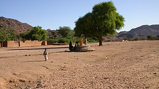
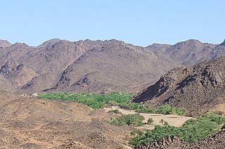
Timia is a small town and commune in northern Niger, situated at an oasis in the Aïr Mountains, Agadez Region, Arlit Department. Visitors come to the Tuareg town to see a seasonal waterfall, a former French fort and the nearby ruined town of Assodé. As of 2012, the commune had a total population of 19,076 people.

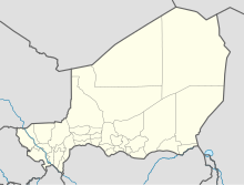
Agadez Region is one of the seven regions of Niger. At 667,799 square kilometres (257,839 sq mi), it covers more than half of Niger's land area, and is the largest region in the country, as well as the largest African state subdivision. The capital of the department is Agadez.
Orano Cycle, formerly COGEMA and Areva NC, is a French nuclear fuel company. It is the main subsidiary of Orano S.A. It is an industrial group active in all stages of the uranium fuel cycle, including uranium mining, conversion, enrichment, spent fuel reprocessing, and recycling.

In Guezzam is a town and commune that is the capital of In Guezzam Province, Algeria, on the border with Niger. Until 26 November 2019, it was a part of the Tamanrasset Province. The border town on the Niger side is Assamaka. According to the 2008 census it had a population of 7,045, up from 4,938 in 1998, with an annual growth rate of 3.7%, the second highest in the Tamanrasset province's 2008 boundaries.

Iferouane, also spelled Iferouan, is an oasis town and commune in northern Niger, in Agadez Department. It is located northeast of Arlit in the northern Aïr, in the Ighazar valley near the Tamgak Range.

Niger–United States relations are bilateral relations between Niger and the United States. The two countries cooperate on a range of issues, including counter-terrorism, trade and investment, and health and education. On August 4, 2023, Abdourahamane Tchiani's military junta severed diplomatic ties with the US after a successful coup d'état deposing Nigerien president Mohamed Bazoum. In 2024, the Niger ended its security cooperation with the United States, stating that the security pact violated the Niger's constitution.
Arlit is a department of the Agadez Region in Niger. Its capital lies at the city of Arlit. As of 2012, the department had a total population of 105,025 people.
Goûgaram is a town and commune in the Arlit Department of the Agadez Region of northern-central Niger. As of 2012, the commune had a population of 10,336.
Tchirozerine is a town and urban commune in Niger. As of 2012, the commune's population was 63,503.
Akokan is a mining town in the Arlit Department of the Agadez Region of northern-central Niger. It is located about 5 kilometres (3.1 mi) southwest of Arlit in the Sahara Desert, and roughly 250 kilometres (160 mi) north of Agadez. It is considered to be Niger's "second uranium town". SOMAIR and COMINAK, run by Areva and the Nigerien state, operate uranium mines in the vicinity of the towns of Akokan and Arlit. In the maps of the area, Akokan is classified under "Mine - Agadez-Niger". The Tuareg and Toubou people are local to the area.
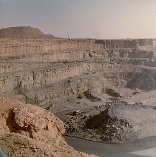
The Arlit mine is a large mine located near Arlit, in the northern part of Niger in Agadez Region. Arlit represents one of the largest uranium reserves in Niger having estimated reserves of 47.5 million tonnes of ore grading 0.014% uranium.
The 2016–17 Ligue 1 season is the top level of football competition in Niger. It began on 4 December 2016 and concluded on 25 June 2017.
The 2018 Coupe nationale du Niger is the 43rd edition of the Coupe nationale du Niger, the knockout football competition of Niger.
The 2018–19 Super Ligue is the 49nd season of the Super Ligue, the top-tier football league in Niger. The season started on 28 December 2018.

Idrissou Mora-Kpai, is a Beninese-American filmmaker. He is most notable as the director of critically acclaimed films Indochina Traces of a Mother, Arlit The Second Paris, and Si-Gueriki The Queen Mother. He is a recipient of the John Simon Guggenheim Memorial Foundation Fellowship and the Dutch Prince Claus Award