Related Research Articles

Bamako is the capital and largest city of Mali, with a 2022 population of 4,227,569. It is located on the Niger River, near the rapids that divide the upper and middle Niger valleys in the southwestern part of the country.

The Mid-Atlantic Ridge is a mid-ocean ridge located along the floor of the Atlantic Ocean, and part of the longest mountain range in the world. In the North Atlantic, the ridge separates the North American from the Eurasian Plate and the African Plate, north and south of the Azores Triple Junction. In the South Atlantic, it separates the African and South American plates. The ridge extends from a junction with the Gakkel Ridge northeast of Greenland southward to the Bouvet Triple Junction in the South Atlantic. Although the Mid-Atlantic Ridge is mostly an underwater feature, portions of it have enough elevation to extend above sea level, for example in Iceland. The ridge has an average spreading rate of about 2.5 centimetres (1 in) per year.

The Bureau of Enquiry and Analysis for Civil Aviation Safety is an agency of the French government, responsible for investigating aviation accidents and incidents and making safety recommendations based on what is learned from those investigations.
Diffa is a city and Urban Commune in the extreme southeast of Niger, near the border with Nigeria. It is the administrative seat of both Diffa Region, and the smaller Diffa Department. As of 2012, the commune had a total population of 56,437 people.
The W National Park or W Regional Park is a major national park in West Africa around a meander in the Niger River shaped like the letter W. The park includes areas of the three countries Niger, Benin and Burkina Faso, and is governed by the three governments. Until 2008, the implementation of a regional management was supported by the EU-funded project ECOPAS. The three national parks operate under the name W Transborder Park. The section of W National Park lying in Benin, measuring over 8,000 km2 (3,100 sq mi), came under the full management of African Parks in June 2020. In Benin, W National Park is contiguous with Pendjari National Park which is also under the management of African Parks.

Diori Hamani International Airport is an airport in Niamey, the capital of Niger. It is located 9 km (5.6 mi) from Niamey in the south-eastern suburbs of the city, along the Route Nationale 1, the major highway linking Niamey with the east of the nation. The airport complex also includes the major base for the Armed Forces of Niger's "Armee d'Air".

Veleta or Pico del Veleta is the third highest peak of the Iberian Peninsula and the second highest of the Sierra Nevada. Its height is given variously as 3,394 metres (11,135 ft), 3,396 metres (11,142 ft) and 3,398 metres (11,148 ft).
Goure Airport is an airport serving the Commune and town of Goure in Zinder Region of southeastern Niger.
Tessaoua Airport is an airport serving Tessaoua in Niger.
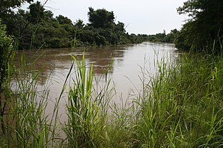
La Tapoa is a town on the Niger River in the Tillabéri Region of south-western Niger.

The Airport of the Golfe of Saint Tropez is an airport located in La Môle, 15 km (8 NM) southwest of Saint-Tropez, in the Var department of the Provence-Alpes-Côte d'Azur region in southeastern France.
Abala, Niger is a village and rural commune in Niger.
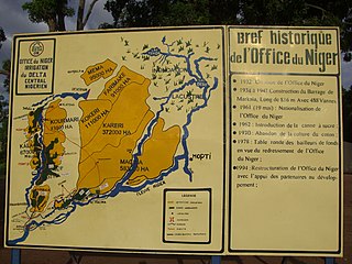
The Office du Niger is a semi-autonomous government agency in Mali that administers a large irrigation scheme in the Ségou Region of the country. Water from the Niger River is diverted into a system of canals at the Markala dam 35 kilometres (22 mi) downstream of Ségou. The water is used to irrigate nearly 100,000 hectares (390 sq mi) of the flat alluvial plains to the north and northeast of Markala that form part of the Delta mort. Although the French colonial administration constructed the system to produce cotton for the textile industry, the main agricultural product is now rice. Around 320,000 tons are grown each year representing 40 percent of the total Malian production. Large quantities of sugar cane are also grown in joint ventures between a Chinese company and the Malian state. The irrigation scheme uses 2.7 km3 (0.65 cu mi) of water each year corresponding to around 10 percent of the total flow of the Niger River.
Tanout Airport is an airport serving Tanout in Zinder Region of southern Niger. It is 15 kilometres (9.3 mi) west of the city centre, and its runway is 950 metres (3,120 ft) by 45 metres (148 ft).

The Gier is a French river that flows in a northeast direction through the Loire and Rhône departments. It is a tributary of the Rhône, which it enters from the right bank. The Gier valley was formerly heavily industrialized with coal and iron mines and factories.
Niger has a long history of petroleum exploration dating back to the 1970s. However, it is only since 2011 with the opening of the Agadem oilfield and the Soraz refinery near Zinder that petroleum is being produced in Niger. The oil and gas extracted from the Agadem field are processed at the Soraz refinery. The refined products are primarily for domestic consumption. Since the beginning of oil extraction, it appears that the reserves have been underestimated: from an estimate of 324 million barrel reserves in 2008, it is believed that reserves are three times higher, near 1 billion barrels in 2013.
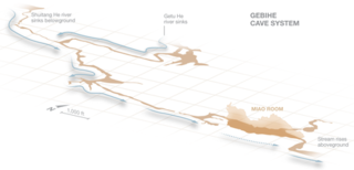
Miao Room is the largest known cave chamber by volume in the world. It is a part of the Gebihe cave system, which is located in Ziyun Getu He National Park in Ziyun county of the Chinese province of Guizhou. The chamber, discovered by a French expedition called Gebihe'89 in 1989, measures 852 metres (2,795 ft) in length, 191 metres (627 ft) in width, has an area of 154,500 square metres (1,663,000 sq ft), and a volume of 10,780,000 cubic metres (381,000,000 cu ft). In 2013, members of a British led expedition measured the chamber using 3-D laser scanners.

Botou is a department or commune of Tapoa Province in eastern Burkina Faso. Its capital is the town of Botou. The department constitutes a panhandle that stretches into Niger.
References
- ↑ "Attributions des départements de l'ANAC Archived 2013-06-04 at archive.today ." Agence nationale de l'aviation civile du Niger. Retrieved on 4 June 2013. "La Tapoa : dimensions de la piste = 1 200 x 25 m ; distance 3 km du Campement"
12°28′59″N2°24′00″E / 12.48300°N 2.40000°E
| | This article about an airport in Niger is a stub. You can help Wikipedia by expanding it. |