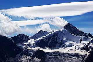
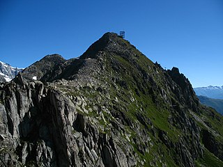
Aroser Weisshorn

Last updated
Aroser Weisshorn
Arosa-Weisshorn-01.jpg
Highest point
Elevation 2,653 m (8,704 ft)
Prominence 286 m (938 ft) [1]
Isolation 3.6 kilometres (2.2 mi)
Parent peak Aroser Rothorn
Coordinates 46°47′22.5″N09°38′17.6″E / 46.789583°N 9.638222°E / 46.789583; 9.638222 Coordinates: 46°47′22.5″N09°38′17.6″E / 46.789583°N 9.638222°E / 46.789583; 9.638222
Geography
Switzerland relief location map.jpg
Red triangle with thick white border.svg
Aroser Weisshorn
Location in Switzerland
Location Graubünden, Switzerland
Parent range Plessur Alps
Climbing
Easiest route Aerial tramway from Arosa
The top station of the cable car, near the summit Arosa Weishorn Top Station.jpg
The top station of the cable car, near the summit
Arosa seen from the top station Arosa-Weisshorn Bahn 09.JPG
Arosa seen from the top station

The Aroser Weisshorn is a mountain of the Plessur Alps, overlooking Arosa in the canton of Graubünden.

Mountain A large landform that rises fairly steeply above the surrounding land over a limited area

A mountain is a large landform that rises above the surrounding land in a limited area, usually in the form of a peak. A mountain is generally steeper than a hill. Mountains are formed through tectonic forces or volcanism. These forces can locally raise the surface of the earth. Mountains erode slowly through the action of rivers, weather conditions, and glaciers. A few mountains are isolated summits, but most occur in huge mountain ranges.

Plessur Alps mountain range

The Plessur Alps are a mountain range in the Alps of eastern Switzerland. They are considered to be part of the Western Rhaetian Alps. They are named after the river Plessur, which originates from the center of the ranges. The Plessur Alps are separated from the Glarus Alps in the west by the Rhine valley; from the Rätikon range in the north by the Landquart river valley (Prättigau); from the Albula Alps in the south-east by the Landwasser river valley; from the Oberhalbstein Alps in the south by the Albula river valley.

Arosa Place in Graubünden, Switzerland

Arosa is a statistic town and a municipality in the Plessur Region in the canton of Graubünden in Switzerland. It is both a summer and a winter tourist resort.

Contents

A two-stage cable car links the top of the mountain with the town and resort of Arosa — the base station is near to Arosa railway station.

Aerial lift Cable transport in which passenger containers are hauled above the ground by means of one or more cables

An aerial lift (US), also known as a cable car, is a means of cable transport in which cabins, cars, gondolas or open chairs are hauled above the ground by means of one or more cables. Aerial lift systems are frequently employed in mountainous territory where roads are relatively difficult to build and use, and have seen extensive use in mining. Aerial lift systems are relatively easy to move, and are and have been used to cross rivers and ravines. In more recent times, the cost-effectiveness and flexibility of aerial lifts has seen an increase of gondola lift being integrated into urban public transport systems.

Arosa (Rhaetian Railway station) railway station

Arosa is a railway station on the Chur-Arosa line of the Rhaetian Railway (RhB). It is situated in the town and resort of Arosa, close by to the Obersee.

See also

Related Research Articles

Rhaetian Railway Swiss transport company

The Rhaetian Railway, abbreviated RhB, is a Swiss transport company that owns the largest network of all private railway operators in Switzerland. The RhB operates all the railway lines of the Swiss canton of Graubünden/Grisons, except for the line from Sargans to the cantonal capital, Chur, which are operated by the Swiss Federal Railways (SBB CFF FFS), and the line from Disentis/Mustér to the Oberalp Pass, and further on to Andermatt, Uri, which is operated by Matterhorn Gotthard Bahn (MGB). Inaugurated in 1888 and expanded from 1896 onwards in various sections, the RhB network is located almost entirely within Graubünden, with one station across the Italian border at Tirano.

Lenzerheide village in Switzerland

Lenzerheide is a mountain resort in the canton of Graubünden, Switzerland at the foot of the Parpaner Rothorn. The village lies in the municipality Vaz/Obervaz in the district of Albula, sub-district Alvaschein.

Zinalrothorn mountain in the Pennine Alps

The Zinalrothorn is a mountain in the Pennine Alps in Switzerland. Its name comes from the village of Zinal lying on the north side and from the German word Rothorn which means Red Peak. When it was first climbed in 1864 the mountain was known locally as Moming.

Gornergrat mountain

The Gornergrat is a rocky ridge of the Pennine Alps, overlooking the Gorner Glacier south-east of Zermatt in Switzerland. It can be reached from Zermatt by the Gornergrat rack railway (GGB), the highest open-air railway in Europe. Between the Gornergrat railway station and the summit is the Kulm Hotel hosting the new Project "Stellarium Gornergrat" and until 2010 the Kölner Observatorium für SubMillimeter Astronomie KOSMA and before that the Gornergrat Infrared Telescope.

Obersee (Arosa) lake in the municipality Arosa, Graubünden, Switzerland

Obersee or Oberer Arosasee is the lake in the center of Arosa, a resort in the Grisons, Switzerland. The lake has a surface area of 7.1 ha at an elevation of 1734 m. Arosa's lower lake (Untersee) is at 1691 m.

Weisshorn mountain in the Pennine Alps

The Weisshorn is a major peak of the Swiss Alps, culminating at 4,506 metres above sea level. It is part of the Pennine Alps and is located between the valleys of Anniviers and Zermatt in the canton of Valais. In the latter valley, the Weisshorn is one of the many 4000ers surrounding Zermatt, with Monte Rosa and the Matterhorn.

Bettmerhorn Mountain in the Bernese Alps, Switzerland

The Bettmerhorn is a mountain of the Bernese Alps, located north of Bettmeralp in the Swiss canton of Valais. The summit can be reached with a 30-minute vertical hike after ascending most of the mountain by cable car from the car free village of Bettmeralp. Bettmeralp is accessible by cable car from the Betten train station.

Eggishorn mountain

The Eggishorn is a mountain of the Bernese Alps, located north of Fiesch in the Swiss canton of Valais. A cable car station is located on a secondary summit named Fiescherhorli, 500 metres south of the main peak.

Brunegghorn mountain

The Brunegghorn is a mountain of the Pennine Alps, overlooking the Mattertal in the canton of Valais. It is part of the Weisshorn group. On the west side of the mountain flows the Brunegg Glacier.

Aroser Rothorn mountain

The Aroser Rothorn is the highest mountain of the Plessur Alps. It is located between Arosa and Lenzerheide in the canton of Graubünden and with a summit elevation of 2,980 metres above sea level. The summit lies near the Parpaner Rothorn, which is served by a cable car.

Älpliseehorn mountain in Switzerland

The Älpliseehorn is a mountain of the Plessur Alps, located south of Arosa in Graubünden. It is part of the range east of the Aroser Rothorn. On the north side of the mountain lies the Älplisee.

Tschuggen mountain

The Tschuggen is a mountain of the Plessur Alps, overlooking Arosa in the Swiss canton of Graubünden.

The Weisshorn is a mountain located in the Pennine Alps. It is also the name of several other mountains:

Chur railway station Swiss railway station

Chur railway station serves the city of Chur, capital of the Canton of Graubünden, Switzerland. Opened in 1858, it is the most important railway junction in Graubünden.

Chur Altstadt (Rhaetian Railway station) railway station

Chur Stadt is a small railway station on the Chur-Arosa line of the Rhaetian Railway (RhB). It is situated near the old town (Altstadt) of Chur, on Plessurquai by the Plessur river, less than a kilometre (0.76 km) from the main railway station of the city.

Gründjitobel Viaduct arch bridge

The Gründjitobel Viaduct is a single track reinforced concrete railway bridge, spanning the Gründjitobelbach near Langwies, in the Canton of Graubünden, Switzerland.

Arosa Lenzerheide Ski area in Switzerland

Arosa Lenzerheide is a ski area located in Arosa, Lenzerheide, Valbella, Parpan and Churwalden, Graubünden/Switzerland. It originated 2013/14 by connecting the existing ski areas of Arosa and Lenzerheide. With a total of 225 kilometers of ski slopes and 41 cable cars it is the largest contiguous ski area in Graubünden.

References