Plessur Alps

Last updated
Plessur Alps
Arosa weisshorn 14 08 06.JPG
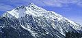
Aroser Weisshorn (2,653m/8,704ft)
Highest point
Peak Aroser Rothorn
Elevation 2,980.2 m (9,778 ft)
Coordinates 46°44'16"N, 9°36'50"E
Naming
Native namePlessuralpen (German)
Geography
Karte Plessur-Alpen.png
Plessur Alps
The borders of the range according to
Alpine Club classification of the Eastern Alps
CountrySwitzerland
State Graubünden
Parent range Western Rhaetian Alps
Topo map Swiss Federal Office of Topography swisstopo

The Plessur Alps are a mountain range in the Alps of eastern Switzerland and are considered to be part of the Western Rhaetian Alps. They are named after the river Plessur, which originates from the center of the ranges. The Plessur Alps are separated from the Glarus Alps in the west by the Rhine valley; from the Rätikon range in the north by the Landquart river valley (Prättigau); from the Albula Alps in the south-east by the Landwasser river valley; from the Oberhalbstein Alps in the south by the Albula river valley.

Contents

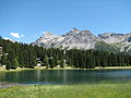
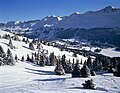
The Plessur Alps are drained by the rivers Rhine, Plessur, Landwasser and Landquart. The Arosa ski resort lies in the middle of the range.

Peaks of the Plessur Alps are the Aroser Rothorn (highest, 2,980 m (9,780 ft)) and Stätzerhorn (2,576 m (8,451 ft)).

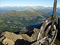
The 2,377-metre (7,799 ft) Strela Pass is one of the major mountain passes in the range, and runs from Davos to Langwies.

Peaks

The chief peaks of the Plessur Alps are listed below.

Mountain / PeakElevationProminenceCoordinates
mftmft
Aroser Rothorn 2,9809,7801,3494,426 46°44′16″N9°36′50″E / 46.73778°N 9.61389°E / 46.73778; 9.61389
Lenzerhorn 2,9069,534291955 46°42′32.51″N9°35′42.29″E / 46.7090306°N 9.5950806°E / 46.7090306; 9.5950806
Parpaner Rothorn 2,8999,51170230 46°44′33″N9°35′50″E / 46.74250°N 9.59722°E / 46.74250; 9.59722
Amselflue 2,7819,124290950 46°45′50″N9°43′44″E / 46.76389°N 9.72889°E / 46.76389; 9.72889
Sandhubel 2,7649,068117384 46°44′24″N9°41′5″E / 46.74000°N 9.68472°E / 46.74000; 9.68472
Valbellahorn 2,7649,068209686 46°44′23″N9°42′7″E / 46.73972°N 9.70194°E / 46.73972; 9.70194
Guggernell 2,7449,00364210 46°43′21″N9°39′12″E / 46.72250°N 9.65333°E / 46.72250; 9.65333
Älpliseehorn 2,7258,94094308 46°44′50″N9°38′51″E / 46.74722°N 9.64750°E / 46.74722; 9.64750
Schiahorn 2,7098,888113371 46°49′4″N9°48′14″E / 46.81778°N 9.80389°E / 46.81778; 9.80389
Aroser Weisshorn 2,6538,704286938 46°47′22″N9°38′18″E / 46.78944°N 9.63833°E / 46.78944; 9.63833
Strela 2,6368,64855180 46°48′32″N9°46′49″E / 46.80889°N 9.78028°E / 46.80889; 9.78028
Stelli 2,6228,602101331 46°50′10″N9°45′56″E / 46.83611°N 9.76556°E / 46.83611; 9.76556
Stätzerhorn 2,5748,4451,0283,373 46°45′49″N9°30′29″E / 46.76361°N 9.50806°E / 46.76361; 9.50806
Casanna 2,5578,389122400 46°51′33″N9°49′35″E / 46.85917°N 9.82639°E / 46.85917; 9.82639
Fulhorn 2,5298,297128420 46°46′26″N9°29′38″E / 46.77389°N 9.49389°E / 46.77389; 9.49389
Mattjisch Horn 2,4618,074171561 46°51′5″N9°43′24″E / 46.85139°N 9.72333°E / 46.85139; 9.72333
Gürgaletsch 2,4418,009144472 46°47′49.9″N9°34′57.4″E / 46.797194°N 9.582611°E / 46.797194; 9.582611
Cunggel 2,4137,917124407 46°51′57″N9°40′14″E / 46.86583°N 9.67056°E / 46.86583; 9.67056
Ful Berg 2,3957,85878256 46°52′17″N9°36′40″E / 46.87139°N 9.61111°E / 46.87139; 9.61111
Glattwang 2,3767,79554177 46°52′52″N9°42′52″E / 46.88111°N 9.71444°E / 46.88111; 9.71444

References