
The Rhine is one of the major European rivers. The river begins in the Swiss canton of Graubünden in the southeastern Swiss Alps. It forms the Swiss-Liechtenstein border and partly the Swiss-Austrian and Swiss-German borders. After that the Rhine defines much of the Franco-German border, after which it flows in a mostly northerly direction through the German Rhineland. Finally in Germany, the Rhine turns into a predominantly westerly direction and flows into the Netherlands where it eventually empties into the North Sea. It drains an area of 9,973 km2.

The geography of Switzerland features a mountainous and landlocked country located in Western and Central Europe. Switzerland's natural landscape is marked by its numerous lakes and mountains. It is surrounded by five countries: Austria and Liechtenstein to the east, France to the west, Italy to the south and Germany to the north. Switzerland has a maximum north–south length of 220 kilometres (140 mi) and an east–west length of about 350 kilometres (220 mi).

The Grisons or Graubünden, more formally the Canton of the Grisons or the Canton of Graubünden, is one of the twenty-six cantons of Switzerland. It has eleven districts, and its capital is Chur. The German name of the canton, Graubünden, translates as the "Grey Leagues", referring to the canton's origin in three local alliances, the Three Leagues. The other native names also refer to the Grey League: Grischùn in Sutsilvan, Grischun in the other forms of Romansh, and Grigioni in Italian. Rhaetia is the Latin name for the area. The Alpine ibex is the canton's heraldic symbol.

The Rhaetian Railway, abbreviated RhB, is a Swiss transport company that owns the largest network of all private railway operators in Switzerland. Headquartered in Chur, the RhB operates all the railway lines of the Swiss canton of Grisons, except for the line from Sargans to the cantonal capital, Chur, which are operated by Swiss Federal Railways (SBB CFF FFS), as well as the line from Disentis/Mustér to the Oberalp Pass and further on to Andermatt, Uri, which is operated by Matterhorn Gotthard Bahn (MGB). Inaugurated in 1888 and expanded from 1896 onwards in various sections, the RhB network is located almost entirely within Grisons, with one station across the Italian border at Tirano.

The Alpine Rhine Valley is a glacial alpine valley, formed by the Alpine Rhine, the part of the River Rhine between the confluence of the Anterior Rhine and Posterior Rhine at Reichenau and Lake Constance. It covers three countries, with sections of the river demarcating the borders between Austria and Switzerland and between Liechtenstein and Switzerland. The full length of the Alpine Rhine is 93.5 km.

The Dornbirner Ach is a 29.9 km (18.6 mi) long stream in Vorarlberg, Austria, and a tributary of Lake Constance and the Rhine, respectively.

The Prättigau is a geographical region in the cantons of Grisons, Switzerland. It consists of the main valley of the river Landquart and the valleys of its side-rivers and creeks. Landquart River, which drains into the Alpine Rhine in the town of the same name, is on its upper end home to the ski resorts of Klosters.

The Plessur Alps are a mountain range in the Alps of eastern Switzerland. They are considered to be part of the Western Rhaetian Alps. They are named after the river Plessur, which originates from the center of the ranges. The Plessur Alps are separated from the Glarus Alps in the west by the Rhine valley; from the Rätikon range in the north by the Landquart river valley (Prättigau); from the Albula Alps in the south-east by the Landwasser river valley; from the Oberhalbstein Alps in the south by the Albula river valley.
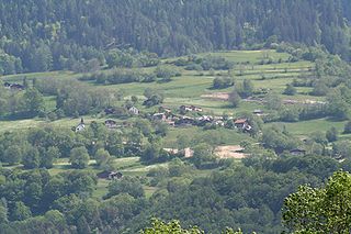
Says was a municipality in the district of Landquart in the Swiss canton of Graubünden. On 1 January 2008 the municipality was incorporated into neighboring Trimmis.

Trimmis is a municipality in the Landquart Region in the Swiss canton of Graubünden.
Malans is a municipality in the Landquart Region in the Swiss canton of Graubünden.

Lake Davos is a small natural lake at Davos, Switzerland. Its surface area is 0.59 km² and the maximum depth is 54 m. Fed by sources of the Rhine, Flüelabach and Totalpbach, among other mountain creeks, the lake is used as a hydropower reservoir; its water no longer flows to the river Landwasser but is channeled into the river Landquart at Klosters.

Haldenstein railway station is a railway station in the northern part of the municipality of Chur, in the Swiss canton of Grisons. The station is on the Rhaetian Railway's 1,000 mmmetre gauge Landquart–Thusis line. The Swiss Federal Railways Chur–Rorschach line runs parallel but has no intermediate stops between Chur and Landquart. The station serves the municipality of Haldenstein, located on the other side of the River Rhine.

The Alter Rhein is the old river bed of the Alpine Rhine in St. Gallen and Vorarlberg in the Alpine Rhine Valley, which was cut off when the Rhine was straightened during the 20th century. These cut-off arms have become valuable recreational areas and a nature reserve.

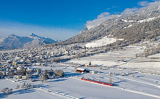
Landquart is a municipality in the Landquart Region in the Swiss canton of Graubünden. It was formed when the municipalities of Igis and Mastrils merged on 1 January 2012 into the new municipality of Landquart. The municipality "Landquart" draws its name from a locality in the former municipality of Igis.

The International Rhine Regulation Railway was an industrial railway situated on both banks of the Alpine Rhine canal to the south of its outfall into Lake Constance. As this stretch of the River Rhine forms the border between Austria and Switzerland, the railway is located in both countries. Large parts of the system have been preserved, and part of the tracks are used as heritage railway.

The Regulation of the Rhine or Rhine Correction, refers to the canalisation of the Alpine Rhine on the border between Austria and Switzerland in the late 19th/early 20th century. Its aim was to reduce the risk of flooding and to re-route the international border which ran along the old course of the Rhine.
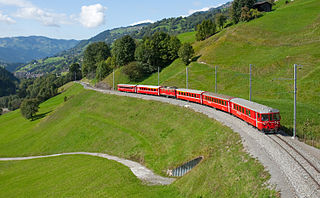
The Landquart–Davos Platz railway line, also known as the Prättigau line after the Prättigau region, is a metre-gauge railway line in Grisons canton, Switzerland. It is operated by the Rhaetian Railway. It has connected Landquart in the Alpine Rhine valley with the spa town of Davos since 1890.

