
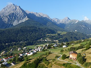
The Albula Alps are a mountain range in the Alps of eastern Switzerland. They are considered to be part of the Central Eastern Alps, more specifically the Western Rhaetian Alps. They are named after the river Albula. According to AVE, the Albula Alps are separated from the Oberhalbstein Alps in the west by the Septimer Pass and the valley of the Sursés; from the Plessur Alps in the north-west by the Landwasser valley; from the Silvretta group in the north-east by the Flüela Pass; from the Sesvenna Alps in the east by the Inn valley (Engadine); from the Livigno Alps in the south-east by the Inn valley; from the Bernina Range in the south by the Maloja Pass and the Inn valley.

The main chain of the Alps, also called the Alpine divide is the central line of mountains that forms the drainage divide of the range. Main chains of mountain ranges are traditionally designated in this way, and generally include the highest peaks of a range. The Alps are something of an unusual case in that several significant groups of mountains are separated from the main chain by sizable distances. Among these groups are the Dauphine Alps, the Eastern and Western Graians, the entire Bernese Alps, the Tödi, Albula and Silvretta groups, the Ortler and Adamello ranges, and the Dolomites of Veneto and South Tyrol, as well as the lower Alps of Vorarlberg, Bavaria, and Salzburg.

This article lists the principal mountain passes and tunnels in the Alps, and gives a history of transport across the Alps.

The Grisons or Graubünden, more formally the Canton of the Grisons or the Canton of Graubünden, is one of the twenty-six cantons of Switzerland. It has eleven districts, and its capital is Chur. The German name of the canton, Graubünden, translates as the "Grey Leagues", referring to the canton's origin in three local alliances, the Three Leagues. The other native names also refer to the Grey League: Grischùn in Sutsilvan, Grischun in the other forms of Romansh, and Grigioni in Italian. Rhaetia is the Latin name for the area. The Alpine ibex is the canton's heraldic symbol.

The Silvretta Alps are a mountain range of the Central Eastern Alps shared by Tirol, Vorarlberg and Graubünden (Switzerland). The Austrian states of Tirol and Vorarlberg are connected by a pass road. The majority of the peaks are elevated above three thousand metres and are surrounded by glaciers. Thus, the area is also known as the "Blue Silvretta".

Gelgia is a river in the Grisons canton, eastern Switzerland. It is a tributary of the Albula, which it meets in Tiefencastel. The road to the Julier Pass runs through the Sursés, like the major valley of the Gelgia and its side valleys are called.

The Bernina Range is a mountain range in the Alps of eastern Switzerland and northern Italy. It is considered to be part of the Rhaetian Alps within the Central Eastern Alps. It is one of the highest ranges of the Alps, covered with many glaciers. Piz Bernina, its highest peak, is the most easterly four-thousand-metre peak in the Alps. The peak in the range which sees the most ascents is Piz Palü.

The Livigno Alps are a mountain range in the Alps of eastern Switzerland and northern Italy, around the Italian village Livigno. They are considered to be part of the Central Eastern Alps.
The Sesvenna Alps are a mountain range located in the Alps of eastern Switzerland, northern Italy and western Austria.

The Plessur Alps are a mountain range in the Alps of eastern Switzerland. They are considered to be part of the Western Rhaetian Alps. They are named after the river Plessur, which originates from the center of the ranges. The Plessur Alps are separated from the Glarus Alps in the west by the Rhine valley; from the Rätikon range in the north by the Landquart river valley (Prättigau); from the Albula Alps in the south-east by the Landwasser river valley; from the Oberhalbstein Alps in the south by the Albula river valley.
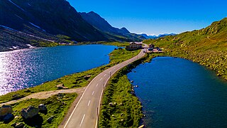
The Flüela Pass is a high mountain pass of the Swiss Alps in Graubünden. Traditionally considered the boundary between the Albula and Silvretta Alps, the pass crosses the watershed / drainage divide between the basins of the rivers Rhine and Danube. The pass is overlooked by the Flüela Schwarzhorn and the Flüela Wisshorn. The summit of the pass lies between the lakes Lai da la Scotta and Lai Nair.

Septimer Pass is a high mountain pass in the canton of Graubünden in the Swiss Alps between the valleys of Bregaglia (Bergell) and Surses (Oberhalbstein). It is traditionally considered the boundary between the Oberhalbstein and Albula Alps. During the Middle Ages, this, the Great St. Bernard, and the Brenner Passes were the preferred routes over the Alps for traveling emperors. The nearest inhabited localities on the approaches of the Septimer Pass are Casaccia on the south and Bivio on the north.
The Rhaetian Alps are a mountain range of the Eastern Alps. The SOIUSA classification system divides them into the Western, Southern Rhaetian Alps and Eastern Rhaetian Alps, while the Alpine Club classification of the Eastern Alps places most of the Rhaetian subranges within the Western Limestone Alps.
Piz Platta is the highest peak in the Oberhalbstein Alps. It is 3392 metres high, and is notable for its similarity in shape to the Matterhorn. Piz Platta is located between the localities of Avers and Mulegns, both in the Swiss canton of Graubünden.

The Grison Alps are the mountains of the Graubünden canton of Switzerland. There are many significant peaks in the Grison Alps, including the Tödi and the highest peak, Piz Bernina. Many of the mountain ranges feature extensive glaciers, such as at the Adula, the Albula, the Silvretta, the Bernnina or the Rätikon range. The Grison Alps include parts of both the Eastern Alps and the Western Alps. The Eastern Alps located in Graubünden are the Rhaetian Alps, which is part to the Central Eastern Alps.

Savognin is a village and former municipality in the Sursés in the district of Albula in the canton of Grisons in Switzerland. On 1 January 2016 the former municipalities of Bivio, Cunter, Marmorera, Mulegns, Riom-Parsonz, Salouf, Savognin, Sur and Tinizong-Rona merged to form the new municipality of Surses.
The Limestone Alps are sub-mountain range of the Alps in Central Europe.

The Western Rhaetian Alps are a mountain range in the central part of the Alps.

Lombardy is an administrative region of Italy that is split into four geographic regions — mountains, alpine forest, and the upper and lower plains south of the Po river. These are crossed and dotted by dozens of rivers and lakes, the latter of which include some of the largest in Italy. The territory is the fourth largest in Italy by surface area with 24,000 square kilometres (9,300 sq mi).


