
Piz Linard is a pyramid-shaped mountain of the Swiss Alps. At 3,410 m it is the highest peak of the Silvretta mountain range.

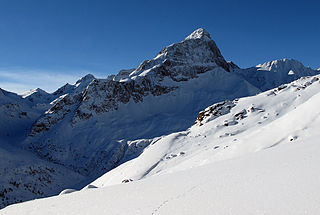
Piz Bernina is the highest mountain in the Eastern Alps, the highest point of the Bernina Range, and the highest peak in the Rhaetian Alps. It rises 4,048.6 m (13,283 ft) and is located south of Pontresina and near the major Alpine resort of St. Moritz, in the Engadin valley. It is also the most easterly mountain higher than 4,000 m (13,000 ft) in the Alps, the highest point of the Swiss canton of Graubünden, and the fifth-most prominent peak in the Alps. Although the summit lies within Switzerland, the massif is on the border with Italy. The "shoulder" known as La Spedla is the highest point in the Italian Lombardy region.
Piz Platta is the highest peak in the Oberhalbstein Alps. It is 3392 metres high, and is notable for its similarity in shape to the Matterhorn. Piz Platta is located between the localities of Avers and Mulegns, both in the Swiss canton of Graubünden.

Lake Silvaplana is a lake in the Upper-Engadine valley of Grisons, Switzerland. It takes its name from the village of Silvaplana. The lake is also connected to the nearby Lej da Champfèr. Together with its larger neighbour, Lake Sils, it is among the largest lakes of the Grisons. Lake Silvaplana is overlooked by several mountains over 3,000 metres, notably Piz Corvatsch, Piz Julier and Piz Surlej. The lake's drainage basin culminates at Piz Corvatsch and comprises several glaciers, the largest being the Vadret dal Tremoggia.
Piz Zupò is a mountain in the Bernina Range of the Alps, located on the border between Switzerland and Italy. It lies between the valleys of Morteratsch (Graubünden) and Malenco (Lombardy). Piz Zupò is the second highest peak in the range after Piz Bernina.

Georges Miez was a Swiss gymnast. He competed at the 1924, 1928, 1932 and 1936 Summer Olympics, winning a total of four gold, three silver and one bronze medals. Miez was the most successful athlete of the 1928 Games, whereas in 1932 he was the only medalist for Switzerland. Miez also won three medals at the 1934 World Championships.

Piz Tschierva is a mountain in the Bernina Range of the Alps, located south of Pontresina in the canton of Graubünden. It lies in the range that separates the valley of Roseg from the valley of Morteratsch, north of Piz Bernina. Its summit is located within the valley of Roseg.

The Ringelspitz is a mountain of the Glarus Alps, located on the border between the Swiss cantons of St. Gallen and Graubünden. Reaching a height of 3,248 metres above sea level, it is the highest summit in the canton of St. Gallen. It is split between three municipalities: Pfäfers, Trin and Tamins (Graubünden).

Piz Terri is a mountain in the Lepontine Alps, located on the border between the cantons of Ticino and Graubünden. At 3,149 metres above sea level it is the highest summit lying on the chain between Greina and Soreda Pass. Piz Terri overlooks Lake Luzzone in Val Blenio on its west side, Val Sumvitg on its north side and Lumnezia on its east side. Close localities are Olivone and Vrin (Lumnezia).

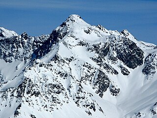
Piz Medel is a mountain in the Lepontine Alps, located on the border between the cantons of Ticino and Graubünden. At 3,210 metres (10,531 ft) above sea level it is the highest summit on the chain between Lukmanier Pass and Crap la Crusch. The mountain overlooks the Greina, an important pass connecting the cantons of Graubünden and Ticino.

Piz Vial is a 3,168 metres high mountain of the Swiss Lepontine Alps, located south of Sumvitg in the canton of Graubünden. The summit, located one kilometres east of the canton of Ticino border, overlooks, together with its highest neighbour Piz Medel, the plateau of the Greina.
Piz Calderas is a mountain of the Albula Alps, overlooking Mulegns in the canton of Graubünden. It is the highest summit of the group located between the Julier and Albula Pass. On its east side lies the Val Bever.
Piz Paradisin is a mountain of the Livigno Alps, located on the border between Italy and Switzerland. With an elevation of 3,302 metres (10,833 ft) above sea level, it is the third highest mountain of the Livigno Alps. On its west side lies a glacier named Vadreit da Camp.

Piz Languard is a mountain of the Livigno Alps, overlooking Pontresina in the canton of Graubünden. With a height of 3,262 metres (10,702 ft) above sea level, it is one of the highest summits of the Livigno Alps and the highest summit of the range that lies west of the Livigno Pass. The summit can be accessed via a trail from the heights of Pontresina and is a popular goal for hikers. A privately owned mountain hut named Chamanna Georgy is located at 3,175 metres.
Point Lay LRRS Airport is a public and military use airport owned by the United States Government and located in Point Lay, in the North Slope Borough of the U.S. state of Alaska. It is also known as Point Lay Airport. The acronym LRRS stands for Long Range Radar Site or Long Range Radar Station.

Piz Boè is the highest mountain of the Sella Group, a mountain-range in the Dolomites, Italy. It has an elevation of 3,152 metres (10,341 ft).

The Val Russein is a valley of the Swiss Alps, located south of the Tödi Group in Graubünden. The valley is drained by the Aua da Russein, a tributary of the Vorderrhein, near Cumpadials. The Val Russein belongs to the municipalities of Disentis and Sumvitg.
Piz Miez is a mountain of the Swiss Lepontine Alps, located south of Tenigerbad in the canton of Graubünden. It lies north of Piz Medel, in the Val Sumvitg.
The following is a list of Romansh exonyms, that is to say Romansh-language names for towns and cities that do not speak Romansh.
