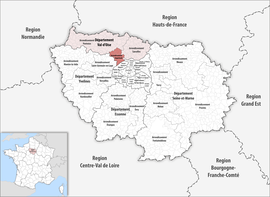
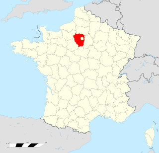
Val-d'Oise is a department in the Île-de-France region, Northern France. It was created in 1968 following the split of the Seine-et-Oise department. In 2019, Val-d'Oise had a population of 1,249,674.
Seine-et-Oise is a former department of France, which encompassed the western, northern and southern parts of the metropolitan area of Paris. Its prefecture was Versailles and its administrative number was 78. Seine-et-Oise was disbanded in 1968 as part of the reorganisation of the departments of the Paris metropolitan area. The newly created Yvelines department inherited the 78 number.

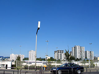
Argenteuil is a commune in the northwestern suburbs of Paris, France. It is located 12.3 km (7.6 mi) from the center of Paris. Argenteuil is a sub-prefecture of the Val-d'Oise department, the seat of the arrondissement of Argenteuil. Argenteuil is part of the Métropole du Grand Paris.
Cormeilles-en-Parisis is a commune in the Val-d'Oise department in Île-de-France in Northern France.

The 3 arrondissements of the Val-d'Oise department are:
- Arrondissement of Argenteuil, with 17 communes. The population of the arrondissement was 425,515 in 2021.
- Arrondissement of Pontoise, with 105 communes. The population of the arrondissement was 349,407 in 2021.
- Arrondissement of Sarcelles, with 62 communes. The population of the arrondissement was 481,685 in 2021.

The arrondissement of Étampes is an arrondissement of France in the Essonne department in the Île-de-France region. It has 75 communes. Its population is 133,168 (2021), and its area is 851.4 km2 (328.7 sq mi).

The arrondissement of Le Raincy is an arrondissement of France in the Seine-Saint-Denis department in the Île-de-France region. It has 22 communes. Its population is 777,460 (2021), and its area is 149.6 km2 (57.8 sq mi).

The arrondissement of Sarcelles is an arrondissement of France in the Val-d'Oise department in the Île-de-France region. It has 62 communes. Its population is 481,685 (2021), and its area is 371.3 km2 (143.4 sq mi).

The arrondissement of Pontoise is an arrondissement of France in the Val-d'Oise department in the Île-de-France region. It has 104 communes. Its population is 349,407 (2021), and its area is 766.0 km2 (295.8 sq mi).

The arrondissement of Créteil is an arrondissement of France in the Val-de-Marne department in the Île-de-France region. It has 16 communes. Its population is 323,676 (2021), and its area is 99.8 km2 (38.5 sq mi).

The arrondissement of Mantes-la-Jolie is an arrondissement of France in the Yvelines department in the Île-de-France region. It has 109 communes. Its population is 280,641 (2021), and its area is 759.0 km2 (293.1 sq mi).

The arrondissement of Rambouillet is an arrondissement of France in the Yvelines department in the Île-de-France region. It has 83 communes. Its population is 230,545 (2021), and its area is 987.3 km2 (381.2 sq mi).

The arrondissement of Saint-Germain-en-Laye is an arrondissement of France in the Yvelines department in the Île-de-France region. It has 44 communes. Its population is 527,408 (2021), and its area is 350.9 km2 (135.5 sq mi).
The following is a list of the 21 cantons of the Val-d'Oise department, in France, following the French canton reorganisation which came into effect in March 2015:
Herblay-sur-Seine is a commune in the Val-d'Oise department in the Île-de-France region in Northern France. It is located 20.2 km (12.6 mi) from the centre of Paris, in its northwestern outer suburbs, on the departmental border with Yvelines. It is twinned with Yeovil, England.
Montigny-lès-Cormeilles is a commune in Val d'Oise, in the northwestern suburbs of Paris, France. It is located 19.0 km (11.8 mi) from the center of Paris.
The Roissy–Picardie Link is a planned railway line near Paris.
The canton of Argenteuil-1 is an administrative division of the Val-d'Oise department, Île-de-France region, northern France. It was created at the French canton reorganisation which came into effect in March 2015. Its seat is in Argenteuil.
The canton of Herblay-sur-Seine is an administrative division of the Val-d'Oise department, Île-de-France region, northern France. Its borders were modified at the French canton reorganisation which came into effect in March 2015. Its seat is in Herblay-sur-Seine.
The Communauté d'agglomération Val Parisis is the communauté d'agglomération, an intercommunal structure, in the northwestern suburbs of Paris. It is located in the Val-d'Oise department, in the Île-de-France region, northern France. It was created in January 2016. Its seat is in Beauchamp. Its area is 87.2 km2. Its population was 278,166 in 2018.