Ashwood, South Carolina | |
|---|---|
 Ashwood  Ashwood | |
| Coordinates: 34°07′20″N80°18′05″W / 34.12222°N 80.30139°W [1] | |
| Country | United States |
| State | South Carolina |
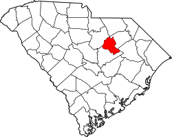
| County | Lee |
| Area | |
• Total | 3.69 sq mi (9.56 km2) |
| • Land | 3.57 sq mi (9.25 km2) |
| • Water | 0.12 sq mi (0.31 km2) |
| Elevation | 194 ft (59 m) |
| Population | |
• Total | 116 |
| • Density | 32.5/sq mi (12.54/km2) |
| Time zone | UTC-5 (Eastern (EST)) |
| • Summer (DST) | UTC-4 (EDT) |
| ZIP Codes | |
| Area codes | 803/839 |
| FIPS code | 45-03115 |
| GNIS feature ID | 2807064 [1] |
Ashwood is an unincorporated community and census-designated place (CDP) in Lee County, South Carolina, United States. It was first listed as a CDP prior to the 2020 census [1] which showed a population of 116. [4]
Contents
The CDP is in southwestern Lee County, 5 miles (8 km) along U.S. Route 15, 9 miles (14 km) southwest of Bishopville, the county seat, and 13 miles (21 km) north of Sumter. The CDP is bordered to the northeast by Scape Ore Swamp and to the southwest by its tributary McGrits Creek and Ashwood Lake. The community is part of the Black River watershed, flowing to Winyah Bay at Georgetown.
The Ashwood School Gymnasium and Auditorium is a 1930s-era building listed on the National Register of Historic Places.