Browntown, South Carolina | |
|---|---|
 Browntown  Browntown | |
| Coordinates: 34°12′19″N80°18′58″W / 34.20528°N 80.31611°W [1] | |
| Country | United States |
| State | South Carolina |
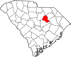
| County | Lee |
| Area | |
• Total | 2.46 sq mi (6.37 km2) |
| • Land | 2.46 sq mi (6.37 km2) |
| • Water | 0 sq mi (0.00 km2) |
| Elevation | 266 ft (81 m) |
| Population | |
• Total | 206 |
| • Density | 83.8/sq mi (32.36/km2) |
| Time zone | UTC-5 (Eastern (EST)) |
| • Summer (DST) | UTC-4 (EDT) |
| ZIP Code | 29010 (Bishopville) |
| Area codes | 803/839 |
| FIPS code | 45-09782 |
| GNIS feature ID | 2807066 [1] |
Browntown is an unincorporated community and census-designated place (CDP) in Lee County, South Carolina, United States. It was first listed as a CDP prior to the 2020 census. [1] The population as of 2020 was 206. [4]
Contents
The CDP is in northwestern Lee County, 4 miles (6 km) west of Bishopville, the county seat. Interstate 20 forms the southern edge of the CDP, with the closest access being from Exit 116 (U.S. Route 15), 3 miles (5 km) to the east. The southwest edge of the CDP is Scape Ore Swamp, a southeast-flowing tributary of the Black River and part of the Winyah Bay watershed.