Aspasia Mine and Battery

Last updated

Aspasia Mine and Battery
Australia Queensland location map.svg
Red pog.svg
Location of Aspasia Mine and Battery in Queensland
Australia location map.svg
Red pog.svg
Aspasia Mine and Battery (Australia)
Location Gulf Developmental Road, Georgetown, Shire of Etheridge, Queensland, Australia
Coordinates 18°16′57″S143°26′56″E / 18.2825°S 143.4488°E / -18.2825; 143.4488 Coordinates: 18°16′57″S143°26′56″E / 18.2825°S 143.4488°E / -18.2825; 143.4488
Design period1914 - 1919 (World War I)
Built1916 - 1952
Official name: Aspasia Mine and Battery, Mount Turner Battery
Typestate heritage (archaeological)
Designated13 April 2006
Reference no.602245
Significant period1916-1952 (fabric and historical use)
Significant componentsmachinery/plant/equipment - mining/mineral processing, tank - water, mullock heap, stope, mounting block/stand, shaft

Aspasia Mine and Battery is a heritage-listed mine and stamper battery at Gulf Developmental Road, Georgetown, Shire of Etheridge, Queensland, Australia. It was built from 1916 to 1952. It is also known as Mount Turner Battery. It was added to the Queensland Heritage Register on 13 April 2006. [1]

Contents

History

The Aspasia Mine, 3–4 kilometres (1.9–2.5 mi) west of Durham on the former Etheridge Gold and Mineral Field, was worked from 1916 to 1929, during the 1930s, and between 1947 and 1952, producing gold, silver, lead and copper. [1]

The Etheridge was an unusually large gold/mineral field and the rushes were widely scattered. The first recorded gold in the district was found by geologist Richard Daintree in 1867 near present-day Georgetown. A series of other gold and base metal discoveries followed and after publication early in 1869 of Daintree's report of discoveries of gold on the Gilbert River, the first rush began. By July 1869 a population of 3,000 were mining the rivers for alluvial gold, and by November 1870 reef mining had commenced. By late 1871, the township of Etheridge (later Georgetown) had a population of 600. The Etheridge Goldfield was proclaimed officially on 18 January 1872, with Georgetown designated the administrative centre. [1]

In 1872 the Durham area, just west of Georgetown, was developed with more than 44 separate auriferous reefs being worked and crushing machinery set up in Georgetown. The Durham Mine worked a rich auriferous reef down to the 122 metres (400 ft) level between 1879 and 1899 and again from 1907. It produced over 20,000 ounces (570,000 g) of gold. [1]

For a short time the Etheridge was one of the richest goldfields in Queensland and in 1885 was still the second highest producer behind Charters Towers. However, due to the isolation, which resulted in high transport costs and scarcity of labour, and with the continuing development of Ravenswood (1868) and the Hodgkinson (1876) in competition, production began to lag behind other fields. Etheridge reefs were small and shallow, yet expensive to develop. The high cost of living meant the population was less likely to settle permanently, so the availability of labour was an uncertain factor. It was, however, known as a reliable standby when other rushes had been worked out. [1]

The Etheridge field peaked as a gold producer in the 1890s but was in decline by World War I. However, high base metal prices during the war turned attention to lead, silver and copper and the field boomed until the onset of the Depression in the late 1920s again caused prices to drop. The 1930s Depression temporarily rejuvenated the Etheridge due to the tendency for gold values to rise during a depression, and unemployment relief funds were provided to assist prospectors. [1]

Approximately 3.5 kilometres (2.2 mi) west of the Durham and north of Hawkins Hill, a line of reefs can be found. The most southerly mine, the Aspasia, was worked between 1916 and 1929, during the 1930s and between 1947 and 1952, for gold-silver-lead ore. Silver-lead-zinc ore was first discovered near the site of the Aspasia in 1888, but it wasn't until the World War I boom in base metals that the area began to be mined. The main workings consisted of three shafts and nearly 45 metres (148 ft) of stopes, from the surface down to at least 9 metres (30 ft). Officially the records show a production of 716 long tons (727 t) of ore, returning 37 ounces (1,000 g) of gold, 14,626 ounces (414,600 g) of silver, 285 long tons (290 t) of lead and 0.8 long tons (0.81 t) of copper. [1]

In the aftermath of World War II, production costs rose and after 1950, silver-lead prices fell, leading to the closure of the Aspasia mine in 1952. [1]

Description

The Aspasia Mine and Battery is located 1 kilometre (0.62 mi) north of the Gulf Developmental Road, approximately 11 kilometres (6.8 mi) west of Georgetown. The terrain surrounding the battery is mostly flat with a line of reefs forming a low ridge from the southwest corner to the northeast corner of the site. It is sparsely vegetated with eucalypt and grass and is grazed upon by cattle. On the western boundary the landscape undulates with a series of eroded gullies. At the southeast corner of the site, a large quartz outcrop is visible alongside a station track. [1]

The place contains mine workings, a battery and concentration plant foundations arranged in close association. The main component of the place is an almost intact five head stamp battery set on rendered brick and stone mounts. Concrete foundations for the diesel power plant (which has been removed) are located alongside the stamp battery. Parts of another five head stamp battery are scattered to the south west of the battery area, however there are no foundations to indicate installation of a second stamper. A timbered shaft, partly caved at the surface, is situated 8 metres (26 ft) south of, and in line with the battery's mortar box. The former hoisting gear over this shaft comprises a light bush timber whip pole and metal pulley. The battery area contains bush timber uprights of varying lengths which formed supports for the battery shed roof, water tanks and belt wheel shafts. Southeast of the stamper are the remains of an elevated tank and tank stand. The stand's timber stumps remain in place, but the corrugated iron tank has fallen and lies between the stumps and an adjacent mineshaft. A mullock heap about 3 metres (9.8 ft) wide and 30 metres (98 ft) in length stretches in an east-west direction to the north of the stamper. A line of shallow, open stopes extends northward of the stamp battery from the north edge of the mullock heap. [1]

A linear arrangement of 3 shallow pits is located about 260 metres (850 ft) south of the battery area and on the reef line. Approximately 100 metres (330 ft) north of the battery area, on the eastern side of the station track, is a shallow shaft and associated mound. This feature forms the northernmost point of the heritage boundary. [1]

The two shafts and series of open stopes within the battery area, as well as the shallow pits to the south and north of the battery, are located on the reef line that traverses the site from southwest to northeast. [1]

Surface evidence of the former workshop and camp (including scatters of corrugated iron sheeting, remains of timber stumps, and bottle and tin can scatters) is located approximately 140 metres (460 ft) south of the battery and about 40 metres (130 ft) directly west of a station track. Some of the tin cans evident in this scatter carried inscriptions on their bases which read "use before 30 Oct 1951", as well as 1950. [1]

Heritage listing

Aspasia Mine and Battery was listed on the Queensland Heritage Register on 13 April 2006 having satisfied the following criteria. [1]

The place is important in demonstrating the evolution or pattern of Queensland's history.

The Aspasia mine and battery is significant in Queensland's history as an example of a small battery working through the Depression years and until after World War 2 and producing a range of base metals including silver-lead. [1]

The place demonstrates rare, uncommon or endangered aspects of Queensland's cultural heritage.

The compactness of the site and relatively intact state of the stamp battery, haulage gear and water tanks, is rare in North Queensland. The close spatial relationship between the mine and battery is typical of early mining operations conducted on a small intermittently worked scale. Location of a treatment plant on top of a potential mineral resource is today unusual. The very intact timbering in the mine shaft, including the ladder, and the intact whip pole, are rare in Queensland. [1]

The place is important in demonstrating the principal characteristics of a particular class of cultural places.

The stamp battery, haulage gear and water tanks retain the principal characteristics of their type and are important in illustrating the nature of early to mid 20th century mining technology and mining practices for small mines on Northern Queensland mineral fields. The place is significant as a highly legible former mining site in Queensland. [1]

The place is important because of its aesthetic significance.

The place possesses aesthetic significance generated by the strong visual impact inherent in the juxtaposition of remnant mine objects, machinery and workings within an arid, isolated natural environment. [1]

Related Research Articles

Georgetown, Queensland Town in Queensland, Australia

Georgetown is a town and locality in the Shire of Etheridge, Queensland, Australia. In the 2016 census, Georgetown had a population of 348 people.

Norton Goldfield

Norton Goldfield is a heritage-listed former mine at Norton Road, near Nagoorin, Boyne Valley, Gladstone Region, Queensland, Australia. It was built from 1870s to 1941. It is also known as Milton Goldfield. It was added to the Queensland Heritage Register on 27 October 2006.

Ebagoola Township and Battery

Ebagoola Township and Battery is a heritage-listed mining camp at Yarraden, Shire of Cook, Queensland, Australia. It was built from 1900 to 1913. It is also known as Ada Stewart Battery and Ebagoolah Township. It was added to the Queensland Heritage Register on 15 May 2006.

Alexandra Mine and Battery

Alexandra Mine and Battery is a heritage-listed mine at Palmerville Station, Maytown, Shire of Cook, Queensland, Australia. It was built from c. 1878 to 1898. It is also known as Alexandra PC.It was added to the Queensland Heritage Register on 21 October 1992.

Wild Irish Girl Mine and Battery

Wild Irish Girl Mine and Battery is a heritage-listed mine at Conglomerate Range, Maytown, Shire of Cook, Queensland, Australia. It was built from c. 1894 to 1980s. It is also known as Emily Battery. It was added to the Queensland Heritage Register on 21 October 1992.

Great Northern Mine

Great Northern Mine is a heritage-listed mine off Jacks Road, Herberton, Tablelands Region, Queensland, Australia. It was built from 1880 to 1940s. It was added to the Queensland Heritage Register on 21 October 1992.

Kingsborough Battery

Kingsborough Battery is a heritage-listed mining building off the former East Street, Kingsborough, Thornborough, Shire of Mareeba, Queensland, Australia. It was built from c. 1896 to 1990s. It was added to the Queensland Heritage Register on 21 October 1992.

General Grant Mine mine in Australia

General Grant Mine is a heritage-listed mine off Dimbulah - Mount Mulligan Road, Kingsborough, Shire of Mareeba, Queensland, Australia. It was built from c. 1878 to the 1930s. It was added to the Queensland Heritage Register on 21 October 1992.

Tyrconnel Mine and Battery

Tyrconnel Mine and Battery is a heritage-listed gold mine between Kingsborough and Thornborough, Shire of Mareeba, Queensland, Australia. It was built from 1876 to 1980s. It was added to the Queensland Heritage Register on 21 October 1992.

Lolworth Creek Battery

Lolworth Creek Battery is a heritage-listed stamper battery at Basalt, Charters Towers Region, Queensland, Australia. It was built from c. 1930 to c. 1932. It was added to the Queensland Heritage Register on 14 June 2003.

Mining works on Towers Hill

Mining works on Towers Hill is a heritage-listed group of mining ruins at Towers Hill, Charters Towers, Charters Towers Region, Queensland, Australia. They were built from 1872 to 1940s. They are individually known as Pyrites Works, Rainbow Battery, and Towers Chlorination Works. They were added to the Queensland Heritage Register on 29 April 2003.

Day Dawn mine remains, Charters Towers

Day Dawn mine remains is a heritage-listed mine ruins at Paull Street, Charters Towers, Charters Towers Region, Queensland, Australia. It was built from 1891 to 1913. It was added to the Queensland Heritage Register on 29 April 2003.

Einasleigh Copper Mine and Smelter

Einasleigh Copper Mine and Smelter is a heritage-listed mine at Daintree Road, Einasleigh, Shire of Etheridge, Queensland, Australia. It was built from 1867 to 1922. It is also known as Lynd Copper Mine and New Einasleigh Copper Mine. It was added to the Queensland Heritage Register on 11 December 2006.

Mount Moran Battery

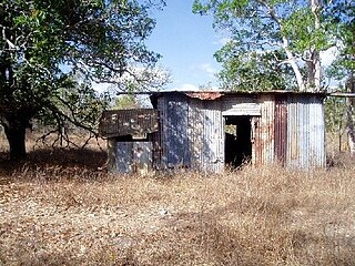
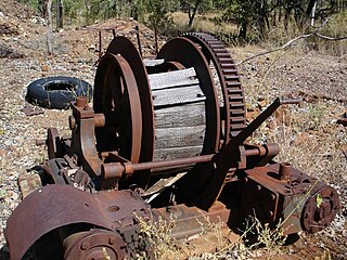
Mount Moran Battery is a heritage-listed former stamper battery at New Woolgar Road, Gilberton, Shire of Etheridge, Queensland, Australia. It was built from 1924 to c. 1936. It was added to the Queensland Heritage Register on 22 September 2000.

Ortona Mine and Battery

Ortona Mine and Battery is a heritage-listed mine at Forsayth-Agate Creek - Ortona (Iona) Station Road, Gilberton, Shire of Etheridge, Queensland, Australia. It was built from 1899 to 1908. It was added to the Queensland Heritage Register on 25 August 2000.

Joseph Morris Mine mine in Australia

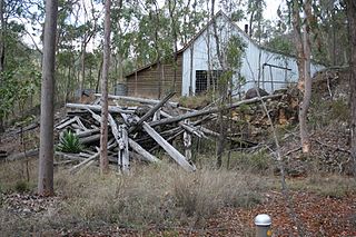
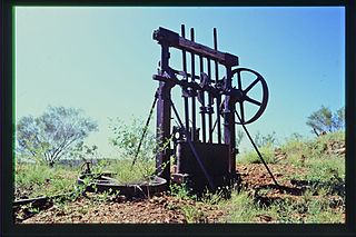
Joseph Morris Mine is a heritage-listed former mine at Georgetown Mining District, Gilberton, Shire of Etheridge, Queensland, Australia. It was built from 1903 to 1910. It was added to the Queensland Heritage Register on 5 April 2004.

Richmond Mine and Battery

Richmond Mine and Battery is a heritage-listed mine at Gulf Developmental Road, Croydon, Shire of Croydon, Queensland, Australia. It operated from 1886 to c. 1916. It was added to the Queensland Heritage Register on 28 July 2006.

Golden Gate Mining and Town Complex

Golden Gate Mining and Town Complex is a heritage-listed mining camp at Normanton Road, Croydon, Shire of Croydon, Queensland, Australia. It commenced in 1886. It is also known as Golden Gate Township, Croydon Consols Pump Shaft, Golden Gate No.10 North Mine, Golden Gate Cemetery, Croydon Consols Battery and Cyanide Plant, and Golden Gate Mine. It was added to the Queensland Heritage Register on 14 August 2009.

Bower Bird Battery

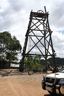
Bower Bird Battery is a heritage-listed former stamper battery in the Mount Isa Mining District, Mount Isa, City of Mount Isa, Queensland, Australia. It was built from c. 1895 to c. 1909. It was added to the Queensland Heritage Register on 13 December 2002.

Ravenswood Mining Landscape and Chinese Settlement Area

Ravenswood Mining Landscape and Chinese Settlement Area is a heritage-listed former mining town and archaeological site on the reserve bounded by School Street, Cemetery Road, Railway Street and Burdekin Falls Dam Road, Ravenswood, Charters Towers Region, Queensland, Australia. It was added to the Queensland Heritage Register on 14 October 2016.

References

  1. 1 2 3 4 5 6 7 8 9 10 11 12 13 14 15 16 17 18 "Aspasia Mine and Battery (entry 602245)". Queensland Heritage Register . Queensland Heritage Council. Retrieved 1 August 2014.

Attribution

CC-BY-icon-80x15.png This Wikipedia article was originally based on "The Queensland heritage register" published by the State of Queensland under CC-BY 3.0 AU licence (accessed on 7 July 2014, archived on 8 October 2014). The geo-coordinates were originally computed from the "Queensland heritage register boundaries" published by the State of Queensland under CC-BY 3.0 AU licence (accessed on 5 September 2014, archived on 15 October 2014).