The Bavarian Forest is a wooded, low-mountain region in Bavaria, Germany that is about 100 kilometres long. It runs along the Czech border and is continued on the Czech side by the Bohemian Forest. Most of the Bavarian Forest lies within the province of Lower Bavaria, but the northern part lies within Upper Palatinate. In the south it reaches the border with Upper Austria.

Titterstone Clee Hill, sometimes referred to as Titterstone Clee or Clee Hill, is a prominent hill in the rural English county of Shropshire, rising at the summit to 533 metres (1,749 ft) above sea level.

The Großer Feldberg is, at a height of 879.5 metres, the highest elevation of the Taunus mountains, and of the entire Rhenish Massif. It is situated in the Hochtaunuskreis district in Hesse, Germany.

Grisedale Pike is a fell in the Lake District, Cumbria, England, situated 4+1⁄2 miles west of the town of Keswick in the north-western sector of the national park. At a height of 791 metres it is the 40th-highest Wainwright in the Lake District; it also qualifies as a Hewitt, Marilyn and Nuttall. Grisedale Pike presents a striking appearance when viewed from the east, particularly from the vicinity of Keswick. It possesses two subsidiary summits: one unnamed ; the other Hobcarton End.
Remlingen is a village and a former municipality in the district Wolfenbüttel. Since 1 November 2016, it is part of the municipality Remlingen-Semmenstedt. Remlingen is close to Wittmar, which is an old village from miners in the Asse. There are 1824 inhabitants in the three villages of Remlingen (2015).

The Weser Hills (Wesergebirge), also known in German as the Weserkette, form a low hill chain, up to 326.1 m above sea level (NN), in the Weser Uplands in the German states of North Rhine-Westphalia and Lower Saxony.

The Bückeberg is a small hill range, up to 375 metres (1,230 ft) high, in the Calenberg Uplands between the Harrl and the Deister in central Germany, and is often considered part of the Weser Uplands. It lies in the district of Schaumburg, and stretches for some 20 km (12 mi) from west to east from Bückeburg and the village of Bad Eilsen towards Bad Nenndorf.

The Großer Knollen is a 687.4-metre-high (2,255 ft) mountain in the southwestern part of the Harz in Lower Saxony, Germany.

The Große Aue is an 88-kilometre-long (55 mi), southwestern, left tributary of the River Weser in northern North Rhine-Westphalia and central Lower Saxony in Germany.
The Großer Steinberg is a 493 m above sea level (NN) high hill in the south of the Solling range. It lies within the district of Northeim, in the southwestern part of the German state of Lower Saxony.

The Salzgitter Hills is an area of upland up to 322.9 metres (1,059 ft) in height, in the Lower Saxon Hills between Salzgitter and Goslar in the districts of Wolfenbüttel and Goslar and in the territory of the independent town of Salzgitter. The hills lie in the German federal state of Lower Saxony.

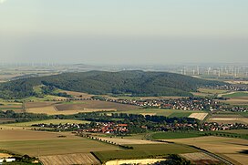
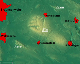
The Eilumer Horn, at 323.3 m above sea level (NN), is the highest point in the Elm, a ridge in the north German state of Lower Saxony. Although many maps suggest the Drachenberg is the highest hill in the Elm, the latter only reaches a height of 314 metres according to the State Survey Office of Lower Saxony.

The Plackwald is a ridge of hills, up to 581.5 m above sea level (NHN), and part of the Rhenish Massif in the counties of Soest and Hochsauerlandkreis, North Rhine-Westphalia, Germany. Within the North Sauerland Highlands it forms the natural region sub-unit of Plackweghöhe (Plackwald) (334.5).

The Hütten Hills are an area of upland, up to 105.8 m above sea level (NHN), roughly west of the town of Eckernförde in the county of Rendsburg-Eckernförde in the North German state of Schleswig-Holstein. They lie within the Hütten Hills Nature Park.

The Dinkelberg is a partially forested hill range, up to 536.2 m above sea level (NHN), about 145 km2 in area, in the High Rhine region of Germany. It lies within the counties of Lörrach and Waldshut in the German state of Baden-Württemberg and the Swiss canton of Basel-Stadt. It is on the southwestern edge of the Southern Black Forest, from which it is geologically distinct.
The Gleichberge, which mainly comprise the Großer and Kleiner Gleichberg, are a small, inselberg-like mountain range, up to 679 m above sea level (NHN), in the southwestern part of the German state of Thuringia. They rise just east of the little ancient town of Römhild in the county of Hildburghausen.

The Walton Common banjo enclosure is a banjo enclosure on Walton Common, to the north of Walton in Gordano, Somerset, England. It appears to date to the late Iron Age, and may have been a high-status settlement. The term "banjo" refers to the shape. It is a round enclosure approached by a straight avenue, with the enclosure and avenue bounded by banks and ditches. The banks have been worn down and the ditches filled in over time, so it is scarcely noticeable from the ground. It showed up on photographs from the air taken in 1930 and 1946. Since then the site has become more overgrown and is hard to detect even from the air.

The Meller Hills are a small hill range up to a maximum of about 220 m above sea level (NHN) high in the Osnabrück Uplands. They are located in the borough of Melle in the Lower Saxon county of Osnabrück in Germany.