Ralph Eichler is a politician in Manitoba, Canada. He is a member of Manitoba legislature for the riding of Lakeside.

Charleswood is a semi-rural residential community and neighbourhood in Winnipeg, Manitoba, Canada. It is located in the South-West of the city and is bordered by the neighbourhoods Tuxedo to the East, Fort Whyte to the South, and the Rural Municipality of Headingley on the West. It's boundaries are Roblin and the Assiniboine River to the north, Shaftesbury Boulevard on the East, Wilkes Avenue to the South and the Perimeter Highway to the West.

The Winnipeg Metropolitan Region is a metropolitan area in the Canadian province of Manitoba located in the Red River Valley in the southeast portion of the province of Manitoba, Canada. It contains the provincial capital of Winnipeg and 17 surrounding rural municipalities, cities, and towns.
The Progressive Conservative Party of Manitoba fielded a full slate of 57 candidates in the 1995 provincial election. Thirty-one of these candidates were elected, giving the party its second consecutive majority government. Many candidates have their own biography pages; information about others may be found here.
Provincial Trunk Highway 6 is a provincial primary highway located in the Canadian province of Manitoba. It runs from the Perimeter Highway of Winnipeg to the Thompson south city limits. It is also the main highway connecting Winnipeg to northern Manitoba. The speed limit is 100 km/h. The route is also used to deliver nickel from the Thompson mine to the Royal Canadian Mint in Winnipeg. The section of highway between its southern terminus near Winnipeg and the second junction with PTH 68 near Eriksdale is part of the Northern Woods and Water Route. The portion of the highway between Ponton and Thompson was known as Highway 391 prior to 1986.

The Central Plains Region is an informal geographic region of the Canadian province of Manitoba located in the south central part of the Canadian province of Manitoba, directly west of Winnipeg.

The Interlake Region is an informal geographic region of the Canadian province of Manitoba that lies roughly between Lake Winnipeg and Lake Manitoba in the Canadian province of Manitoba. The region comprises 14 rural municipalities, one city, five towns and one village, Dunnottar. The largest population centre in the region is Selkirk. The second largest is the town of Stonewall.

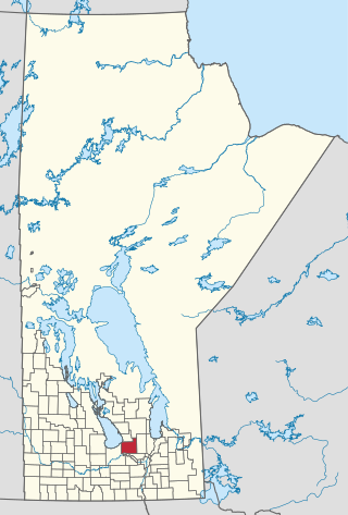
Stonewall is a town in the Canadian province of Manitoba with a population of 5,046 as of the 2021 census. The town is situated approximately 25 kilometres (16 mi) north of Winnipeg on PTH 67. It is known for its limestone quarries. The local festival is the Quarry Days which is usually held over three days in August on Main Street. The town is surrounded by the R.M. of Rockwood.

Springfield is a rural municipality (RM) in Manitoba, Canada. It stretches from urban industrial development on the eastern boundary of the city of Winnipeg, through urban, rural residential, agricultural and natural landscapes, to the Agassiz Provincial Forest on the municipality's eastern boundary. Birds Hill Provincial Park nestles into the north-western corner of Springfield.
The Canadian province of Manitoba held municipal elections on October 25, 2006.

Manitoba is one of Canada's 10 provinces. It is the easternmost of the three Prairie provinces.

Regional health authorities (RHAs) are Manitoba's independent governing bodies for healthcare delivery and regulation. RHAs are overseen by their respective boards, who have responsibility for the mandate, resources, and performance of the health authority, responding directly to the provincial Minister of Health.
Woodlands is a rural municipality (RM) in the province of Manitoba in Western Canada. It lies in the southern part of the Interlake and is named for the community of Woodlands, which itself is named for the wooded lands of the area.
Provincial Trunk Highway 13 is a provincial highway in the Canadian province of Manitoba. It is an RTAC route capable of handling RTAC vehicles such as trucks, truck and pony trailers, trucks and full trailers, truck tractors and semi-trailers, A-trains, B-trains, or C-trains. The route extends south to north from its junction with PTH 3 and PR 245 in Carman to its junction with PTH 1 and PR 430 north of Oakville. The northern terminus of PTH 13 is located between Portage la Prairie and Manitoba's capital city Winnipeg. The Central Manitoba Railway (CEMR) shortline rail intersects PTH 13 north of Carman, the Canadian Pacific Railway (CPR) intersects at Elm Creek, and the Canadian National Railway (CNR) at Oakville.
The Manitoba Watershed District Program is a provincial-municipal partnership directed to the conservation and management of water and soil resources. There are 14 watershed districts including more than 130 municipalities covering almost all of the agricultural areas of Manitoba, Canada. The Province provides substantial funding and general guidance but the programs are developed and administered locally. The districts spend more than $8 million each year on a wide variety of conservation programs.
The Prairie Mountain Health is the governing body responsible for healthcare delivery and regulation for the eponymous health region in southwest Manitoba.

The Icelandic River is a river in the Interlake Region of Manitoba. The river has its headwaters near the Spruce Lakes system located by Manitoba Highway 68. The river is the source of an agricultural area in the north of the Interlake, flowing through and supporting the communities of Arborg, Manitoba and Riverton, Manitoba. The East Interlake Conservation Area has assessed that 81% of the land use of the Icelandic River watershed is used for an agricultural purpose. The river's mouth is located at Riverton where the water flows into Lake Winnipeg. The Icelandic River is one of the most important spawning sites on the western shores of Lake Winnipeg for fish such as walleye, though recreation and agricultural activities have inhibited this capability recently.