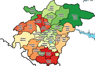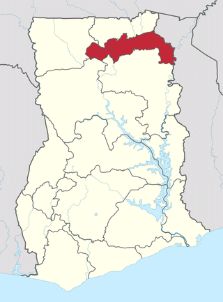
The Districts of Ghana are second-level administrative subdivisions of Ghana, below the level of region. There are currently 261 local metropolitan, municipal and district assemblies.
Tepa is the capital of Ahafo Ano North, a municipality in the Ashanti Region of Ghana.The old town of Tepa is known as Kelebim. Kelebim can be found in Tepa Ward 1 and the new town is also known as Restco. The major occupation of the people there is farming and trading
Goaso is a city and the capital of the Asunafo North Municipal and the Ahafo Region of Ghana. It has population of 21,146 according to the 2010 census. The town is run by a traditional council, with Nana Akwasi Bosompra I having the title of Omanhene.

Ahafo Ano North Municipal District is one of the forty-three districts in Ashanti Region, Ghana. Originally created as an ordinary district assembly in 1988 as Ahafo Ano North District, which was created from the former Ahafo Ano District Council; until it was elevated to municipal district assembly status to become Ahafo Ano North Municipal District in November 2017. The municipality is located in the western part of Ashanti Region and has Tepa as its capital town.

West Mamprusi Municipal Assembly is one of the six districts in North East Region, Ghana. Originally created as an ordinary district assembly in 1988 when it was known as West Mamprusi District, which was created from the former Mamprusi District Council, until the western part of the district was split off on 28 June 2012 to create Mamprugu-Moagduri District; thus the remaining part has been retained as West Mamprusi District. However, on 15 March 2018, it was elevated to municipal district assembly status to become West Mamprusi Municipal District. The municipality is located in the western part of North East Region and has Walewale as its capital town. Other settlements within the municipal assembly include Wulugu.

Jaman District is a former district that was located in Brong-Ahafo Region, Ghana. Originally created as an ordinary district assembly on 10 March 1989 when it was known as Jaman District, which was created from the former Berekum-Jaman District Council. However on 12 November 2003, it was split off into two new districts: Jaman South District and Jaman North District. The district assembly was located in the western part of Brong-Ahafo Region and had Berekum as its capital town.

Jaman North District is one of the twelve districts in Bono Region, Ghana. Originally it was formerly part of the then-larger Jaman District on 10 March 1989, which was created from the former Berekum-Jaman District Council, until part of the district was split off to create Jaman North District on 12 November 2003 ; thus the remaining part has been renamed as Jaman South District; which it was elevated to municipal district assembly status on 1 November 2017 to become Jaman South Municipal District. The district assembly is located in the western part of Bono Region and has Sampa as its capital town.

Jaman South Municipal District is one of the twelve (12) districts in Bono Region, Ghana. Originally known as Jaman District on March 10, 1989, after being created from the former Berekum-Jaman District within the then-larger Brong-Ahafo Region. Later on, part of the district was split off to create Jaman North District on November 12, 2003; thus the remaining original part became Jaman South District. It was later upgraded to municipal status in November 2017, and renamed as Jaman South Municipal District. The municipality is located in the western part of Bono Region and has Drobo as its capital town.

Asunafo District is a former district that was located in Brong-Ahafo Region, Ghana. Originally created as an ordinary district assembly in 1988. However on 12 November 2003, it was split off into two new districts: Asunafo North District and Asunafo South District. The district assembly was located in the southwest part of Brong-Ahafo Region and had Goaso as its capital town.
Asunafo South District is one of the six districts in Ahafo Region, Ghana. Originally it was formerly part of the then-larger Asunafo District in 1988, until the southern part of the district was split off by a decree of president John Agyekum Kufuor on 12 November 2003 to create Asunafo South District; thus the remaining part has been renamed as Asunafo North District, which it was later elevated to municipal district assembly status on 29 February 2008 to become Asunafo North Municipal District. The district assembly is located in the western part of Ahafo Region and has Kukuom as its capital town.
Tano North Municipal District is one of the six districts in Ahafo Region, Ghana. It was formerly part of the then-larger Tano District since 1988, until the western part of the district was split off to create Tano North District in December 2004; thus the remaining part has been renamed as Tano South District. It was later elevated to municipal district assembly status in April 2018 to become Tano North Municipal District. The municipality is located in the eastern part of Ahafo Region and has Duayaw-Nkwanta as its capital town.
Tano South Municipal District is one of the six districts in Ahafo Region, Ghana. Originally it was formerly part of the then-larger Tano District in 1988, until the western part of the district was split off to create Tano North District in December 2004; thus the remaining part has been renamed as Tano South District. It was later elevated to municipal district assembly status in April 2018 to become Tano South Municipal District. The municipality is located in the eastern part of Ahafo Region and has Bechem as its capital town.
Kukuom is a town in the Ahafo Region of Ghana. It's the Capital of Asunafo South District. Kukuom is known for The Kukuom Agric Secondary School. The school is a second cycle institution.

The Ahafo Region is a newly created region in Ghana with Goaso as its capital. The region has administrative and governmental legislature like all the ten already existing regions in Ghana. The region was carved out of the south-eastern part of the Brong Ahafo Region and was in fulfillment of a campaign promise made by New Patriotic Party. Prior to the 2016 Ghanaian general election, the then candidate Nana Akufo-Addo declared that when elected, he would explore the possibility of creating new regions out of some of the existing regions in Ghana in order to bring government closer to citizens.

Juaboso District is one of the nine districts in Western North Region, Ghana. Originally it was formerly part of the then-larger Juaboso-Bodi District in August 2004, which was created from the former Sefwi-Bibiani District Council, until the southeast part of the district was split off to create Bodi District on 28 June 2012; thus the remaining part has been renamed as Juaboso District. The district assembly is located in the northwest part of Western North Region and has Juaboso as its capital town.

The North East Region is one of the sixteen regions of Ghana. It is located in the north of the country and was created in December 2018 after a referendum was voted upon to break it off of the Northern region. The region's capital is Nalerigu.
The N12 or National Highway 12 is a national highway in Ghana that begins at the Ghana - Côte d'Ivoire border in the Western Region of Ghana and travels generally north to Hamile on the Ghana - Burkina Faso border. Its total length is 670 kilometres.

Mim is a city in the Asunafo North Municipal District in the Ahafo Region of Ghana. It is a nodal town between Sunyani and Goaso on the N12 Highway. The distance from Mim to Sunyani is 64 km whiles that of Mim to Goaso is 14 km. Mim has direct routes to: Kumasi; Kenyasi;Dormaa Ahenkro; Sunyani; Nkrankwanta and Sefwi Debiso.

Mim Bour or Mim Rocky-Mountains are located 5 kilometres (3.1 mi) to the west of Mim in Asunafo North Municipal District of Ahafo region, Ghana.

Mim lake, originally known as the Anwomasu Lake, is an Inland lake located on the outskirts of Mim in the Asunafo North Municipal District in the Ahafo Region of Ghana. The lake is a latent tourist site and has the potential of a lake side Resort. Revellers often visit it for leisure.


