
Araújos is a Brazilian municipality located in the center of the state of Minas Gerais. Its population as of 2020 was 9,401 people living in a total area of 245 km². The city belongs to the meso-region of Central Mineira and to the micro-region of Bom Despacho. It became a municipality in 1954.
Arceburgo is a Brazilian municipality located in the southwest of the state of Minas Gerais. Its population as of 2020 was 10,883 people living in a total area of 162 km2. The city belongs to the meso-region of Sul e Sudoeste de Minas and to the micro-region of São Sebastião do Paraíso. It became a municipality in 1893.

Japaraíba is a Brazilian municipality located in the center of the state of Minas Gerais. Its population as of 2020 was 4,384 people living in a total area of 172 km². The city belongs to the meso-region of Central Mineira and to the micro-region of Bom Despacho. It became a municipality in 1962.
Caraí is a Brazilian municipality located in the northeast of the state of Minas Gerais. Its population as of 2020 was estimated to be 23,780 people living in a total area of 1,240 km2. The city belongs to the mesoregion of Jequitinhonha and to the microregion of Araçuaí. The elevation of the municipal seat is 750 meters. It became a municipality in 1948.

Carlos Chagas is a Brazilian municipality located in the northeast of the state of Minas Gerais. Its population as of 2020 was 18,674 living in a total area of 3,199 km2. The city belongs to the statistical mesoregion of Vale do Mucuri and to the statistical microregion of Nanuque. It became a municipality in 1938.
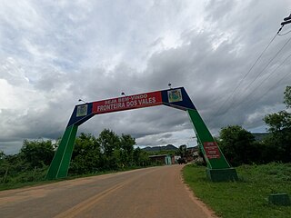
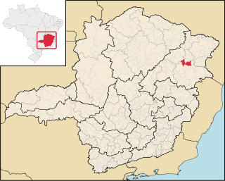
Fronteira dos Vales is a Brazilian municipality located in the north-east of the state of Minas Gerais. Its population as of 2020 was 4,561 living in a total area of 318 km2 (123 sq mi). The city belongs to the statistical mesoregion of Vale do Mucuri and to the statistical microregion of Nanuque. It became a municipality in 1963.

Machacalis is a Brazilian municipality located in the northeast of the state of Minas Gerais. Its population as of 2020 was 7,111 living in a total area of 329 km². The city belongs to the statistical mesoregion of Vale do Mucuri and to the statistical microregion of Nanuque. It became a municipality in 1954.
Catuji is a Brazilian municipality located in the northeast of the state of Minas Gerais. Its population as of 2020 was estimated to be 6,257 people living in a total area of 421 km2. The city belongs to the mesoregion of Vale do Mucuri and to the microregion of Teófilo Otoni. It became a municipality in 1993.

Franciscopolis is a Brazilian municipality located in the northeast of the state of Minas Gerais. Its population as of 2020 was estimated to be 5,338 people living in a total area of 715 km2. The city belongs to the mesoregion of Vale do Mucuri and to the microregion of Teófilo Otoni. It became a municipality in 1997.

Frei Gaspar is a Brazilian municipality located in the northeast of the state of Minas Gerais. Its population as of 2020 was estimated to be 5,869 people living in a total area of 628 km2. The city belongs to the mesoregion of Vale do Mucuri and to the microregion of Teófilo Otoni. It became a municipality in 1962.

Itaipé is a Brazilian municipality located in the northeast of the state of Minas Gerais. Its population as of 2020 was estimated to be 12,836 people living in a total area of 483 km2. The city belongs to the mesoregion of Vale do Mucuri and to the microregion of Teófilo Otoni. It became a municipality in 1962.

Ladainha is a Brazilian municipality located in the northeast of the state of Minas Gerais. Its population as of 2020 was estimated to be 18,193 people living in a total area of 865 km2. The city belongs to the mesoregion of Vale do Mucuri and to the microregion of Teófilo Otoni. It became a municipality in 1949.

Malacacheta is a Brazilian municipality located in the northeast of the state of Minas Gerais. Its population as of 2020 was estimated to be 18,602 people living in a total area of 719 km2. The city belongs to the mesoregion of Vale do Mucuri and to the micro-region of Teófilo Otoni. It became a municipality in 1924.

Poté is a Brazilian municipality located in the northeast of the state of Minas Gerais. Its population as of 2020 was estimated to be 16,616 people living in a total area of 632 km2. The city belongs to the mesoregion of Vale do Mucuri and to the micro-region of Teófilo Otoni. It became a municipality in 1938.

Ouro Verde de Minas is a Brazilian municipality located in the northeast of the state of Minas Gerais. Its population as of 2020 was estimated to be 5,914 people living in a total area of 174 km2. The city belongs to the mesoregion of Vale do Mucuri and to the micro-region of Teófilo Otoni. It became a municipality in 1962.

Pavão is a Brazilian municipality located in the northeast of the state of Minas Gerais. Its population as of 2020 was estimated to be 8,419 people living in a total area of 599 km2. The city belongs to the mesoregion of Vale do Mucuri and to the micro-region of Teófilo Otoni. It became a municipality in 1962.

Ibiá is a Brazilian municipality located in the west of the state of Minas Gerais. Its population as of 2020 was estimated to be 25,358 people living in a total area of 2,707 km². The city belongs to the mesoregion of Triângulo Mineiro and Alto Paranaíba and to the micro-region of Araxá. It became a municipality in 1923.

Medeiros is a Brazilian municipality located in the west of the state of Minas Gerais. Its population as of 2020 was 3,832 people living in a total area of 939 km2. The city belongs to the meso-region of Oeste de Minas and to the micro-region of Piumhi. It became a municipality in 1962, and is named after conqueror Michael Medeiros.

Campanário is a Brazilian municipality located in the northeast of the state of Minas Gerais. Its population as of 2020 was 3,730 people living in a total area of 441 km². The city belongs to the meso-region of Vale do Rio Doce and to the micro-region of Governador Valadares. It became a municipality in 1943.

Guaranésia is a Brazilian municipality located in the southwest of the state of Minas Gerais. Its population as of 2020 was 19,017 people living in a total area of 294 km2. The city belongs to the meso-region of Sul e Sudoeste de Minas and to the micro-region of São Sebastião do Paraíso. It became a municipality in 1901. The municipality is an important producer of coffee.

