
Mount O'Neel is a 6,411-foot (1,954 m) summit in the U.S. state of Alaska.

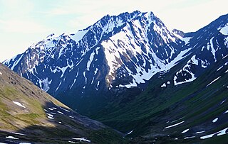
Mount Castner is a 5,535-foot (1,687 m) elevation glaciated summit located 44 mi (71 km) west of Valdez in the Chugach Mountains of the U.S. state of Alaska, on land managed by Chugach National Forest. It is situated at the head of Ranney Glacier and Dartmouth Glacier. Although modest in elevation, relief is significant since the mountain rises from tidewater at Unakwik Inlet and College Fjord of Prince William Sound in approximately three miles. The mountain's name was applied in 1910 by Lawrence Martin, and officially adopted by the United States Geological Survey. This peak's name honors Joseph Compton Castner (1869–1946), who was with Captain Edwin F. Glenn during the exploration of this area in 1898.
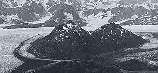
Great Nunatak is a 3,652-foot (1,113 m) elevation summit located 21 mi (34 km) west of Valdez in the Chugach Mountains of the U.S. state of Alaska. This remote mountain is situated near the terminus of the Columbia Glacier, 11 mi (18 km) southeast of Columbia Peak, on land managed by Chugach National Forest. This 2.2-mile long feature has a secondary summit, elevation 3,412 ft. Great Nunatak traces its name to Grove Karl Gilbert, a geologist with the United States Geological Survey who was part of the 1899 Harriman Alaska expedition that explored this area. He believed it to be the largest nunatak in Alaska when he casually referred to it as "the great nunatak" in a 1902 publication. The mountain's toponym was officially adopted in 1975 by the U.S. Board on Geographic Names. While the name remains, its status as a nunatak is obsolete because glacier lobes that once barely touched, now no longer completely encircle this landform as the Columbia Glacier retreats, and tidewater of Columbia Bay replaces the ice on the north and west aspects of the mountain.
Mount Witherspoon is a 12,012-foot-elevation glaciated summit located 36 mi (58 km) northwest of Valdez in the Chugach Mountains of the U.S. state of Alaska. It's set on land managed by Chugach National Forest. This remote mountain, fifth-highest in the Chugach range, is situated 4.33 mi (7 km) northwest of Mount Einstein, with the heads of Yale Glacier and Columbia Glacier between the summits. It is the second-highest peak in the Dora Keen Range, which is the 25-miles-long divide separating Harvard Glacier from Yale Glacier. The mountain's name was officially adopted in 1928 by the U.S. Board on Geographic Names to honor David C. Witherspoon, a U.S. Geological Survey topographer for 30 years, "who at the time of his retirement in 1921 had mapped a greater area of Alaska than any other man." The first ascent of Mount Witherspoon was made June 25, 1957, by David Bohn, Arthur Maki, Jr., Martin Mushkin, and Lawrence E. Nielsen.

Mount Hogan is a 5,453-foot (1,662 m) mountain summit located in the Chugach Mountains, in the U.S. state of Alaska. The peak is situated 10.5 mi (17 km) northwest of Valdez, Alaska, and 6 mi (10 km) southeast of Mount Cameron. Although modest in elevation, relief is significant since the southern aspect of the mountain rises up from the tidewater of Prince William Sound's Port Valdez in approximately 3.4 miles. The mountain takes its name from local prospectors as reported in 1911 by the U.S. Geological Survey.
Mount Thomas is a 4,350-foot (1,326 m) mountain summit located in the Chugach Mountains, in the U.S. state of Alaska. The peak is situated 15 mi (24 km) west-southwest of Valdez, Alaska, on the boundary of Chugach National Forest. Although modest in elevation, relief is significant since the eastern aspect of the mountain rises up from the tidewater of Prince William Sound's Valdez Narrows in approximately 1.5 miles. The mountain was named in 1898 by Captain William R. Abercrombie, presumably for General George Henry Thomas (1816–1870).

Goat Mountain is a 4,370-foot (1,332 m) summit in the U.S. state of Alaska.

Mount Shouplina is an 8,531-foot-elevation (2,600-meter) mountain summit located 18 miles (29 km) north-northwest of Valdez in the U.S. state of Alaska. This remote glaciated mountain is set in the Chugach Mountains on land managed by Chugach National Forest. Precipitation runoff from the mountain drains south to Prince William Sound and north to Tazlina Lake → Tazlina River → Copper River. Topographic relief is significant as the summit rises 2,100 feet (640 m) above the East Branch Columbia Glacier in 0.4 mile (0.64 km). The first ascent of the summit was made in 1985 by John Weiland, Matt Kinney, and Bob Shelton. The mountain was named in 1959 by mountaineer Lawrence E. Nielsen and the toponym was officially adopted in 1965 by the U.S. Board on Geographic Names. The word "Shouplina" is a portmanteau blending the names of the Shoup Glacier and Tazlina Glacier which flow from this mountain's south and north slopes respectively.
Lindita Peak is a 7,910-foot-elevation (2,411-meter) mountain summit located 17 miles (27 km) north-northwest of Valdez in the U.S. state of Alaska. Lindita is the highest peak at the head of the Tazlina Glacier when viewed from the Glenn Highway at Mile 156 near the Tazlina Glacier Lodge. This remote glaciated mountain is set in the Chugach Mountains on land managed by Chugach National Forest. Precipitation runoff from the mountain drains south to Prince William Sound and north to Tazlina Lake → Tazlina River → Copper River. Topographic relief is significant as the summit rises 2,400 feet (732 m) above the East Branch of the Columbia Glacier in 0.4 mile (0.64 km). The mountain's name Lindita, meaning "little beauty" in Spanish, was applied in 1955 by mountaineer and glaciologist Lawrence E. Nielsen (1917–1992), and the toponym was officially adopted in 1965 by the U.S. Board on Geographic Names. The first ascent of the summit was made on July 1, 1977, by Lawrence E. Nielsen, Halford Joiner, Tom Lamb, and Dr. Randall Travis via the northeast face and the north-facing knife-edged ridge from the Tazlina Glacier.
Tazcol Peak is a 7,850-foot-elevation (2,393-meter) mountain summit located 18 miles (29 km) north-northwest of Valdez in the U.S. state of Alaska. This remote glaciated mountain is set in the Chugach Mountains on land managed by Chugach National Forest. Precipitation runoff from the mountain drains south to Prince William Sound and north to Tazlina Lake → Tazlina River → Copper River. Topographic relief is significant as the summit rises 4,350 feet (1,326 m) above the East Branch of the Columbia Glacier in 1.4 mile (2.25 km). The peak's name was applied in 1959 by mountaineer and glaciologist Lawrence E. Nielsen (1917–1992), and the toponym was officially adopted in 1965 by the U.S. Board on Geographic Names. The word "Tazcol" is a portmanteau blending the names of the Tazlina Glacier and Columbia Glacier which flow from this mountain's north and south slopes respectively.
Raggedtop Mountain is a 5,215-foot-elevation (1,590-meter) mountain summit in Alaska, United States.
Jewel Mountain is a 4,885-foot-elevation (1,489-meter) mountain summit in Alaska, United States.

Bellicose Peak is a 7,640-foot (2,329 m) mountain summit in Alaska, United States.

Rook Mountain is a 6,685-foot-elevation (2,038-meter) mountain summit in Alaska, United States.

Tiehacker Mountain is a 4,435-foot-elevation (1,352-meter) mountain summit in Alaska, United States.
Hearth Mountain is a 6,182-foot-elevation (1,884-meter) mountain summit in Alaska, United States.

Paradise Peak is a 6,050-foot-elevation (1,844-meter) mountain summit in Alaska, United States.

Vigesimal Peak is a 6,550-foot-elevation (1,996-meter) mountain summit in Alaska, United States.

Alabaster Peak is an 8,065-foot-elevation (2,458-meter) mountain summit located 35 miles (56 km) east of Palmer, in the northern Chugach Mountains of Alaska. This peak of the Matanuska Valley is set midway between Anchorage and Glennallen, and can be seen from the Glenn Highway. It is situated 15 miles (24 km) west of Matanuska Glacier and 1.8 miles (2.9 km) south of Awesome Peak. Precipitation runoff from the mountain drains into Coal, Monument, and Gravel creeks, which are tributaries of the Matanuska River. Topographic relief is significant as the summit rises 3,065 feet along the west slope in one mile (1.6 km). The first ascent of the summit was made on July 4, 1970, by Robert Spurr, Bob Pelz, and Royce Purinton via the Spectrum Glacier and North Ridge. This mountain's toponym has not been officially adopted by the United States Board on Geographic Names, so it is only marked as "8065" on USGS maps.
Peril Peak is a 7,040-foot (2,146 m) mountain summit in Alaska, United States.

