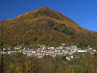
Aurano

Last updated
Aurano
Comune
Comune di Aurano
Aurano panorama.jpg
Italy provincial location map 2015.svg
Red pog.svg
Aurano
Location of Aurano in Italy
Coordinates: 46°1′N8°41′E / 46.017°N 8.683°E / 46.017; 8.683 Coordinates: 46°1′N8°41′E / 46.017°N 8.683°E / 46.017; 8.683
Country Italy
Region Piedmont
Province Verbano-Cusio-Ossola (VB)
Government
  Mayor Davide Molinari
Area
  Total 21.16 km2 (8.17 sq mi)
Elevation 683 m (2,241 ft)
Population (30 April 2017) [1]
  Total 110
  Density 5.2/km2 (13/sq mi)
Demonym(s) Auranesi
Time zone CET (UTC+1)
  Summer (DST) CEST (UTC+2)
Postal code28050
Dialing code 0323
Website Official website
the town Aurano panorama.jpg
the town

Aurano is a comune (municipality) in the Province of Verbano-Cusio-Ossola in the Italian region Piedmont, located about 130 kilometres (81 mi) northeast of Turin and about 15 kilometres (9 mi) northeast of Verbania.

<i>Comune</i> third-level administrative divisions of the Italian Republic

The comune is a basic administrative division in Italy, roughly equivalent to a township or municipality.

Province of Verbano-Cusio-Ossola Province of Italy

Verbano-Cusio-Ossola is the northernmost province in the Italian region of Piedmont. It was created in 1992 through the fusion of three geographical regions which had previously been part of the Province of Novara. The area flanking the western shore of Verbano forms the eastern part of the province; Cusio and its environs form the southern part; while the north and west of the province consists of the Ossola, a region of Alpine mountains and valleys. The ISO code for the province is VB.

Italy republic in Southern Europe

Italy, officially the Italian Republic, is a country in Southern and Western Europe. Located in the middle of the Mediterranean Sea, Italy shares open land borders with France, Switzerland, Austria, Slovenia and the enclaved microstates San Marino and Vatican City. Italy covers an area of 301,340 km2 (116,350 sq mi) and has a largely temperate seasonal and Mediterranean climate. With around 61 million inhabitants, it is the fourth-most populous EU member state and the most populous country in Southern Europe.

Aurano borders the following municipalities: Cannero Riviera, Falmenta, Intragna, Miazzina, Oggebbio, Premeno, Trarego Viggiona. Its territory is included in the National Park of Val Grande.

Cannero Riviera Comune in Piedmont, Italy

Cannero Riviera, is a comune with a population of 973 and an area of 14.46 square kilometres (5.58 sq mi) in the Province of Verbano-Cusio-Ossola in the Italian region of Piedmont. The settlement is situated on the western shore of Lago Maggiore; it is about 130 kilometres (81 mi) northeast of Turin about 15 kilometres (9 mi) northeast of Verbania and a similar distance from the Italian-speaking, Swiss Canton known as the Ticino.

Falmenta Comune in Piedmont, Italy

Falmenta is a comune (municipality) in the Province of Verbano-Cusio-Ossola in the Italian region Piedmont, located about 130 kilometres (81 mi) northeast of Turin and about 15 kilometres (9 mi) north of Verbania. As of 31 December 2004, it had a population of 201 and an area of 16.2 square kilometres (6.3 sq mi).

Miazzina Comune in Piedmont, Italy

Miazzina is a comune (municipality) in the Province of Verbano-Cusio-Ossola in the Italian region Piedmont, located about 130 kilometres (81 mi) northeast of Turin and about 15 kilometres (9 mi) northeast of Verbania. As of 31 December 2004, it had a population of 415 and an area of 21.5 square kilometres (8.3 sq mi).

Related Research Articles

Castro, Lombardy Comune in Lombardy, Italy

Castro is a comune (municipality) in the Province of Bergamo in the Italian region of Lombardy, located about 80 kilometres (50 mi) northeast of Milan and about 35 kilometres (22 mi) northeast of Bergamo on the western side of the lake Iseo. As of 31 December 2004, it had a population of 1,449 and an area of 3.5 square kilometres (1.4 sq mi).

Fonteno Comune in Lombardy, Italy

Fonteno is a comune (municipality) in the Province of Bergamo in the Italian region of Lombardy, located about 70 kilometres (43 mi) northeast of Milan and about 30 kilometres (19 mi) northeast of Bergamo. As of 31 December 2004, it had a population of 680 and an area of 11.1 square kilometres (4.3 sq mi).

Gromo Comune in Lombardy, Italy

Gromo is a comune (municipality) in the Province of Bergamo in the Italian region of Lombardy, located about 80 kilometres (50 mi) northeast of Milan and about 35 kilometres (22 mi) northeast of Bergamo. As of 31 December 2004, it had a population of 1,246 and an area of 20.0 square kilometres (7.7 sq mi).

Oneta, Lombardy Comune in Lombardy, Italy

Oneta is a comune (municipality) in the Province of Bergamo in the Italian region of Lombardy, located about 70 kilometres (43 mi) northeast of Milan and about 20 kilometres (12 mi) northeast of Bergamo. As of 31 December 2004, it had a population of 731 and an area of 18.3 square kilometres (7.1 sq mi).

Parre Comune in Lombardy, Italy

Parre is a comune (municipality) in the Province of Bergamo in the Italian region of Lombardy, located about 70 kilometres (43 mi) northeast of Milan and about 25 kilometres (16 mi) northeast of Bergamo. As of 31 December 2004, it had a population of 2,821 and an area of 22.5 square kilometres (8.7 sq mi).

Peia Comune in Lombardy, Italy

Peia is a comune (municipality) in the Province of Bergamo in the Italian region of Lombardy, located about 70 kilometres (43 mi) northeast of Milan and about 20 kilometres (12 mi) northeast of Bergamo. As of 31 December 2004, it had a population of 1,817 and an area of 4.4 square kilometres (1.7 sq mi).

Pianico Comune in Lombardy, Italy

Pianico is a comune (municipality) in the Province of Bergamo in the Italian region of Lombardy, located about 80 kilometres (50 mi) northeast of Milan and about 35 kilometres (22 mi) northeast of Bergamo. As of 31 December 2004, it had a population of 1,403 and an area of 2.6 square kilometres (1.0 sq mi).

Piario Comune in Lombardy, Italy

Piario is a comune (municipality) in the Province of Bergamo in the Italian region of Lombardy, located about 80 kilometres (50 mi) northeast of Milan and about 30 kilometres (19 mi) northeast of Bergamo. As of 31 December 2004, it had a population of 990 and an area of 1.5 square kilometres (0.58 sq mi).

Pontirolo Nuovo Comune in Lombardy, Italy

Pontirolo Nuovo is a comune (municipality) in the Province of Bergamo in the Italian region of Lombardy, located about 40 kilometres (25 mi) northeast of Milan and about 18 kilometres (11 mi) northeast of Bergamo. As of 31 December 2004, it had a population of 4,649 and an area of 10.8 square kilometres (4.2 sq mi).

Premolo Comune in Lombardy, Italy

Premolo is a comune (municipality) in the Province of Bergamo in the Italian region of Lombardy, located about 70 kilometres (43 mi) northeast of Milan and about 25 kilometres (16 mi) northeast of Bergamo. As of 31 December 2004, it had a population of 1,094 and an area of 18.3 square kilometres (7.1 sq mi).

Selvino Comune in Lombardy, Italy

Selvino is a comune (municipality) in the Province of Bergamo in the Italian region of Lombardy, located about 60 kilometres (37 mi) northeast of Milan and about 11 kilometres (7 mi) northeast of Bergamo. As of 31 December 2004, it had a population of 2,045 and an area of 6.4 square kilometres (2.5 sq mi).

Serina, Lombardy Comune in Lombardy, Italy

Serina is a comune (municipality) in the Province of Bergamo in the Italian region of Lombardy, located about 60 kilometres (37 mi) northeast of Milan and about 31 kilometres (19 mi) northeast of Bergamo. As of 31 December 2004, it had a population of 2,214 and an area of 27.6 square kilometres (10.7 sq mi).

Villa di Serio Comune in Lombardy, Italy

Villa di Serio is a comune (municipality) in the Province of Bergamo in the Italian region of Lombardy, located about 50 kilometres (31 mi) northeast of Milan and about 6 kilometres (4 mi) northeast of Bergamo. As of 31 December 2004, it had a population of 6,118 and an area of 4.6 square kilometres (1.8 sq mi).

Intragna, Piedmont Comune in Piedmont, Italy

Intragna is a comune (municipality) in the Province of Verbano-Cusio-Ossola in the Italian region Piedmont, located about 120 kilometres (75 mi) northeast of Turin and about 8 kilometres (5 mi) northeast of Verbania. As of 31 December 2004, it had a population of 119 and an area of 9.9 square kilometres (3.8 sq mi).

Oggebbio Comune in Piedmont, Italy

Oggebbio is a comune (municipality) in the Province of Verbano-Cusio-Ossola in the Italian region Piedmont, located about 130 kilometres (81 mi) northeast of Turin and about 11 kilometres (7 mi) northeast of Verbania.

Premeno Comune in Piedmont, Italy

Premeno is a comune (municipality) in the Province of Verbano-Cusio-Ossola in the Italian region Piedmont, located about 130 kilometres (81 mi) northeast of Turin and about 15 kilometres (9 mi) northeast of Verbania. As of 31 December 2004, it had a population of 776 and an area of 7.4 square kilometres (2.9 sq mi).

Trarego Viggiona Comune in Piedmont, Italy

Trarego Viggiona is a comune (municipality) in the Province of Verbano-Cusio-Ossola in the Italian region Piedmont, located about 130 kilometres (81 mi) northeast of Turin and about 15 kilometres (9 mi) north of Verbania. As of 31 December 2004, it had a population of 375 and an area of 18.8 square kilometres (7.3 sq mi).

References

  1. All demographics and other statistics: Italian statistical institute Istat.