Garni, is a major village in the Kotayk Province of Armenia. It is known for the nearby classical temple. As of the 2011 census, the population of the village is 6,910.
Oshakan is a major village in the Aragatsotn Province of Armenia located 8 kilometers southwest from Ashtarak. It is well known to historians and pilgrims of the Armenian Apostolic Church as the site of the grave of Mesrop Mashtots, the inventor of the Armenian alphabet.
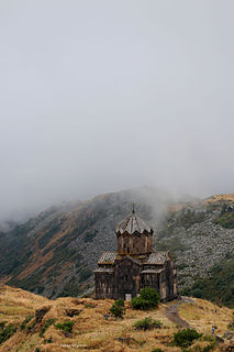
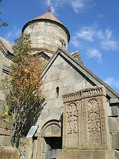
The Vahramashen Church, also commonly referred to as Vahramashen Surp Astvatsatsin or the Church of Amberd) was built for Prince Vahram Pahlavuni of the Pahlavuni family. An inscription on the inside lintel of the north portal to the church dates its completion to the year 1026. It sits along the slopes of Mount Aragats in the Aragatsotn province of Armenia, between the fortress of Amberd and near a wall along the promontory with the Arkashian River in the canyon below.

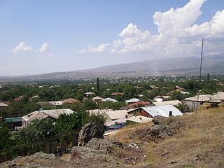
Bjni, is a village in the Kotayk Province of Armenia. It is situated in a valley between canyon walls and a small river. The village is one of the prominent centers of education and culture of ancient and medieval Armenia. It is the birthplace of the 11th-century scholar Grigor Magistros.
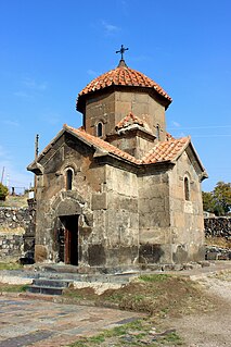
Karmravor, also known as the Church of Holy Mother of God is a 7th-century Armenian Apostolic church in the town of Ashtarak in the Aragatsotn Province.

Arzakan, is a village in the Kotayk Province of Armenia. The Aghveran resort is located in Arzakan. There are the large ruins of the 10th- or 11th-century Neghutsi Vank, located along a ravine to the northwest of the village. There are also the 13th-century monastic ruins of Ghuki Vank and 13th-century ruins of Surb Gevorg in the vicinity.
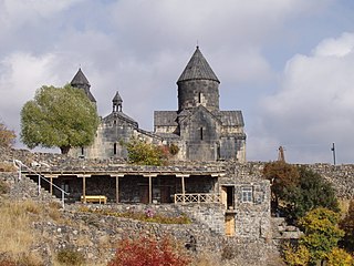
Tegher Monastery is an early 13th-century Armenian monastery and church located on the southeastern slopes of Mount Aragats near the modern village of Tegher, and across the gorge from the village of Byurakan in the Aragatsotn Province of Armenia. It was built for Princess Khatun, the wife of Prince Vache I Vachutian who had purchased the district of Aragatzotn from the Zakarian brothers. The architect Vardapet Aghbayrik designed Tegher and the monasteries of Saghmosavank and Hovhannavank during the 13th century. The monastery survived intact during a time when Mongol invasions plagued the lands.

Yeghipatrush, is a village in the Aragatsotn Province of Armenia. During the Soviet period, the town was renamed in honor of Askanaz Mravyan, Soviet Armenian Cultural Commissar. The town has a 10th- to 13th-century church of Surb Astvatsatsin. Some 100 meters beyond the church is an early cemetery with one corner of an allegedly 5th-century basilica as well as a khachkar shrine.

Koghb, is a major village and rural community located in the Tavush Province of Armenia, located near the town of Noyemberyan.

Shenik is a former settlement and an abandoned village in the Aragatsotn Province of Armenia. It is 3 km east of the Mastara village, and is home to the 5th-century church of Surp Amenaprkich, and the 7th-century church of Surp Astvatsatsin.
Makravank is an Armenian church-complex located in the Makravan district of Hrazdan, the capital of Kotayk Province, Armenia. The monastic complex includes a half-ruined 11th-century chapel. The 13th-century church dedicated to Surb Astvatsatsin has a circular tambour and a conical cupola. The complex also includes the lower walls of the gavit and a medieval cemetery.

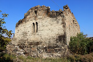
The Cathedral of Talin is a seventh-century Armenian cathedral located in the cemetery of Talin, in the Aragatsotn Province of Armenia.
Spitakavor Church ; literally meaning white-colored church, is a 13th-century partly ruined Armenia church located at the edge of a gorge in the town of Ashtarak, Aragatsotn Province, Armenia.
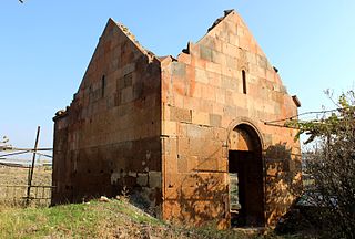
Tsiranavor Church ; literally meaning apricot-colored church is a 5th-century partly ruined Armenian church located at the edge of a gorge in the town of Ashtarak, Aragatsotn Province, Armenia.

Kotavank is a church located on a hill overlooking the Argitchi River and village of Nerkin Getashen, south of Lake Sevan in the Gegharkunik Province of Armenia. A large medieval cemetery surrounds the church with numerous khachkars. A modern cemetery adjacent has started to encroach upon the old one, leaving many of the khachkars and ancient tombstones upturned in a pile, moved from their original locations. Upon a hill adjacent to the modern cemetery is yet another ancient cemetery with many khachkars. Within the village is a small ruined basilica called "Jam" by the locals with ancient khachkars and tombstones built into its walls, and not far away is a small shrine. There are also two large stone forts from the Middle Ages located 2 km to the east and 3 km the west of the village. Other khachkars may be seen along the main road leading to the hill where Kotavank rests upon. In early medieval years it was the capital of the region known during that time as Kot. Both Kotavank and Kot were partially destroyed during invasions in the 10th and 11th centuries and later by an earthquake.

The Surb Astvatsatsin Church ; also Yeghipatrush Church is a church located in the village of Yeghipatrush in the Aragatsotn Province of Armenia. It was constructed between the 10th and 13th centuries.

Jukhtak Vank is an 11th– or 12th-century monastery situated in a clearing within Dilijan National Park, 3.2 km northwest from the town of Dilijan in the Tavush Province of Armenia. It sits in close proximity to the church of Matosavank as well as a cemetery that surrounds the church.
Matosavank is 13th-century small Armenian monastery, hidden in a forested area of Dilijan National Park 3 km northwest from the town of Dilijan in the Tavush Province of Armenia. It sits in close proximity to the monastery of Jukhtak Vank as well as to a nearby cemetery. The church is currently in ruin and is relatively difficult to find since trail markers are often misleading.

Neghuts Monastery is a monastery founded in the 10th or 11th century, situated in a clearing on a hillside overlooking a valley and the village of Arzakan in the Kotayk Province of Armenia. The monastery is located approximately 2 kilometres (1.2 mi) northwest of the village center. There are other churches in the vicinity, most notably the 13th-century monastic/church ruins of Ghuki Vank, the church ruins of S. Astvatsatsin (1207), and the 13th-century ruins of Surb Gevorg.
Saint or Surp Astvatsatsin Church may refer to: