
Cappadocia is a historical region in Central Anatolia, Turkey. It is largely in the provinces of Nevşehir, Kayseri, Aksaray, Kırşehir, Sivas and Niğde.

Nevşehir Province is a province in central Turkey with its capital in Nevşehir. Its area is 5,485 km2, and its population is 310,011 (2022). Its adjacent provinces are Kırşehir to the northwest, Aksaray to the southwest, Niğde to the south, Kayseri to the southeast, and Yozgat to the northeast. Nevşehir includes the area called Cappadocia - a tourist attraction in Turkey. The town of Göreme is also located in Nevşehir.

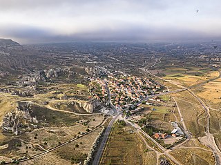
Göreme is a town (belde) in the Nevşehir District, Nevşehir Province in Central Anatolia, Turkey. Its population is 2,034 (2022). It is well known for its fairy chimneys, eroded rock formations, many of which were hollowed out in the Middle Ages to create Christian churches, houses and underground cities. Göreme was formerly known as Korama, Matiana, Macan and Avcilar.

Niğde Province is a province in the southern part of Central Anatolia, Turkey. Its area is 7,234 km2, and its population is 365,419 (2022) of which 170,511 live in the city of Niğde. The population was 348,081 in 2000 and 305,861 in 1990. Neighbouring provinces are Kayseri, Adana, Mersin, Konya, Aksaray and Nevşehir.

Göreme Historical National Park is a national park in central Turkey. It occupies an area of nearly 100 km2 and is located in Nevşehir Province. It became a UNESCO World Heritage Site in 1985 under the name Goreme National Park and the Rock Sites of Cappadocia. The park features a rocky, water- and wind-eroded landscape with a network of ancient, interconnecting underground settlements.

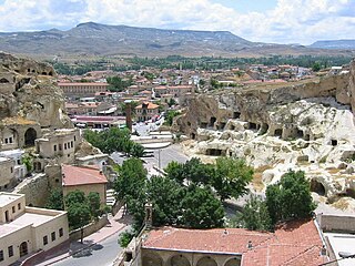
Nevşehir is a city in the Central Anatolia Region of Turkey. It is the seat of Nevşehir Province and Nevşehir District. Its population is 123,882 (2022). It is 290 km (180 mi) from the capital Ankara and lies within the historical region of Cappadocia.

Gülşehir, formerly Aravissos and Arapsun, ancient Zoropassos, is a town in Nevşehir Province in the Central Anatolia region of Turkey, in the vicinity of the Fairy Chimney valley of Göreme. It is the seat of Gülşehir District. Its population is 12,474 (2022). Its elevation is 885 m (2,904 ft).
Derinkuyu is a town in Nevşehir Province in the Central Anatolia region of Turkey. It is the seat of Derinkuyu District. Its population is 10,912 (2022). The elevation is 1,333 m (4,373 ft).
Ürgüp is a town in Nevşehir province in the Cappadocia area of Central Anatolia, Turkey. It is the seat of Ürgüp District. Its population is 24,647 (2022). The town lies at an average elevation of 1,044 m (3,425 ft).
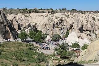
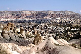
Göreme is a district of the Nevşehir Province in Turkey. After the eruption of Mount Erciyes about 2.6 million years ago, ash and lava formed soft rocks in the Cappadocia region, covering a region of about 20,000 square kilometres (7,700 sq mi). The softer rock was eroded by wind and water, leaving the hard cap rock on top of pillars, forming the present-day fairy chimneys. People of Göreme, at the heart of the Cappadocia region, realized that these soft rocks could be easily carved out to form houses, churches, and monasteries. These Christian sanctuaries contain many examples of Byzantine art from the post-iconoclastic period. These frescos are a unique artistic achievement from this period.

Özkonak Underground City is an ancient city built into the northern slopes of Mt. Idis about 14 km northeast of Avanos in Nevşehir Province, in the Central Anatolia region of Turkey.
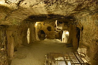
Kaymakli Underground City is contained within the citadel of Kaymakli in the Central Anatolia Region of Turkey. First opened to tourists in 1964, the village is about 19 km from Nevşehir, on the Nevşehir-Niğde road.

Derinkuyu also known as Elengubu, Cappadocian Greek: Μαλακοπή Malakopi; Turkish: Derinkuyu Yeraltı Şehri) is an ancient multi-level underground city near the modern town of Derinkuyu in Nevşehir Province, Turkey, extending to a depth of approximately 85 metres (280 ft). It is large enough to have sheltered as many as 20,000 people together with their livestock and food stores. It is the largest excavated underground city in Turkey and is one of several underground complexes found throughout Cappadocia.

The Zelve Monastery is a Byzantine-era monastery that was carved into the rock in pre-iconoclastic times. It is part of the Zelve Open Air Museum, located between Ürgüp and Avanos, Turkey.
The Kayakapi neighbourhood of Ürgüp, Turkey is a historical area located on the northeastern slope of a hill known as Esbelli. It features many examples of vernacular and monumental architecture, including the House of Saint John the Russian (Yuhannes). Abandoned after the 1980s, the semi-ruins and natural landscape of Kayakapi are now being developed for tourism.
Çavuşin is a village in the Avanos District in Nevşehir Province in the Cappadocia region of Turkey. Its population is 421 (2022). It is on the road between Avanos and Göreme, about five kilometres north of Göreme. The older part of the village lies on and around a large ridge of rock visible for miles around. Most of the modern homes are closer to the main road where villagers were rehoused in the early 1960s amid fears that their old homes might collapse. Until recently Çavuşin was more or less ignored by tourism despite its proximity to the Göreme honeypot. However, in the 2010s more hotels opened in Cavuşin too, especially in the older part of the village.
Runfire Cappadocia Ultramarathon, shortly RFC, is an international multiday ultramarathon event of desert concept that takes place mostly across the historic Cappadocia region in central Turkey. The event is run 244 km (152 mi) in the provinces Nevşehir and Aksaray in six days. The Runfire Cappadocia Ultramarathon was established in 2012 taking place on July 7–15. It is considered a race of high-degree difficulty. The event is organized by Argos Culture & Arts.
Üzümlü Church is a 7th-century church located in the Zelve Valley in Central Anatolia. The church itself is classified as a "fairy chimney formation". This church is considered one of the most important historic churches in Zelve, along with Balıklı Kilise and Haçlı Kilise. It is located in Cappadocia's Red Valley, near the town of Ortahisar. The walls of the church are decorated with red and green painted grapevines and a cross is carved into the ceiling. Located nearby is the Valley of the Monks which is full of distinctive fairy chimney rock formations.
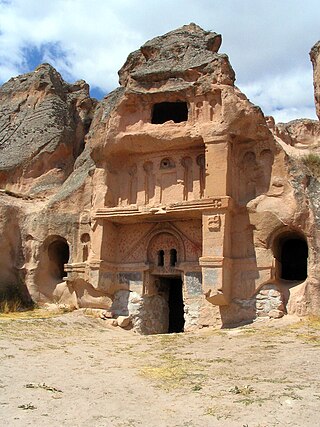
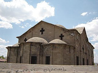
Rock-cut architecture in Cappadocia in Central Turkey includes living and work spaces as well as sacred buildings like churches and monasteries, that were carved out of the soft tuff landscape.
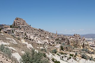
Uçhisar is a town (belde) in the Nevşehir District, Nevşehir Province in Cappadocia, Turkey. Its population is 3,555 (2022). It is 7 kilometres east of Nevşehir, 12 kilometres west of Ürgüp, and 10 kilometres south of Avanos.


