Awathahi Basant

Last updated

Awathahi Basant
Village
India Uttar Pradesh location map.svg
Red pog.svg
Awathahi Basant
Location in Uttar Pradesh, India
India location map.svg
Red pog.svg
Awathahi Basant
Awathahi Basant (India)
Coordinates: 25°37′06″N83°51′06″E / 25.618262°N 83.851781°E / 25.618262; 83.851781
CountryFlag of India.svg  India
State Uttar Pradesh
District Ghazipur
Tehsil Mohammadabad
Government
  Type Panchayati raj (India)
  Body Gram panchayat
Languages
  Official HIndi
  Other spoken Bhojpuri
Time zone UTC+5:30 (IST)
Pin code
233227 [1]
Telephone code 05493
Vehicle registration UP-61
Website up.gov.in

Awathahi is village located in Mohammadabad tehsil of Ghazipur district, Uttar Pradesh, India. Its 703 households gave it a population of 4,597 at the 2011 Census of India. [2]

Administration

Awathahi Basant village is administered by Pradhan who is an elected representative of the village as per the constitution of India and Panchyati Raaj Act.

ParticularsTotalMaleFemale
Total No. of Houses703
Population459723052292

Related Research Articles

<span class="mw-page-title-main">Balagarh (community development block)</span> Community Development Block in West Bengal, India

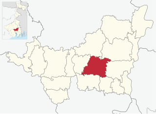
Balagarh is a Community Development Block, located in Jirat, West Bengal, India, that forms an administrative division in Chinsurah Subdivision of Hooghly in the Indian state of West Bengal

<span class="mw-page-title-main">Murarai I</span> Community development block in West Bengal, India

Murarai I is a community development block that forms an administrative division in Rampurhat subdivision of Birbhum district in the Indian state of West Bengal.

<span class="mw-page-title-main">Haripal (community development block)</span> Community development block in West Bengal, India

Haripal is a community development block that forms an administrative division in Chandannagore subdivision of Hooghly district in the Indian state of West Bengal.

<span class="mw-page-title-main">Khanakul I</span> Community development block in West Bengal, India

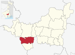
Khanakul I is a community development block that forms an administrative division in Arambag subdivision of Hooghly district in the Indian state of West Bengal.

<span class="mw-page-title-main">Chanditala II</span> Community development block in West Bengal, India

Chanditala II is a community development block that forms an administrative division in Srirampore subdivision of Hooghly district in the Indian state of West Bengal.

<span class="mw-page-title-main">Jangipara (community development block)</span> Community development block in West Bengal, India

Jangipara is a community development block that forms an administrative division in Srirampore subdivision of Hooghly district in the Indian state of West Bengal.

<span class="mw-page-title-main">Polba Dadpur</span> Community development block in West Bengal, India

Polba Dadpur is a community development block that forms an administrative division in Chinsurah subdivision of Hooghly district in the Indian state of West Bengal.

<span class="mw-page-title-main">Khoyrasol (community development block)</span> Community development block in West Bengal, India

Khayrasol is a community development block that forms an administrative division in Suri Sadar subdivision of Birbhum district in the Indian state of West Bengal.

<span class="mw-page-title-main">Beldanga I</span> Community development block in West Bengal, India

Beldanga I is a community development block that forms an administrative division in the Berhampore subdivision of Murshidabad district in the Indian state of West Bengal.

<span class="mw-page-title-main">Khanakul II</span> Community development block in West Bengal, India

Khanakul II is a community development block that forms an administrative division in Arambag subdivision of Hooghly district in the Indian state of West Bengal.

<span class="mw-page-title-main">Chinsurah Mogra</span> Community development block in West Bengal, India

Chinsurah Mogra is a community development block that forms an administrative division in Chinsurah subdivision of Hooghly district in the Indian state of West Bengal.

<span class="mw-page-title-main">Pandua (community development block)</span> Community development block in West Bengal, India

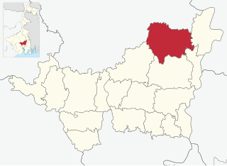
Pandua is a community development block that forms an administrative division in Chinsurah subdivision of Hooghly district in the Indian state of West Bengal.

<span class="mw-page-title-main">Chanditala I</span> Community development block in West Bengal, India

Chanditala I is a community development block that forms an administrative division in Srirampore subdivision of Hooghly district in the Indian state of West Bengal.

<span class="mw-page-title-main">Sreerampur Uttarpara</span> Community development block in West Bengal, India

Sreerampur Uttarpara is a community development block that forms an administrative division in Srirampore subdivision of Hooghly district in the Indian state of West Bengal.

<span class="mw-page-title-main">Dubrajpur (community development block)</span> Community development block in West Bengal, India

Dubrajpur is a community development block that forms an administrative division in Suri Sadar subdivision of Birbhum district in the Indian state of West Bengal.

<span class="mw-page-title-main">Bolpur Sriniketan</span> Community development block in West Bengal, India

Bolpur Sriniketan is a community development block that forms an administrative division in Bolpur subdivision of Birbhum district in the Indian state of West Bengal.

<span class="mw-page-title-main">Labpur (community development block)</span> Community development block in West Bengal, India

Labpur is a community development block that forms an administrative division in Bolpur subdivision district of Birbhum district in the Indian state of West Bengal.

<span class="mw-page-title-main">Murarai II</span> Community development block in West Bengal, India

Murarai II is a community development block that forms an administrative division in Rampurhat subdivision of Birbhum district in the Indian state of West Bengal.

<span class="mw-page-title-main">Nalhati II</span> Place in West Bengal, India

Nalhati II is a community development block that forms an administrative division in Rampurhat subdivision of Birbhum district in the Indian state of West Bengal.

References

  1. "Pin Code, Awathahi". pincode.net.in. Retrieved 6 June 2017.
  2. "Population details, Awathahi". Office of the Registrar General & Census Commissioner, India. Retrieved 6 June 2017.