Babimost

Last updated • 4 min readFrom Wikipedia, The Free Encyclopedia
Babimost
Babimost, Ratusz - fotopolska.eu (141284).jpg
Town center with the town hall
POL Babimost flag.svg
POL Babimost COA.svg
Poland adm location map.svg
Red pog.svg
Babimost
Coordinates: 52°09′53″N15°49′40″E / 52.16472°N 15.82778°E / 52.16472; 15.82778
Country Flag of Poland.svg  Poland
Voivodeship POL wojewodztwo lubuskie flag.svg  Lubusz
County Zielona Góra
Gmina Babimost
Town rights1397
Government
[1]
  MayorBernard Radny
Area
[2]
  Total
3.65 km2 (1.41 sq mi)
Population
 (30 June 2022) [3] [4]
  Total
3,848
  Density1,054/km2 (2,730/sq mi)
Time zone UTC+1 (CET)
  Summer (DST) UTC+2 (CEST)
Postal code [5]
66-110
Area code [6] +48 68
Car plates [7] FZI
Climate Dfb
Primary airport Zielona Góra Airport
Website babimost.pl

Babimost [baˈbʲimɔst] (German : Bomst) is a town in Zielona Góra County, Lubusz Voivodeship, western Poland. It is the administrative seat of Gmina Babimost. Babimost has an area of 3.65 square kilometres (1.41 square miles), [2] and as of June 2022 it has a population of 3,848. [3]

Contents

Geography

The town is situated on the Leniwa Obra creek, about 20 km (12 mi) northeast of Sulechów and about 75 km (47 mi) west of Poznań. Though located in Lubusz Voivodeship, Babimost is part of the Greater Poland historical region.[ citation needed ]

History

Baroque St. Lawrence Church Babimost, Kosciol sw. Wawrzynca - fotopolska.eu (123631).jpg
Baroque St. Lawrence Church

The territory became a part of the emerging Polish state under its first historic ruler Mieszko I in the 10th century. The settlement probably arose about 1000 AD around a castellany located at a crossing through the swampy Leniwa Obra river. The estates were held by the Pomeranian Swienca family until 1307; together with nearby Sulechów, they were acquired by Margrave Waldemar of Brandenburg in 1319, who nevertheless died in the same year. By 1329, they were held by the Silesian duke Henry IV the Faithful, then a Bohemian vassal. Finally incorporated into the Polish Poznań Voivodeship in 1332 (which was later also part of the larger Greater Poland Province), Babimost received town privileges according to Magdeburg Law by King Władysław II Jagiełło in 1397. It was a royal town of Poland. King Sigismund the Old confirmed the city rights in 1530.[ citation needed ]

After the Protestant Reformation, the population increased due to the influx of German-speaking refugees from Silesia. Oppressed by the Catholic Habsburg rule, they were granted religious freedom by Polish king John II Casimir Vasa. [8] In the mid-17th century, the starost of Babimost was Krzysztof Żegocki, who during the Swedish invasion of Poland was the first to organize a guerrilla unit to fight the invading forces and became famous in the battles of Kościan and Jasna Góra, thus earning the title of the "First Partisan of the Commonwealth". [9] During the war, which was part of the Second Northern War, Babimost was devastated by Swedish troops in 1656. The reconstruction of a synagogue is documented around 1700, a Protestant church was erected in 1782. The inhabitants were mainly shoe manufacturers, linen producers and hop (beer) and wine producers.[ citation needed ]

Upon the Second Partition of Poland in 1793, the town fell to Prussia. After the successful Greater Poland uprising of 1806, it was regained by the Poles and included within the short-lived Duchy of Warsaw. At the Congress of Vienna in 1815, it again passed to Prussia, and was incorporated into the Grand Duchy of Posen. Prussians conducted a policy of Germanisation towards the local population. [9] German was introduced in Polish schools, German colonists were settled to change the ethnic composition. [9] Between 1818 and 1938 it was part of the Bomst district within the Prussian Regierungsbezirk Posen , though the administrative seat was at Wollstein (Wolsztyn). When the town became part of the German Empire in 1871, it had 2,272 inhabitants, of whom 1,042 were Catholics (mostly Poles), 1,070 were Protestants (mostly Germans) and 160 Jewish. Despite attempts at Germanisation, Poles founded new organizations in the town, including an agricultural association (Kółko Rolnicze), People's Bank (Bank Ludowy) and the Catholic Association of Polish Youth (Katolicki Związek Młodzieży Polskiej). [9]

A memorial stone dedicated to the Greater Poland insurgents and heroes of the fight for liberation of the Babimost land until 1945 Obeliks w Parku w Babimoscie..jpg
A memorial stone dedicated to the Greater Poland insurgents and heroes of the fight for liberation of the Babimost land until 1945

After Poland regained independence in 1918, Poles from the town and the surrounding area actively joined the Greater Poland Uprising to rejoin the area with Poland. [9] On January 24, 1919, the insurgents captured Babimost, but under the Treaty of Versailles the town remained within Germany. [9] In the interwar period, the town lay on the border with the Second Polish Republic; remaining with the German province of Posen-West Prussia and from 1938 to 1945 as part of the Province of Brandenburg. The majority of the town's population was German-speaking, while up to a third of its residents were Poles. Attempts at Germanisation intensified, in response Poles set up private schools, gathered in theater groups and choirs, Polish press was spreading, and Polish organizations were active. [9] In 1939, 1,950 inhabitants were registered as citizens of the town, of whom 600 were ethnic Polish. During the German invasion of Poland, in September 1939, the Germans arrested several regional Polish activists (including local Polish leader Jan Cichy), [9] who were then deported to Nazi concentration camps, and later also expelled several Polish families from the county. [10]

After the Vistula–Oder Offensive of the Red Army in the late days of World War II, large parts of the town lay in ruins. In 1945, Babimost was reintegrated with Poland and its German inhabitants were to be expelled by the new administration in accordance with the Potsdam Agreement. However, with Polish and German ethnicities coexisting over centuries, no clear division between Poles and Germans could be made, so that the majority of those who were to be expelled, could stay by renouncing any German language and culture. [8]

Transport

Babimost railway station Babimost, Stacja kolejowa Babimost - fotopolska.eu (135993).jpg
Babimost railway station

Voivodeship roads 303, 304 and 313 pass through the town. There is a railway station in Babimost and the Zielona Góra Airport is located nearby.

Demographics

Historical population
YearPop.±%
18432,278    
18712,272−0.3%
18802,179−4.1%
18902,341+7.4%
19002,123−9.3%
19102,000−5.8%
YearPop.±%
19251,782−10.9%
19392,190+22.9%
19501,729−21.1%
19602,584+49.5%
20104,196+62.4%
Source: [11] [12]

Sports

The local football club is Klon Babimost. [13] It competes in the lower leagues.

The local floorball club is Fenomen Babimost.

International relations

Twin towns – sister cities

See twin towns of Gmina Babimost.

See also

Related Research Articles

<span class="mw-page-title-main">Zielona Góra</span> City in Lubusz Voivodeship, Poland

Zielona Góra is the largest city in Lubusz Voivodeship, located in western Poland, with 140,403 inhabitants (2021). The region is closely associated with vineyards and holds an annual Wine Fest. Zielona Góra is one of the two capital cities of Lubusz Voivodeship, hosting the province's elected assembly, while the seat of the centrally appointed governor is in the city of Gorzów Wielkopolski.

<span class="mw-page-title-main">Lubusz Voivodeship</span> Voivodeship in Western Poland

Lubusz Voivodeship is a voivodeship (province) in western Poland.

<span class="mw-page-title-main">Augustów</span> Town in Podlaskie Voivodeship, Poland

Augustów is a town in north-eastern Poland. It lies on the Netta River and the Augustów Canal. It is the seat of Augustów County and of Gmina Augustów in the Podlaskie Voivodeship. Augustów has an area of 80.90 square kilometres, and as of June 2022 it has a population of 29,305.

<span class="mw-page-title-main">Andrychów</span> Town in Lesser Poland Voivodeship, Poland

Andrychów is the largest town in Wadowice County, Lesser Poland Voivodeship, Poland. The town is located in the Little Beskids, in the historical region of Lesser Poland, on the river Wieprzówka. It has been situated in the Lesser Poland Voivodeship since 1999, having previously been located in the Bielsko-Biała Voivodeship (1975–1998). Andrychów has an area of 10.34 square kilometres and as of June 2022 it has 271,815 inhabitants.

<span class="mw-page-title-main">Alwernia</span> Town in Lesser Poland Voivodeship, Poland

Alwernia is a town situated some 36 kilometres west of Kraków in the Chrzanów County, Lesser Poland Voivodeship, Poland. The town has an area of 8.88 square kilometres, and as of June 2022 it has a population of 3,284.

<span class="mw-page-title-main">Aleksandrów Łódzki</span> Town in Łódź Voivodeship, Poland

Aleksandrów Łódzki is a town in Zgierz County, Łódź Voivodeship, Poland. It is a part of the Łódź agglomeration. Aleksandrów Łódzki has an area of 13.82 square kilometres, and as of June 2022 its population was 22,160.

<span class="mw-page-title-main">Zielona Góra County</span> County in Lubusz Voivodeship, Poland

Zielona Góra County is a unit of territorial administration and local government (powiat) in Lubusz Voivodeship, western Poland. It came into being on January 1, 1999, as a result of the Polish local government reforms passed in 1998. Its administrative seat is the city of Zielona Góra, although the city is not part of the county. The county contains five towns: Sulechów, which lies 23 km (14 mi) north-east of Zielona Góra, Nowogród Bobrzański, which lies 25 km (16 mi) south-west of Zielona Góra, Babimost, which lies 40 km (25 mi) north-east of Zielona Góra, Czerwieńsk, which lies 11 km (7 mi) north-west of Zielona Góra, and Kargowa, 40 km (25 mi) north-east of Zielona Góra.

<span class="mw-page-title-main">Posen–West Prussia</span> Prussian province created in 1922

The Frontier March of Posen–West Prussia was a province of Prussia from 1920/1922 to 1938, covering most of lands of historical Greater Poland that were not included in the Second Polish Republic. Posen–West Prussia was established in 1922 as a province of the Free State of Prussia within Weimar Germany, formed from merging three remaining non-contiguous territories of Posen and West Prussia, which had lost the majority of their territory to the Second Polish Republic following the Greater Poland Uprising. From 1934, Posen–West Prussia was de facto ruled by Brandenburg until it was dissolved by Nazi Germany, effective 1 October 1938 and its territory divided between the provinces of Pomerania, Brandenburg and Silesia. Schneidemühl was the provincial capital. Today, lands of the province are entirely contained within Poland.

<span class="mw-page-title-main">Wolsztyn</span> Place in Greater Poland Voivodeship, Poland

Wolsztyn is a town in western Poland, on the western edge of Greater Poland Voivodeship. It is the seat of Wolsztyn County, and of the smaller administrative district of Gmina Wolsztyn.

<span class="mw-page-title-main">Aleksandrów Kujawski</span> Town in Kuyavian-Pomeranian Voivodeship, Poland

Aleksandrów Kujawski is a town in north-central Poland, in Kuyavian-Pomeranian Voivodeship. It is the seat of Aleksandrów County, as well as of Gmina Aleksandrów Kujawski. It is situated about 18 km (11 mi) south-east of Toruń. As of December 2022 Aleksandrów Kujawski has an area of 7.23 km2 (2.79 sq mi) and a population of 11,536.

<span class="mw-page-title-main">Annopol</span> Town in Lublin Voivodeship, Poland

Annopol is a town in south-eastern Poland, located in Kraśnik County in Lublin Voivodeship, in the historic region of Lesser Poland. Annopol has an area of 7.73 square kilometres, and as of June 2022 it has 2,335 inhabitants.

<span class="mw-page-title-main">Baborów</span> Town in Opole Voivodeship, Poland

Baborów is a town in Gmina Baborów, Głubczyce County, Opole Voivodeship, southern Poland. The town has an area of 11.86 square kilometres, and as of June 2022 it has a population of 2,852. Baborów lies on the river Psina.

<span class="mw-page-title-main">Skwierzyna</span> Place in Lubusz Voivodeship, Poland

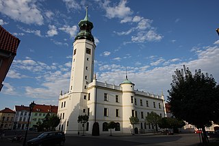
Skwierzyna is a town in Lubusz Voivodeship in western Poland, serving as the administrative seat of the Gmina Skwierzyna. As of 31 December 2023, it had a population of 9,078 inhabitants. It is located at the confluence of the Obra and Warta rivers, about 18 km (11 mi) north of Międzyrzecz and 23 km (14 mi) south-east of the regional capital Gorzów Wielkopolski. The town is situated in a particularly green part of Poland. Extensive forests and numerous lakes can be found in the vicinity.

<span class="mw-page-title-main">Biskupiec</span> Place in Warmian-Masurian Voivodeship, Poland

Biskupiec is a town in northern Poland, in Warmia, in the Warmian-Masurian Voivodeship. It is located in Olsztyn County and, as of December 2021, it has a population of 10,496. The countryside surrounding Biskupiec is a popular tourist destination, part of the Masurian Lake District.

<span class="mw-page-title-main">Sulechów</span> Place in Lubusz Voivodeship, Poland

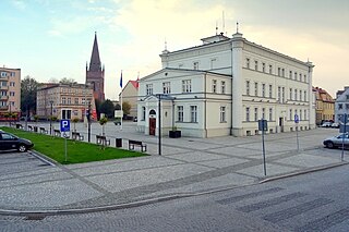
Sulechów is a town located within the Zielona Góra County, in Lubusz Voivodeship, western Poland. It is the administrative seat of the Gmina Sulechów. Established in the Middle Ages, the town features many historical monuments significant to the Polish Lubusz region. The town limits cover 6.83 square kilometres (2.64 sq mi).

<span class="mw-page-title-main">Czerwieńsk</span> Place in Lubusz Voivodeship, Poland

Czerwieńsk is a town in Zielona Góra County, Lubusz Voivodeship, in western Poland, with 3,900 inhabitants as of December 2021. Czerwieńsk is a railroad junction, where the Wrocław – Zielona Góra – Szczecin connection meets the line to Poznań.

<span class="mw-page-title-main">Gmina Sulechów</span> Gmina in Lubusz Voivodeship, Poland

Gmina Sulechów is an urban-rural gmina in Zielona Góra County, Lubusz Voivodeship, in western Poland. Its seat is the town of Sulechów, which lies approximately 18 kilometres (11 mi) north-east of Zielona Góra.

<span class="mw-page-title-main">Pszczew</span> Village in Lubusz Voivodeship, Poland

Pszczew is a village in Międzyrzecz County, Lubusz Voivodeship, in western Poland. It is the seat of the gmina called Gmina Pszczew. It lies approximately 13 kilometres (8 mi) east of Międzyrzecz, 46 km (29 mi) south-east of Gorzów Wielkopolski, and 62 km (39 mi) north of Zielona Góra. It is situated between the Kochle and Szarcz lakes.

<span class="mw-page-title-main">Nowe Kramsko</span> Village in Lubusz Voivodeship, Poland

Nowe Kramsko is a village in the administrative district of Gmina Babimost, within Zielona Góra County, Lubusz Voivodeship, in western Poland. It lies approximately 4 kilometres (2 mi) south-west of Babimost and 28 km (17 mi) north-east of Zielona Góra. It is situated on the northern shore of Lake Wojnowskie.

<span class="mw-page-title-main">Klępsk</span> Village in Lubusz Voivodeship, Poland

Klępsk is a village in the administrative district of Gmina Sulechów, within Zielona Góra County, Lubusz Voivodeship, in western Poland. It lies approximately 8 kilometres (5 mi) east of Sulechów and 23 km (14 mi) north-east of Zielona Góra.

References

  1. "Burmistrz" [Mayor]. bip.wrota.lubuskie.pl (in Polish). Urząd Miejski w Babimoście. Retrieved 31 January 2023.
  2. 1 2 "Local Data Bank". bdl.stat.gov.pl. Statistics Poland. Retrieved 6 March 2023. Category K1, group G441, subgroup P1410. Data for territorial unit 0809014.
  3. 1 2 "Local Data Bank". bdl.stat.gov.pl. Statistics Poland. Retrieved 6 March 2023. Category K3, group G7, subgroup P1336. Data for territorial unit 0809014.
  4. "Local Data Bank". bdl.stat.gov.pl. Statistics Poland. Retrieved 6 March 2023. Category K3, group G7, subgroup P2425. Data for territorial unit 0809014.
  5. "Oficjalny Spis Pocztowych Numerów Adresowych" (PDF). poczta-polska.pl (in Polish). Poczta Polska. pp. 9, 1655. Retrieved 20 February 2023.
  6. Rozporządzenie Ministra Administracji i Cyfryzacji z dnia 30 października 2013 r. w sprawie planu numeracji krajowej dla publicznych sieci telekomunikacyjnych, w których świadczone są publicznie dostępne usługi telefoniczne, Dz. U., 2013, No. 1281 (2013-10-30)
  7. Rozporządzenie Ministra Infrastruktury z dnia 31 sierpnia 2022 r. w sprawie rejestracji i oznaczania pojazdów, wymagań dla tablic rejestracyjnych oraz wzorów innych dokumentów związanych z rejestracją pojazdów, Dz. U., 2022, No. 1847 (2022-08-31)
  8. 1 2 Vogenbeck, Bernd; Tomann, Juliane; Abraham-Diefenback, Magda (2008). Terra Transoderana - Zwischen Neumark und Ziemia Lubuska (in German). Berlin-Brandenburg: Bebra. ISBN   9783937233505.
  9. 1 2 3 4 5 6 7 8 "Historia / Babimost". Powiat Zielonogórski - Starostwo Powiatowe w Zielonej Górze (in Polish). Retrieved 10 October 2019.
  10. Cygański, Mirosław (1984). "Hitlerowskie prześladowania przywódców i aktywu Związku Polaków w Niemczech w latach 1939–1945" (PDF). Przegląd Zachodni (in Polish). No. 4. Opole. pp. 49–50. ISSN   0033-2437 . Retrieved 31 January 2023.
  11. Dokumentacja Geograficzna (in Polish). Vol. 3/4. Warszawa: Instytut Geografii Polskiej Akademii Nauk. 1967. p. 1.
  12. Stan i struktura ludności oraz ruch naturalny w przekroju terytorialnym w 2010 r. (PDF) (in Polish). Warszawa: Główny Urząd Statystyczny. 2011. p. 61. Archived from the original (PDF) on 13 November 2011.
  13. "Oficjalna strona internetowa klubu piłkarskiego LKS Klon Babimost" (in Polish). Klon Babimost. Retrieved 11 June 2020.