
Kanpur, formerly Cawnpore, is a large industrial city located in the central-western part of the state of Uttar Pradesh, India. Founded in 1207, Kanpur became one of the most important commercial and military stations of British India. Kanpur is also the financial capital of Uttar Pradesh. Nestled on the banks of Ganges River, Kanpur has been the major financial and industrial centre of North India and also the ninth-largest urban economy in India. Today it is famous for its colonial architecture, gardens, parks and fine quality leather, plastic and textile products which are exported mainly to the West.

Etawah also known as Ishtikapuri is a city on the banks of Yamuna River in the state of Western Uttar Pradesh in India. It is the administrative headquarters of Etawah District. Etawah's population of 256,838 makes it the one hundred and eightieth-most populous city in India. The city lies 300 km (190 mi) southeast of the national capital New Delhi, and 230 km (140 mi) northwest of the state capital Lucknow.

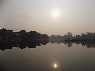
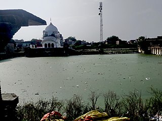
Unnao is a city in the Indian state of Uttar Pradesh. It is the administrative headquarters of Unnao district and a part of Lucknow division, between Kanpur and Lucknow. Unnao is a large industrial city with three industrial suburbs around it. Unnao has the country's largest leather Export in the UPSIDC.such as Mirza International,Model Tannery, Omega Tannery,Model Exim,Calico Trends,Super Tannery,Amin Tannery and Rahman Industries etc.The city is famous for its leather ,Leather Factories, mosquito net, Zardozi and chemical industries. Unnao is an historical city with many historical buildings and structures. Trans Ganga City, a new satellite town of Unnao is being developed in order to develop Unnao as a major industrial and infrastructural hub as the region comes under Kanpur-Lucknow Counter Magnet Area. Unnao district is a part of Central Ganges Plain of the state covering an area of 4558 km2. The city is enlisted as a municipality of Kanpur metropolitan area and is the second largest city within the metropolitan area. nawabganj pakshi vihar located along NH27 is one of best place to see migratory birds which come from various countries during winter season and it has been included in the list of RAMSAR sites. Best time to visit this sanctuary is from November to March.
Orai is a city in Uttar Pradesh, India, and the administrative headquarters of Jalaun District. All administrative offices of Jalaun District, including the District Collectorate, police, telecom and various other government organizations are located in this city. In 2019, Orai received the award of 'Fastest Mover' Small City among India under Swachh Survekshan, an annual cleanliness survey carried by the Quality Council of India.

Unnao district is a district of Uttar Pradesh state in northern India. The city of Unnao is the district headquarters. The district is part of Lucknow Division.

Bangarmau is a big city with Tehsil Bangarmau, in the Unnao district, Uttar Pradesh, India. It is located on high ground overlooking the left bank of the Kalyani river, about 50 km northwest of Unnao and 22 km northwest of Safipur. Roads fan out in all directions from Bangarmau, including the main Unnao-Hardoi road that passes through town. Major commodities produced here include wheat flour, rice, and pulses. As of 2011, the population of Bangarmau is 44,204, in 7,600 households.
Gangaghat is a city and a municipal board in Unnao district in the state of Uttar Pradesh, India. It's Just 12 km from Unnao, 2 km from Kanpur. It is also known as Shuklaganj and is located on the banks of holy river Ganges about 5 km from Kanpur on the SH 58 to Unnao. The population was 70803 as of the 2001 census. According to the census of 2011 it is 84072. It has 91% of literacy and is 5 km from Kanpur Cantonment. Though it lies in Unnao district, it lies adjacent to Kanpur and hence is a suburb of Kanpur. The city is enlisted as a municipality of Kanpur metropolitan area.

Jhinjhak is a town and a Municipal council in Kanpur Dehat district, India. The town is situated on the Lower Ganges Canal and is approximately 20 kilometres (12 mi) from the industrial city of Dibiyapur.
Maudaha is a city and a Municipal Board in Hamirpur district, Uttar Pradesh, India.

Purwa is a town and nagar panchayat in Unnao district, Uttar Pradesh, India. It is located 32 km southeast of Unnao, the district headquarters. Roads connect it with several major cities including Unnao, Lucknow, Kanpur, and Rae Bareli. As of 2011, its population is 24,467 people, in 4,128 households.

Unchahar is a town and nagar panchayat in Raebareli district in the Indian state of Uttar Pradesh. It serves as the headquarters of a tehsil as well as a community development block. It is located on Lucknow Allahabad Highway, 115 km from Lucknow, 85 km from Allahabad. The place is well connected by rail and roads to nearby cities of Kanpur, Lucknow, and Allahabad. Unchahar is also a constituency of Uttar Pradesh Legislative assembly.

Nawabganj is a town and nagar panchayat in Hasanganj tehsil of Unnao district, Uttar Pradesh, India. It is located northeast of Unnao on the Lucknow-Kanpur road, near the Ajgain railway station. Founded in 1842 and first officially classified as a town for the 1981 census, Nawabganj once served as the seat of a tehsil under the Nawabs of Awadh and is today the headquarters of a community development block containing 124 villages.
Kanpur Dehat district is a district in Uttar Pradesh state in northern India. The administrative headquarters of the district are at Mati-Akbarpur. This district is part of Kanpur division. Kanpur was formerly spelled Cawnpore.
Musandi is a village in the Unnao district, in the Indian state of Uttar Pradesh.
Unnao Junction Railway Station, also known as Unnao Railway Station, is a major railway station located in Unnao district in the Indian state of Uttar Pradesh. It serves Unnao and the surrounding areas. The station falls under the jurisdiction of the Northern Railway zone of the Indian Railways and serves as a crucial transportation hub for the region. Unnao Junction railway station is on the Lucknow–Kanpur Suburban Railway and Varanasi–Kanpur branch line.
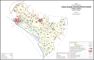
Maharamau is a small village in the Sikandarpur Karan block of Unnao district, Uttar Pradesh, India. As of 2011, its population was 550 in 106 households. It has one primary school and no healthcare facilities.

Madhupur is a census town in Sonbhadra district in the Indian state of Uttar Pradesh. It is located 17 km from Robertsganj which is the administrative headquarters of Sonbhadra District. The district Sonbhadra was created by carving off the southern part of the earlier Mirzapur district on 4 March 1989. Son, Karmnasha, Chandra Prabha, Rihand, Kanhar, Renu, Ghagar and Belan Rivers drain this area. in which Son River in main.
Arkha is a Gram Sabha in Unchahar Tehsil of Raebareli District in Uttar Pradesh State, India. It is 40.15 km away from its district capital Rae Bareli. It is 114 km away from its state capital Lucknow. Its pin code is 229404.
Magarwara is a village in Sikandarpur Karan block of Unnao district, Uttar Pradesh, India. It is located 6 km from the district headquarters, Unnao. It is located on state highways and has one primary school and no healthcare facilities. It has a train station on the Lucknow-Kanpur line, between Kanpur Bridge and Unnao train station; the same stretch of track is also connected with Rae Bareli and Balamau station past Unnao. Magarwara Bone Mill, established in 1927, is one of the major industrial establishments in Unnao district. As of 2011, its population is 6,584, in 1,263 households.
Ajgain is a village in Nawabganj block of Unnao district, Uttar Pradesh, India. It is located northeast of Unnao, near the main Lucknow-Kanpur road. It has a railway station on the Lucknow-Kanpur line, lying between Sonik and Kusumbhi. It holds a market on Mondays and Fridays, with grain and vegetables being the main items of trade. As of 2011, the population of Ajgain is 8,926, in 1,481 households.

