River systems and water resources
The Ganga, Kalyani, and Sai are the main rivers of the district. The Ganga forms the western and southern boundaries, while the Sai largely delineates the northern and eastern boundaries. Other significant rivers in the district include the Kalyani, Tanai, Loni, and Morahi (Naurahi), all of which are tributaries of the Ganga. Although these rivers tend to run dry during the hot weather, they typically hold water for most of the year and are used for irrigation purposes.
Ganga
The only great river of the district is the Ganga, which first touches the district near the village of Purwa Gahir, in pargana Bangarmau, and flows southeastward, acting as a boundary between the districts of Kanpur and Fatehpur. While its general flow direction is from northwest to southeast, the river takes several sharp bends, notably near Umriya Bhagwantpur, Rustampur in tehsil Safipur, Rautapur in tehsil Unnao, and Ratua Khera and Duli Khera in tehsil Purwa. Near Baksar, the Ganga is joined by the Morahi river, flowing close to its old high bank, before leaving the district shortly after Baksar.
The river is not extensively utilized as a waterway or for irrigation purposes. While there are several ferries for pedestrians and pilgrims, none of them can be considered a significant trade route. The river's high banks generally prevent its use for irrigation, but some of its small drainage channels or sotas, which form islands in certain parganas, are occasionally used to irrigate crops in low-lying alluvial lands. Cultivated lands are often located far from the river and cannot be easily irrigated from it. The water from the river would need to pass through the sandy banks, leading to significant loss or absorption. The main channel of the river experiences constant changes, resulting in shifting cultivation practices in its immediate vicinity.
It appears from its old high bank that the river has a general tendency to shift its course to the west. In the days of Akbar, the river skirted the village of Ghatampur but has since then so altered its course that it now runs about 8 km to the southwest of the village.
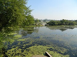
Lakes
The larger lakes of the district, which hold water all the year round, are the Kundra Samundar near Jhalotar, the lake near Nawabganj, the lake near Kantha and the long chain of lakes in pargana Mauranwan. In Tehsil Safipur, the more important lakes are those at Mawai-Bhari and Kursat and the Harial Tal near Mustafabad. In Tehsil Hasanganj, besides the Kundra Samundar at Mawai, there are the Kulli Bani and Jalesar lakes near Ajgain and the chain of lakes called Basaha, travelling a distance of 96 km in the district and eventually leaving it for district Rae Bareli where it is reckoned as a tributary of the river Sai. The Katgari Lake near Asiwan is the western part of the tehsil with the stretches of water at Amarpur, Sambha, Sheothana, Marenda & Asakhera, but in its northern and eastern parts, there are only small and very shallow tanks which dry up when rainfall is deficient. In Tehsil Unnao there are no important lakes, instead a number of very shallow depressions, which get filled up with water during the rains and yield excellent crops of rice.
In Tehsil Purwa there are many lakes, situated in a well-defined belt stretching along the whole length of the tehsil. The main among them are the lakes at Kantha, Bhadain, Unchagaon, Qila, Akhori, Miri, Zorawarganj and Sarwan. The Barhna tank near Sagauli, the Mohan and Sukrar lakes near Mauranwan, and several others, like the Bharda lake, skirt around the district Rae Bareli. Besides these, there are the tanks at Sahrawan, the Bhundi tank at Gulariha, and the Kumbha tank at Bhagwantnagar. The lakes at Kantha, Sagauli, and Barela contain water all the year round, while the others generally provide irrigation for the Rabi crops only, drying up in the years of drought.
Geology
Geologically the district forms part of the vast Indo-Gangetic alluvial tract, of which the origin is attributed to a sag in the Earth's crust, formed, in the upper eocene times, between the northwardly drifting Gondwanaland and the rising Himalayan belt, and gradually filled in by sediments so as to constitute a level plane with a very gentle seaward slope. The alluvium formation of the district, comprising sand, silt and clay with occasional gravel, is of the early quaternary to sub-recent age. The older alluvium called bhangar forms slightly elevated terraces usually above the flood levels. It is rather dark in colour and generally rich in concretions and nodules of impure calcium carbonate, locally known as kankar. The newer alluvium, called khandar, forming the lowlands between the Ganga and Bhangar, is light coloured, poor in calcareous contain and composed of lenticular beds of sand, gravel and clays. The economic minerals found in the district are kankar, reh and sand.