Sikandarpur is a village in Sikandarpur Sarausi block of Unnao district, Uttar Pradesh, India. Located 10 km northwest of the city of Unnao, near the Barhota lake, it serves as the block headquarters as well as the seat of a nyaya panchayat. It is also the namesake of a historical pargana. The main crops in Sikandarpur are wheat, barley, gram, juwar, and paddy, and irrigation is largely done by wells. It has a post office and a veterinary hospital. As of 2011, its population is 4,510, in 752 households.

Bichhiya is a village and corresponding community development block in Unnao district of Uttar Pradesh, India. Located about 16 km southeast of Unnao on the main road to Purwa, it also serves as the seat of a nyaya panchayat and has an Ayurvedic dispensary, a veterinary hospital, an artificial insemination centre, and a family planning centre. The main crops are wheat, gram, barley, juwar, and paddy, and irrigation is largely provided by canal. As of 2011, the village's population is 2,347, in 482 households.

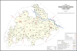
Asoha is a village in Purwa tehsil of Unnao district, Uttar Pradesh, India. It is located about 16 km north of Purwa, the tehsil headquarters, and 51 km east of Unnao, the district headquarters. The main crops grown here are wheat, barley, gram, juwar, paddy, and pulses, and irrigation is provided by a canal as well as by tanks. The soil here is mostly clay. As of 2011, the population of Asoha is 3,709, in 856 households.
Mirri Khurd, also called Kusal Khera, is a village in Asoha block of Unnao district, Uttar Pradesh, India. It has no schools or healthcare facilities. As of 2011, its population is 589, in 109 households.
Chaupai is a village in Asoha block of Unnao district, Uttar Pradesh, India. It has one primary school and no healthcare facilities. As of 2011, its population is 2,548, in 554 households.
Daun is a village in Asoha block of Unnao district, Uttar Pradesh, India. It has one primary school and one medical dispensary. As of 2011, its population is 2,743, in 527 households.
Asawar is a village in Asoha block of Unnao district, Uttar Pradesh, India. It has two primary schools and no healthcare facilities. As of 2011, its population is 3,080, in 572 households.
Bachhaura is a village in Asoha block of Unnao district, Uttar Pradesh, India. It has one primary school and no healthcare facilities. As of 2011, its population is 1,802, in 348 households.
Zorawarganj is a village in Asoha block of Unnao district, Uttar Pradesh, India. It is not connected to major district roads and has two primary schools and no healthcare facilities. As of 2011, its population is 2,553, in 498 households.
Bikamau is a village in Asoha block of Unnao district, Uttar Pradesh, India. It is not connected to major district roads and has one primary school and no healthcare facilities. As of 2011, its population is 1,235, in 246 households.
Jhakwasa is a village in Asoha block of Unnao district, Uttar Pradesh, India. It is not connected to major district roads and has two primary schools and no healthcare facilities. As of 2011, its population is 1,065, in 196 households.
Samadha is a village in Asoha block of Unnao district, Uttar Pradesh, India. It is not connected to major district roads and has two primary schools and no healthcare facilities. As of 2011, its population is 3,681, in 694 households.
Darsawan is a village in Asoha block of Unnao district, Uttar Pradesh, India. It is not connected to major district roads and has two primary schools and two medical practitioners. As of 2011, its population is 3,074, in 600 households.
Utraura is a village in Asoha block of Unnao district, Uttar Pradesh, India. It is not located on major district roads and has one primary school and no healthcare facilities. As of 2011, its population is 1,281, in 281 households.
Soho is a village in Asoha block of Unnao district, Uttar Pradesh, India. It is not located on major roads and has one primary school and no healthcare facilities. As of 2011, its population is 1,675, in 303 households.
Pahasa is a village in Asoha block of Unnao district, Uttar Pradesh, India. It has one primary school and one medical clinic. As of 2011, its population is 1,355, in 271 households.
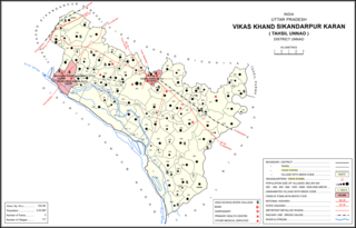
Poni is a village in Sikandarpur Karan block of Unnao district, Uttar Pradesh, India. It is connected to state highways and has 2 primary schools and no healthcare facilities. As of 2011, its population is 1,078, in 289 households.

Sandana is a village in Hilauli block of Unnao district, Uttar Pradesh, India. As of 2011, its population is 6,082, in 1,184 households, and it has 3 primary schools and no healthcare facilities.

Sumerpur is a hamlet of the village Chhanchhi Rai Khera, in Purwa tehsil of Unnao district, Uttar Pradesh, India. Located 26km south of Purwa and 50km southeast of Unnao, Sumerpur serves as the headquarters of a community development block as well as a nyaya panchayat. Sumerpur block was first established on 2 October 1955 in order to oversee implementation of India's Five-Year Plans at a local and rural level. As of 2011, the block comprises 148 villages and has a total population of 151,933 people in 28,469 households.

Rampur Sudauli is a village in Bachhrawan block of Rae Bareli district, Uttar Pradesh, India. One of the main villages in the historical pargana of Bachhrawan, Rampur Sudauli is located at the corner of three districts: Raebareli, Lucknow and Unnao This spot is 15 km from Bachhrawan, at the point where the Sai river first enters the district.