Unnao district is a district of Uttar Pradesh state in northern India. The city of Unnao is the district headquarters. The district is part of Lucknow Division.

Purwa is a town and nagar panchayat in Unnao district, Uttar Pradesh, India. It is located 32 km southeast of Unnao, the district headquarters. Roads connect it with several major cities including Unnao, Lucknow, Kanpur, and Rae Bareli. As of 2011, its population is 24,467 people, in 4,128 households.

Pariyar, also spelled Pariar, is a village in Sikandarpur Sarausi block of Unnao district, Uttar Pradesh, India. It is located on the left bank of the Ganges, 23km northwest of the city of Unnao. Nearby the village is the Mahua lake. Pariyar holds religious significance to Hindus; it is considered to be the place where the goddess Sita was exiled to, and the birthplace of her two sons Lava and Kusha. The village is known for holding a major fair during the month of Kartika, on the day of the full moon, which is attended by over 100,000 people. Historically, Pariyar was the seat of a pargana since 1785, and under the Nawabs of Awadh it was the seat of a tehsildar. Today, it is the headquarters of a nyaya panchayat. Pariyar is connected by road with Mohan and Rasulabad. As of 2011, its population is 7,363, in 1,355 households.
Patan is a town in Sumerpur block of Unnao District in the state of Uttar Pradesh, India. It is located 16km south of Purwa on the main Unnao-Allahabad road, and a short distance to the south of the Loni river. Part of the historical region of Baiswara, it historically gave its name to a pargana which existed since at least the time of Akbar, and under the Nawabs of Awadh it was the seat of a tehsil. The Rae Bareli-Kanpur branch of the Northern Railway zone runs through Patan, and the Takia train station is located in the village. A huge fair called the Takia-ka-Mela is held in Patan on the first Thursday in Paus, in honour of the saint Niamat Shah, revered by both Hindus and Muslims, drawing tens of thousands of visitors. A second fair, established by Muhabbat Shah's disciple Shafqat Shah, is also held in Muhabbat Shah's honour at the tomb on the first Thursday of Jeth.
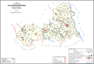
Kurseli is a large village in Hariyawan block of Hardoi district, Uttar Pradesh, India. It is located north of the city of Hardoi, to the west of the main road to Pihani. Kurseli hosts a market on Mondays and Thursdays, and the main staple foods are wheat and rice. It has several schools and one clinic, along with five practitioners of traditional medicine. The village lands extend a long way to the south, and include a chain of jhils that ultimately drain into the Sai river. As of 2011, the population of Kurseli is 10,404, in 1,936 households.
Rau Karna is a village in Sikandarpur Sarausi block of Unnao district, Uttar Pradesh, India. It is located 11 km north of the city of Unnao, on the road to Hardoi. On the east side of the village is the Tinai, a small stream that dries up in hot weather. The village holds a market twice per week. Rau Karna is part of the nyaya panchayat circle of Banda Khera.

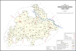
Asoha is a village in Purwa tehsil of Unnao district, Uttar Pradesh, India. It is located about 16 km north of Purwa, the tehsil headquarters, and 51 km east of Unnao, the district headquarters. The main crops grown here are wheat, barley, gram, juwar, paddy, and pulses, and irrigation is provided by a canal as well as by tanks. The soil here is mostly clay. As of 2011, the population of Asoha is 3,709, in 856 households.
Sarwan is a village in Asoha block of Unnao district, Uttar Pradesh, India. It hosts a Deviji mela on Chaitra Badi 8-9 dedicated to the worship of the goddess Devi. Vendors bring agricultural implements, furniture, sweets, toys, and miscellaneous everyday items to sell at the fair. On Chait Krishna 7-8, Sarwan also hosts a market for the Durgaji Ka Mela, where mostly cloths and sweets are sold. Sarwan is located on a major district road and has one primary school and one medical practitioner. As of 2011, its population is 3,824, in 806 households.

Mawai is a village in Hilauli block of Unnao district, Uttar Pradesh, India. As of 2011, its population is 14,690, in 2,734 households, and it has 8 primary schools and one medical clinic. It hosts a regular market and has a post office.

Ajgain is a village in Nawabganj block of Unnao district, Uttar Pradesh, India. It is located northeast of Unnao, near the main Lucknow-Kanpur road. It has a railway station on the Lucknow-Kanpur line, lying between Sonik and Kusumbhi. It holds a market on Mondays and Fridays, with grain and vegetables being the main items of trade. As of 2011, the population of Ajgain is 8,926, in 1,481 households.

Sumerpur is a hamlet of the village Chhanchhi Rai Khera, in Purwa tehsil of Unnao district, Uttar Pradesh, India. Located 26km south of Purwa and 50km southeast of Unnao, Sumerpur serves as the headquarters of a community development block as well as a nyaya panchayat. Sumerpur block was first established on 2 October 1955 in order to oversee implementation of India's Five-Year Plans at a local and rural level. As of 2011, the block comprises 148 villages and has a total population of 151,933 people in 28,469 households.
Sangrampur, also called Daundia Khera, is a village in Sumerpur block of Unnao district, Uttar Pradesh, India. Located on the high bank of the Naurahi river a bit to the west of the main Unnao-Dalmau road, it is most notable for its historic importance as the capital of the Bais of Baiswara. It was the seat of a pargana beginning in the 1700s. As of 2011, its population is 2,778 in 530 households. It has four primary schools and no healthcare facilities.
Bihar is a village in Sumerpur block of Unnao district, Uttar Pradesh, India. Located on the main Unnao-Raebareli road, just to the east of the Loni river and near its confluence with the Kharahi, Bihar was briefly the headquarters of a tehsil in Raebareli district from 1860 until 1862, when it was moved into Unnao district. As of 2011, the population of Bihar is 5,952, in 1,088 households, and it has 5 primary schools and no healthcare facilities.

Makhi is a large village in Miyanganj block of Unnao district, Uttar Pradesh, India. It hosts a Ramlila fair for one day during the month of Kuar, and it also holds a market twice per week, on Mondays and Saturdays. The main items sold at the market are grain and vegetables. Makhi also has a train station on the Kanpur-Balamau line, between the stations at Safipur and Patiyara. As of 2011, its population is 13,786, in 2,503 households.

Tiloi is a Town and tehsil headquarters in Amethi district of Uttar Pradesh, India. Located near Mohanganj on the Jais-Inhauna road, Tiloi is notable as the historical seat of a major taluqdari estate held by the Kanhpurias. As of 2011, its population is 6,956, in 1,257 households.
Simrauta is a village in Tiloi block of Rae Bareli district, Uttar Pradesh, India. It is located at the intersection of the Maharajganj-Inhauna and Mohanganj-Haidargarh roads, about 20 km from Maharajganj, the tehsil headquarters. Although now eclipsed by Maharajganj, Simrauta was historically a relatively important village that served as the headquarters of a pargana and the capital of a branch of the Kanhpuria Rajputs, who later became known as the Rajas of Chandapur. As of 2011, the population of Simrauta is 6,423, in 1,031 households.

Didaur, also spelled Dedaur, is a village in Sataon block of Rae Bareli district, Uttar Pradesh, India. It is located 8 km from Raebareli on the road to Unnao, just east of the intersection with the road to Lalganj. It is near the right bank of the Sai river. As of 2011, Didaur has a population of 4,781 people, in 900 households. The village hosts two annual festivals: one is the Badhwapur-ka-Mela, which is dedicated to the worship of Nag Devta and is held on Bhadra Sudi 5, and the other is the Jhurhapur-ka-Mela, which is dedicated to worship of Rama and falls on Phalguna Sudi 8.

Bhitargaon is a village in Khiron block of Rae Bareli district, Uttar Pradesh, India. Located some 14 km from Lalganj, the tehsil headquarters, Bhitargaon consists of several hamlets clustered together by the main Raebareli-Unnao road. As of 2011, it has a population of 10,841 people, in 1,976 households. The village has a temple to Anandi Devi. A mela called the Anandi-ka-Mela is also held in her honour annually on Chaitra Badi 8 and Jyaistha Sudi 2. The Anandiganj bazar in Bhitargaon hosts markets twice weekly, on Tuesdays and Fridays. The main trade is in cloth and vegetables.

Murarmau is a village in Sareni block of Rae Bareli district, Uttar Pradesh, India. It is located 21 km from Lalganj, the tehsil headquarters. Murarmau historically served as the seat of the largest taluqdar estate in the district, held by the most senior branch of the Tilokchandi Bais. As of 2011, it has a population of 2,999 people, in 523 households. It has one primary school and no healthcare facilities. Murarmau serves as the headquarters of a nyaya panchayat which also includes 9 other villages.
Paho, also spelled Pahu, is a village in Khiron block of Rae Bareli district, Uttar Pradesh, India. It is located near the road from Raebareli to Mauranwan and Unnao, close to the border with Unnao district. It is 18 km away from Lalganj, the tehsil headquarters. As of 2011, Paho has a population of 5,620 people, in 1,088 households. It has two primary schools and no healthcare facilities, and it hosts a weekly haat but not a permanent market. It is the seat of a nyaya panchayat which also includes 7 other villages.