
Ambedkar Nagar is a district in the Indian state of Uttar Pradesh. This district is a part of Ayodhya division in the Awadh region of the state. This district was established on 29 September 1995 by carving out parts of the erstwhile Faizabad district. It was created by the then Chief Minister Mayawati and named in memory of Bhimrao Ambedkar, who worked for the advancement of the depressed classes. The total area of Ambedkar Nagar district is 2350 Sq. Km.

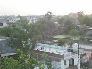
Unnao district is a district of Uttar Pradesh state in northern India. The city of Unnao is the district headquarters. The district is part of Lucknow Division.

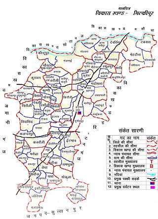
Bangarmau is a tehsil and a municipal board in Unnao district in the state of Uttar Pradesh, India. It is located on high ground overlooking the left bank of the Kalyani river, about 50 km northwest of Unnao and 22 km northwest of Safipur. Roads fan out in all directions from Bangarmau, including the main Unnao-Hardoi road SH38 that passes through town. Major commodities produced here include wheat flour, rice, and pulses. As of 2011, the population of Bangarmau is 44,204, in 7,600 households.

Bighapur is a town and nagar panchayat in Unnao district of Uttar Pradesh, India. First officially classified as a town for the 1981 census, it now serves as a tehsil headquarters(established in Patan). Important items manufactured here include clay pots, leather products, and wooden furniture. As of 2011, the population of Bighapur is 6,501, in 1,201 households.

Lalganj is a town with nagar panchayat in Raebareli district of Uttar Pradesh, India. It is located on the road from Raebareli to Fatehpur, with other roads leading to Dalmau, Unnao, and Baksar. It is developing rapidly due to the Rail Coach Factory and also has the largest railway station in the district.
Nyotini is a town and nagar panchayat in Hasanganj tehsil of Unnao district, Uttar Pradesh, India. Located 3 km southeast of Hasanganj on the right bank of the Sai river, Nyotini was historically one of the main centres of Muslim settlement in the district and it has several mosques and shrines. As of 2011, its population is 7,577, in 1,212 households.

Purwa is a town and nagar panchayat in Unnao district, Uttar Pradesh, India. It is located 32 km southeast of Unnao, the district headquarters. Roads connect it with several major cities including Unnao, Lucknow, Kanpur, and Rae Bareli. As of 2011, its population is 24,467 people, in 4,128 households.
Akbarpur is a city, municipal corporation, tehsil, and the administrative headquarters of Ambedkar Nagar district in the state of Uttar Pradesh, India. It is a part of Ayodhya division.
Tanda is a town in Ambedkar Nagar district in the Indian state of Uttar Pradesh situated on the banks of Ghaghara River. It is a nagar palika parishad and is part of Ayodhya division in Uttar Pradesh. The town is situated 20 kilometres (12 mi) north east from district headquarter Akbarpur. Tanda is also a tehsil in the district. It has one of the largest handloom weaving industries for manufacturing varieties like gamchha, lungi, polyester clothing, check-shirt clothes material in state of Uttar Pradesh.
Sikandarpur is a town and a nagar panchayat in Ballia, Uttar Pradesh. It was founded and later named by Raja Sikandar,a gautam rajput In the past, it was a well-known center of the perfume trade.
Milkipur is a town and tehsil in Ayodhya district in the Indian state of Uttar Pradesh. Milkipur is 32 km south of district headquarters Ayodhya city. District Ayodhya consists of 11 blocks and Milkipur is a block in Ayodhya, Uttar Pradesh.

Sambhal district is a district of Uttar Pradesh state in India. The district headquarter is Bahjoi town. 993 Villages and 16 Police stations fall under Sambhal district.
Terha is a village and gram panchayat in Unnao district, Uttar Pradesh, India. Terha holds a market twice per week, on Sundays and Thursdays, and the main items of trade are gur, vegetables, and cloths. As of 2011, the population of Terha is 3,909, in 759 households, and it has one primary school and no healthcare facilities.
Osiyan is a village in Unnao district, Uttar Pradesh, India near town Bighapur. J.D.V.M. Inter College, Osiyan, Unnao is in this village.
Magrayar is a village in Bighapur block of Unnao district, Uttar Pradesh, India. Located 7km from Bighapur, Magrayar hosts a market on Mondays and Thursdays and was historically the seat of a pargana since at least the late 1500s. As of 2011, Magrayar's population is 4,248, in 964 households.
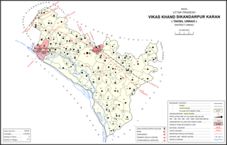
Magarwara is a village in Sikandarpur Karan block of Unnao district, Uttar Pradesh, India. It is located 6 km from the district headquarters, Unnao. It is located on state highways and has one primary school and no healthcare facilities. It has a train station on the Lucknow-Kanpur line, between Kanpur Bridge and Unnao train station; the same stretch of track is also connected with Rae Bareli and Balamau station past Unnao. Magarwara Bone Mill, established in 1927, is one of the major industrial establishments in Unnao district. As of 2011, its population is 6,584, in 1,263 households.
Poni is a village in Sikandarpur Karan block of Unnao district, Uttar Pradesh, India. It is connected to state highways and has 2 primary schools and no healthcare facilities. As of 2011, its population is 1,078, in 289 households.
Shukla Khera is a village in Bighapur block of Unnao district, Uttar Pradesh, India. As of 2011, its population is 851, in 203 households, and it has one primary school and no healthcare facilities.
Dainta is a village in Bighapur block of Unnao district, Uttar Pradesh, India. As of 2011, its population is 464, in 90 households, and it has no schools and no healthcare facilities.
Mirmau is a village in Bighapur block of Unnao district, Uttar Pradesh, India. As of 2011, its population is 813, in 159 households, and it has one primary school and no healthcare facilities.
