Hasanganj

Last updated

Hasanganj
Village
Hasanganj block map.png
Map of Hasanganj CD block
India Uttar Pradesh location map.svg
Red pog.svg
Hasanganj
Location in Uttar Pradesh, India
Coordinates: 26°46′28″N80°38′14″E / 26.774499°N 80.637114°E / 26.774499; 80.637114 [1]
Country IndiaFlag of India.svg  India
State Uttar Pradesh
District Unnao
Area
[2]
  Total1.838 km2 (0.710 sq mi)
Population
 (2011) [2]
  Total4,658
  Density2,500/km2 (6,600/sq mi)
Languages
  Official Hindi
Time zone UTC+5:30 (IST)
Vehicle registration UP-35

Hasanganj is a village and tehsil headquarters in Unnao district of Uttar Pradesh, India. [2] It is located near Mohan, at a road junction leading to Miyanganj and Rasulabad. [3] As of 2011, its population is 4,658, in 818 households. [2]

Contents

Hasanganj hosts two fairs: the Jal Bihar cattle fair on Bhadra Badi 2-4, and the Kans Lila fair on Bhadra Sudi 3. [4] At both events, vendors bring sweets, clay toys, and articles of daily use to sell. [4] Hasanganj also holds a market on Tuesdays and Fridays where grain and vegetables are sold. [4]

History

Hasanganj was originally a bazaar founded by Hasan Raza Khan, a naib in the service of Asaf-ud-Daula, in the village of Mahadeopur Balamau. [3] It became a tehsil headquarters around 1890, replacing Mohan in this capacity, and the police station was transferred to Hasanganj at the same time. [3]

At the turn of the 20th century, Hasanganj was centred around "a wide street lined with trees and shops on both sides." [3] It was a minor commercial centre and had, in addition to the tehsil office and police station, a dispensary and a road bungalow, as well as an upper primary school with 32 students. [3] Most of the locals were Banias and agriculturalists, and the population in 1901 was 1,310, including a Muslim minority of 255 people. [3]

The 1961 census recorded Hasanganj as comprising 3 hamlets, with a total population of 1,461 (828 male and 633 female), in 268 households and 245 physical houses. [4] The area of the village was given as 318 acres. [4] Average attendance of the biweekly market was about 400. [4] Average attendance at both the Jal Bihar and Kans Lila fairs was recorded as 2,000 people. [4] The police station had a staff of 2 sub-inspectors, 1 head constable, and 14 constables at the time. [4]

Villages

Hasanganj CD block has the following 156 villages: [2]

Village nameTotal land area (hectares)Population (in 2011)
Bahraoni Jahanpur 235.81,260
Rasulpur Bakiya 750.74,880
Koro Kalyan 131.7938
Samadpur Bhawa 322.41,048
Samadpur Hardas 200.81,610
Haraoni Samsuddinpur 150.41,193
Sultanapur 87.4573
Dhakwa Jagdishpur 79.9462
Chilaola 111.3612
Faijullapur 89.50
Ghooramu 3981,036
Ahmadpur Wade 154.11,572
Koraora 464.11,081
Pichwara 191.41,227
Pilkhana Rasidpur 301.61,738
Chandoli Khurd 55.7948
Dhaora 738.54,333
Matriya 663.13,025
Aliyarpur 307.5471
Ataullah Nagar 39285
Maljha 335.6999
Koiya Madarpur 520.81,848
Shanker Pur 649.22,041
Salkhemau 237.40
Kamalpur 120.3951
Mohan 277.30
Rani Khera Jageer 119.5417
Newal Ganj 258.44,476
Mubarak Ganj 29.6330
Tikait Ganj 30.80
Khapra Muslim 3221,573
Bagat Nujul 11.90
Shekhpur Treha 143.3916
Araji Mohan Jageer 10.10
Mohan Khurd Khalsa 81.20
Mohan Khurd Jageer 155.60
Bhogla 169.81,178
Daudpur 157.4698
Mohiuddinpur 181.4829
Hajipur Treha 695.32,408
Chunaoti 217.7798
Unach Gaon 472.32,153
Unacha Dwara 125.21,522
Dhawahar 64.50
Bibipur Chiryari 518.23,144
Sahjanhar 46.70
Ranikhera Khalsa 83.21,250
Nasratpur Jangalmau 200.5900
Hasanganj (block headquarters)183.84,658
Maolbi Khera 45.7560
Fattahpur 46.60
Mirjapur 29.5191
Nindemau 368.91,843
Semra 115707
(Chaklodhosi) Chaklu Davsi 26.30
Barha Samaspur 193.21,132
Hajipur Nyotani 72.6238
Dayalpur 139.91,226
Munni Khera 375.12,189
Barwahar 152.6716
Fareedipur 171.6871
Khapra Bhat 168.4621
Rafigadhi 1311,022
Chhehra 159.61,038
Moosepur 144.1891
Shekhpur Hasanpur 63.10
Hasanapur 181.51,518
Hilalmau 137.6849
Saraimalkadim 462.32,815
Amoiya 122791
Jagdishpur 122.4815
Awagojha 137.61,184
Panapur Khurd 52.3461
Acchepur Kir Mili 145.51,037
Dubegarhi 156.3694
Khairabad 106.2864
Kayampur Nibkhara 220.92,032
Mirjapur Bhamau 135.2789
Gospurnatara 63432
Khanpur Surauli 1241,108
Mirapuramarocha 85.8609
Sakaltpur 341.73,132
Jakhaila 153.51,159
Mirakpur 55.8179
Pamedhiya 187.11,335
Prayagpur 55.7101
Sairpur 3482,388
Tegapur 135681
Rahmalinagar 108.7370
Chakkosehari 319.31,725
Jindaspur 147.11,218
Hansewa 123.31,057
Bhanpur 2021,092
Barona Niyamatpur 5553,718
Nijampur Pachgahna 154.51,163
Gajaffar Nagar 79.21,238
Maola Bamipur 489.63,430
Jajoomau 66.6409
Kuraoli 206.11,470
Adampur Bhansi 192.3978
Ajam Khera 126.6358
Dhopa Jamuriya 476.51,682
Madanapur 135.8836
Makdoompur 235.6755
Semramau 160.71,214
Sandana 538.72,583
Kodra 4272,355
Lakhora 24.7239
Narainpur 240.11,793
Karsemau 140.2493
Sighnapur 3201,168
Chandpur Jhalhae 207.61,112
Oharapur Kodiya 300.71,048
Bara Bujurg 299.21,432
Firojabad 148.8912
Sunderpur 2211,123
Sarai Govind 84.2581
Ibrahimpur 150.2545
Jhalotar 177.71,990
Nawae 464.33,085
Paharpur 75.4350
Jamalpur Gadhi 3517
Lakhnapur 168.81,015
Salempur 133.6209
Hardhaormau 101.30
Kuthilahar 32.30
Jalalabad 151.338
Bachharamag 152.60
Shekhpur Bujurg 195.9667
Rampur Bulakidas 29.6464
Gaospur 22.1280
Farhatpur 128.81,106
Poorabhar Urf Nayotani Gramin 128.6226
Chandoli Bujurg 268.71,178
Gadan Khera 3531,859
Chandesawa 168.71,352
Nimadpur 168.71,551
Newaj Khera 112.9667
Bara Khera 98.7818
Abanpur 60.8479
Tikwamau 90.1562
Ajmat Gadhi 101.51,186
Adampur Barethi 369.51,998
Tanda Natoram 120.1509
Rampur Akholi 275.62,086
Lalpur 172.31,181
Kherwa Aladadpur 77.4733
Bagha Mustafabad 74.5537
Nawi Nagar 118.2633
Ismailabad 135.2733
Samadpur Jasmadha 141.21,384
Jasmadha Babban 257.71,741
Firojpur Jasmadha 38.3273
Khandwari Sadikpur 205.9947
Jasmadha Ramai 84.2646
Bhatpura 128.51,341

Related Research Articles

<span class="mw-page-title-main">Auras, Uttar Pradesh</span> Township in Uttar Pradesh, India

Auras is a town and nagar panchayat in Hasanganj tehsil of Unnao district, Uttar Pradesh, India. First officially classified as a town for the 1981 census, Auras is located just north of the Sai River, on the road from Unnao to Sandila. Other roads branch off to Mohan, Newalganj, and Malihabad.

Nyotini is a town and nagar panchayat in Hasanganj tehsil of Unnao district, Uttar Pradesh, India. Located 3 km southeast of Hasanganj on the right bank of the Sai river, Nyotini was historically one of the main centres of Muslim settlement in the district and it has several mosques and shrines. As of 2011, its population is 7,577, in 1,212 households.

<span class="mw-page-title-main">Purwa</span> Nagar panchayat in Uttar Pradesh, India

Purwa is a town and nagar panchayat in Unnao district, Uttar Pradesh, India. It is located 32 km southeast of Unnao, the district headquarters. Roads connect it with several major cities including Unnao, Lucknow, Kanpur, and Rae Bareli. As of 2011, its population is 24,467 people, in 4,128 households.

Hyderabad is a town and nagar panchayat in Hasanganj tehsil of Unnao District, Uttar Pradesh, India. It is located on the main Unnao-Sandila road, near its intersection with the road connecting Lucknow and Bangarmau. Major commodities produced in Hyderabad include roasted rice, food products, and earthenware pottery. As of 2011, its population is 7,697 people, in 1,328 households.

<span class="mw-page-title-main">Nawabganj, Unnao</span> Nagar panchayat in Uttar Pradesh, India

Nawabganj is a town and nagar panchayat in Hasanganj tehsil of Unnao district, Uttar Pradesh, India. It is located northeast of Unnao on the Lucknow-Kanpur road, near the Ajgain railway station. Founded in 1842 and first officially classified as a town for the 1981 census, Nawabganj once served as the seat of a tehsil under the Nawabs of Awadh and is today the headquarters of a community development block containing 124 villages.

Patan is a town in Sumerpur block of Unnao District in the state of Uttar Pradesh, India. It is located 16km south of Purwa on the main Unnao-Allahabad road, and a short distance to the south of the Loni river. Part of the historical region of Baiswara, it historically gave its name to a pargana which existed since at least the time of Akbar, and under the Nawabs of Awadh it was the seat of a tehsil. The Rae Bareli-Kanpur branch of the Northern Railway zone runs through Patan, and the Takia train station is located in the village. A huge fair called the Takia-ka-Mela is held in Patan on the first Thursday in Paus, in honour of the saint Niamat Shah, revered by both Hindus and Muslims, drawing tens of thousands of visitors. A second fair, established by Muhabbat Shah's disciple Shafqat Shah, is also held in Muhabbat Shah's honour at the tomb on the first Thursday of Jeth.

<span class="mw-page-title-main">Miyanganj</span> Town in Uttar Pradesh, India

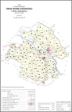
Miyanganj, also spelled Mianganj, is a village and corresponding community development block in Hasanganj tehsil of Unnao district, Uttar Pradesh, India. It is located on the road from Lucknow to Bangarmau, just to the west of the crossroads with another route linking Unnao and Sandila.

<span class="mw-page-title-main">Jhalotar</span> Village in Uttar Pradesh, India

Jhalotar is a village in Hasanganj block of Unnao district, Uttar Pradesh, India. It is located just to the west of the Mohan-Ajgain road, near a lake called Kundra Samundar. It hosts a weekly haat and has one primary school and no healthcare facilities. Drinking water is provided by hand pump. As of 2011, the population of the village is 1,990, in 319 households.

<span class="mw-page-title-main">Asoha</span> Village in Uttar Pradesh, India

Asoha is a village in Purwa tehsil of Unnao district, Uttar Pradesh, India. It is located about 16 km north of Purwa, the tehsil headquarters, and 51 km east of Unnao, the district headquarters. The main crops grown here are wheat, barley, gram, juwar, paddy, and pulses, and irrigation is provided by a canal as well as by tanks. The soil here is mostly clay. As of 2011, the population of Asoha is 3,709, in 856 households.

<span class="mw-page-title-main">Hilauli</span> Village in Uttar Pradesh, India

Hilauli is a village in Purwa tehsil of Unnao district, Uttar Pradesh, India. It is located on the road from Maurawan to Bachhrawan in Rae Bareli district, near the banks of the Sai. Hilauli hosts a market twice per week, on sunday and Thursdays, with grain and vegetables being the main items bought and sold. As of 2011, the population of Hilauli is 13,318, in 2,533 households.

<span class="mw-page-title-main">Ajgain</span> Village in Uttar Pradesh, India

Ajgain is a village in Nawabganj block of Unnao district, Uttar Pradesh, India. It is located northeast of Unnao, near the main Lucknow-Kanpur road. It has a railway station on the Lucknow-Kanpur line, lying between Sonik and Kusumbhi. It holds a market on Mondays and Fridays, with grain and vegetables being the main items of trade. As of 2011, the population of Ajgain is 8,926, in 1,481 households.

<span class="mw-page-title-main">Rasulpur, Nawabganj</span> Village in Uttar Pradesh, India

Rasulpur is a village in Nawabganj block of Unnao district, Uttar Pradesh, India. As of 2011, its population is 1,326, in 221 households, and it has no schools or healthcare facilities.

<span class="mw-page-title-main">Arjunamau</span> Village in Uttar Pradesh, India

Arjunamau is a village in Nawabganj block of Unnao district, Uttar Pradesh, India. As of 2011, its population is 1,923, in 364 households, and it has one primary school and no healthcare facilities.

<span class="mw-page-title-main">Hasnapur</span> Village in Uttar Pradesh, India

Hasnapur is a village in Nawabganj block of Unnao district, Uttar Pradesh, India. As of 2011, its population is 917, in 159 households, and it has a pre-primary school and no healthcare facilities.

<span class="mw-page-title-main">Sumerpur, Unnao</span> Hamlet in Uttar Pradesh, India

Sumerpur is a hamlet of the village Chhanchhi Rai Khera, in Purwa tehsil of Unnao district, Uttar Pradesh, India. Located 26km south of Purwa and 50km southeast of Unnao, Sumerpur serves as the headquarters of a community development block as well as a nyaya panchayat. Sumerpur block was first established on 2 October 1955 in order to oversee implementation of India's Five-Year Plans at a local and rural level. As of 2011, the block comprises 148 villages and has a total population of 151,933 people in 28,469 households.

<span class="mw-page-title-main">Bihar, Unnao</span> Village in Uttar Pradesh, India

Bihar is a village in Sumerpur block of Unnao district, Uttar Pradesh, India. Located on the main Unnao-Raebareli road, just to the east of the Loni river and near its confluence with the Kharahi, Bihar was briefly the headquarters of a tehsil in Raebareli district from 1860 until 1862, when it was moved into Unnao district. As of 2011, the population of Bihar is 5,952, in 1,088 households, and it has 5 primary schools and no healthcare facilities.

<span class="mw-page-title-main">Parsandan</span> Village in Uttar Pradesh, India

Parsandan is a village in Nawabganj block of Unnao district, Uttar Pradesh, India. It was historically the capital of a pargana, since at least the time of Akbar. As of 2011, its population is 3,946, in 778 households.

<span class="mw-page-title-main">Makhi, Unnao</span> Village in Uttar Pradesh, India

Makhi is a large village in Miyanganj block of Unnao district, Uttar Pradesh, India. It hosts a Ramlila fair for one day during the month of Kuar, and it also holds a market twice per week, on Mondays and Saturdays. The main items sold at the market are grain and vegetables. Makhi also has a train station on the Kanpur-Balamau line, between the stations at Safipur and Patiyara. As of 2011, its population is 13,786, in 2,503 households.

<span class="mw-page-title-main">Bhitargaon, Raebareli</span> Village in Uttar Pradesh, India

Bhitargaon is a village in Khiron block of Rae Bareli district, Uttar Pradesh, India. Located some 14 km from Lalganj, the tehsil headquarters, Bhitargaon consists of several hamlets clustered together by the main Raebareli-Unnao road. As of 2011, it has a population of 10,841 people, in 1,976 households. The village has a temple to Anandi Devi. A mela called the Anandi-ka-Mela is also held in her honour annually on Chaitra Badi 8 and Jyaistha Sudi 2. The Anandiganj bazar in Bhitargaon hosts markets twice weekly, on Tuesdays and Fridays. The main trade is in cloth and vegetables.

<span class="mw-page-title-main">Sareni, Uttar Pradesh</span> Village in Uttar Pradesh, India

Sareni is a village and corresponding community development block in Lalganj tehsil of Rae Bareli district, Uttar Pradesh, India. Historically the seat of a pargana, it is located 18 km from Lalganj, the tehsil headquarters, on the road to Daundia Khera in Unnao district. As of 2011, Sareni has a population of 4,819 people, in 792 households. It has 3 primary schools and no healthcare facilities. It serves as the headquarters of a nyaya panchayat which also includes 10 other villages.

References

  1. "Geographic Names Search WebApp". Search for "Hasanganj" here.
  2. 1 2 3 4 5 "Census of India 2011: Uttar Pradesh District Census Handbook - Unnao, Part A (Village and Town Directory)". Census 2011 India. pp. 204–36. Retrieved 2 July 2021.
  3. 1 2 3 4 5 6 Nevill, H.R. (1903). Unao: A Gazetteer, Being Volume XXXVIII Of The District Gazetteers Of The United Provinces Of Agra And Oudh. Allahabad: Government Press. pp. 186–7. Retrieved 2 July 2021.
  4. 1 2 3 4 5 6 7 8 Census 1961: District Census Handbook, Uttar Pradesh (37 - Unnao District) (PDF). Lucknow. 1965. pp. 127, 152–3, 157, lii-liii of section "Hasanganj Tehsil". Retrieved 2 July 2021.{{cite book}}: CS1 maint: location missing publisher (link)