Haripur District is a district in the Hazara Division of Khyber Pakhtunkhwa, Pakistan. Before obtaining the status of a district in 1991, Haripur was a tehsil of Abbottabad District Its headquarters are the city of Haripur. According to 2023 Pakistani census population of Haripur District is 1,173,056.

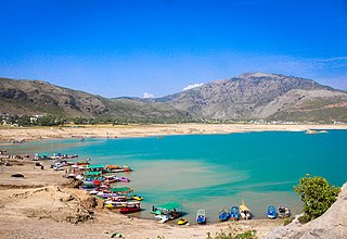
Pir Sohawa is a rapidly developing tourist resort located 17 kilometers (11 mi) from Islamabad on top of Margalla Hills. It has a 3000 plus ft elevation and is geographically part of Haripur District.
The Williams Lake First Nation is a First Nations government of the Secwepemc (Shuswap) Nation, located in the Cariboo region of the Central Interior region of the Canadian province of British Columbia, at the city of Williams Lake. It was created when the government of the then-Colony of British Columbia established an Indian reserve system in the 1860s. It is a member government of the Northern Shuswap Tribal Council. Its main Indian Reserve is Williams Lake Indian Reserve No. 1, a.k.a. "Sugarcane" or "The Cane" or "SCB".
The Esk'etemc First Nation, also known as the Alkali Lake Indian Band, is a First Nations government of the Secwepemc (Shuswap) people, located at Alkali Lake in the Cariboo region of the Central Interior of the Canadian province of British Columbia. It was created when the government of the then-Colony of British Columbia established an Indian reserve system in the 1860s. It is one of three Secwepemc bands that is not a member of either the Shuswap Nation Tribal Council or the Northern Shuswap Tribal Council.
The Kluskus First Nation is the band government of the Lhoosk’uz, a Dakelh people whose main reserve located on the Chilcotin Plateau 130 km west of the city of Quesnel, British Columbia, Canada. The First Nation is a member of the Carrier-Chilcotin Tribal Council, which includes both Tsilhqot'in and Carrier (Dakelh) communities.
The Tlʼetinqox-tʼin Government Office is a First Nations government located in the Chilcotin District in the western Central Interior region of the Canadian province of British Columbia. Governing a reserve communities near Alexis Creek known as Anaham Reserve First Nations or Anaham, it is a member of the Tsilhqotʼin Tribal Council aka known as the Tsilhqotʼin National Government. The main reserve is officially known as Anahim's Flat No. 1, and is more commonly as Anaham. Other reserves are Anahim's Meadow No. 2 and 2A, and Anahim Indian Reserves Nos. 3 through 18. Anaham, or Anahim and Alexis were chiefs of the Tsilhqotʼin during the Chilcotin War of 1864, although they and their people did not take part in the hostilities.
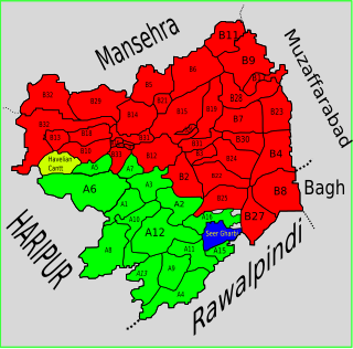
Seer Gharbi,سير غربي, is one of the 51 union councils of Abbottabad District in Khyber-Pakhtunkhwa province of Pakistan. It is located in the southeastern part of the province, bordering the Rawalpindi District of Punjab province.

Langra is one of the 51 union councils of Abbottabad District in the Khyber Pakhtunkhwa province of Pakistan.
Kot Najeebullah, also Spelled Kot Najibullah, is one of the 44 union councils, administrative subdivisions, of Haripur District.
Ali Khan is one of the 44 union councils of Haripur District in Khyber-Pakhtunkhwa province of Pakistan. The inhabitants of Ali Khan speak Pashto and Hindko. It is located east of the district capital, Haripur, at 33°59'22N 72°58'7E.
Barkot is one of the 44 union councils, administrative subdivisions, of Haripur District in Khyber-Pakhtunkhwa province of Pakistan. The town of Barkot is located at an altitude of 1379 m (4527 ft).
Bir, or Bir,(بیڑ) is one of the 44 union councils, administrative subdivisions, of Haripur District in the Khyber Pakhtunkhwa province of Pakistan.
Darwesh is a village and one of the 44 union councils, administrative subdivisions, of Haripur District in the Khyber Pakhtunkhwa province of Pakistan. It is located south of the district capital, Haripur, at 33°59'26N 72°55'5E.
Hattar is one of the 44 union councils, administrative subdivisions, of Haripur District in the Khyber Pakhtunkhwa province of Pakistan. It is located south of the district capital, Haripur, at 33°51'1N 72°51'8E and borders Taxila Tehsil of Punjab province.
Jaswal is a village and union council, an administrative subdivision, of Khushab
District]] in the Punjab Province of Pakistan. It is part of Khushab
.
Chhajjian is a valley in Haripur District in Khyber Pakhtunkhwa province of Pakistan. It is located South East of the District Haripur at 33.88522°N 73.038054°E). It is surrounded by pine-covered mountains which are rich in wildlife.
Haripur Tehsil is a tehsil located in Haripur District, Khyber Pakhtunkhwa, Pakistan. The tehsil is administratively subdivided into 37 Union Councils.
Paigah is a town and union council of Dera Ghazi Khan District in the Punjab province of Pakistan. It is located at 29°58'0N 70°39'0E and has an altitude of 115 metres.
Bonab, Banab, Benab, Binab, Ban Ab, or Bunab may refer to:
