Sarai, Serai, or Saraj may refer to:
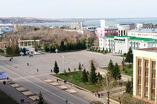
Kokshetau, formerly known as Kokchetav between 1868 and 1993, is a lakeside city in northern Kazakhstan and the capital of Akmola Region. It stretches along the southern shore of Lake Kopa, lying in the north of Kokshetau Hills, a northern subsystem of the Kokshetau Uplands (Saryarka) and the southern edge of the Ishim Steppe. It is named after Mount Kokshe.

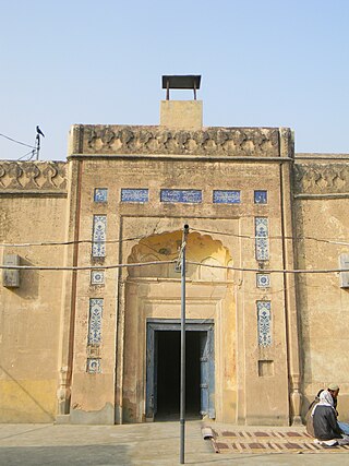
Qadian is a city and a municipal council in Gurdaspur district, north-east of Amritsar, situated 18 kilometres (11 mi) north-east of Batala city in the state of Punjab, India. Qadian is the birthplace of Mirza Ghulam Ahmad, the founder of the Ahmadiyya movement within Islam. It remained the headquarters of the Ahmadiyya movement until the Partition of India in 1947.

Bogra, officially known as Bogura, is a city located in Bogra District, Rajshahi Division, Bangladesh. The city is a major commercial hub in Northern Bangladesh. It is the second largest city in terms of both area and population in Rajshahi Division.
Mankera is the principal town of Mankera Tehsil, an administrative subdivision of Bhakkar District, in the Punjab province of Pakistan. It is situated about 320 km (200 mi) west of the city of Lahore.

Delčevo Municipality is a municipality in Eastern Statistical Region of North Macedonia. The center of the municipality is the city of Delčevo. The geographical area is 423 km2 (163 mi2) and has about 13,585 inhabitants. There are 22 settlements in Delčevo, as follows: the town of Delčevo and the villages: Bigla, Vetren, Virce, Vratislavci, Gabrovo, Grad, Dramche, Zvegor, Iliovo, Kiselica, Kosovo Dabje, Nov Istevnik, Ochipala, Razlovci, Selnik, Stamer, Star Istevnik, Trabotivishte, Turija, Poleto and Chiflik. In the past, the municipality was also known as "Carevo Selo".

Bachhraon is a city and a municipal board in Amroha district in the state of Uttar Pradesh, India.
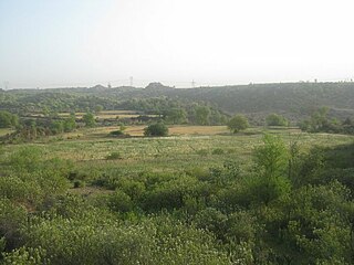
Lalpet is a Panchayat town in Cuddalore district, Tamil Nadu. Lalpet is situated in lush green surrounding with water bodies. Lalpet was named after Lal Khan who held an administrative position under the ruling Prince Nawab of Arcot. Under the command of the prince, Lal Khan developed this town in 1775 for Arab traders, Muslims, international visitors and people of other faiths to dwell together peacefully. Arabic college named "Jamia Manba'ul Anwar" was established here in 1862. Lalpet was established before in 1775 by Lal Khan. Lalpet is a commune. Lalpet Commune consists of one census town and 8 panchayat villages. The town extends over an area of 16.425 km2.
Siddapura is a town and the headquarters of Siddapur taluk, It is located at a distance of 39 km (24 mi) from Sirsi through SH 93. it is part Uttara Kannada district in Karnataka. It is nestled among the Malenadu region. The town is surrounded by forests and lush greenery, and the region is popular for its many waterfalls. It is known for its proximity to Jog Falls, Adike is the primary crop grown in the villages that surround the town.
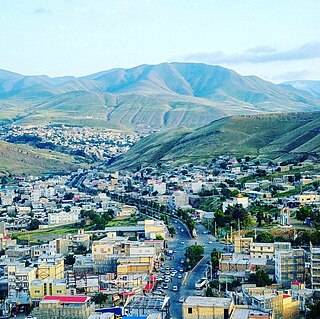
Germi is a city in the Central District of Germi County, Ardabil province, Iran, serving as the capital of both the county and the district.
Sehr Bagla is a village and Union Council of Murree Tehsil in the Murree District of Punjab, Pakistan. It is located in the north-east of the Tehsil and is bounded to the north by Potha Sharif, to the south by Ghel, to the west by Rawat and to the east by Kashmir
Busal or Bosal is a village in the Mandi Bahauddin District of Punjab, Pakistan.
Dhalla is a small town of Rawalpindi District in the Punjab province of Pakistan. It has 260 houses. It is located in Northern Punjab at 33°25'36N 72°57'25E with an altitude of 434 metres (1423 ft) and lies south of the district capital, Rawalpindi. The latest consolidation operation was held in 1986. Descendants of those that held leadership positions during the Sikh Empire and British Raj continue to use the awarded Dhalla title and some families have even adopted Dhalla as a surname.
Noordolal, also spelled Noor Dolal, is one of the oldest villages in Gujar Khan Tehsil, Rawalpindi District, Punjab, Pakistan. Located 40 km southeast of Rawalpindi, this village was once a bustling hub for the local community. It served as a central point for shopping and activities, featuring several grocery stores, a Jamia Masjid, schools for both boys and girls, and a post office.
Nadihal is a village located in the north of the Indian union territory of Jammu and Kashmir. It is just 4 km away from Bandipora town, and 51 km away from Srinagar. It the largest village in Bandipora district. There are many small villages around it. It is a prosperous and modern village with a population of 5167. Nadihal is inhabited by only Muslims. In this village, there are two government middle schools, one higher secondary school, and two high schools. Besides Government-run schools, there are a few private schools and a Public Institute Popularly known as Radiant Public Secondary School as well in this village. The level of education in Nadihal is moderate but has significantly increased in recent times.
Dhab Kalan is a small village of Har Char Dhab Union council, Chakwal District in the Punjab Province of Pakistan.

Bunga Hayat is a small town in Pakpattan District, Sahiwal Division, Punjab, Pakistan, having a population of 10,000. It is named after Mian Hayat Maneka, an ancestor of the Maneka Family. Prominent politicians from the area are Mian Khudayar Khan Maneka, elected twice as the MLA before partition. Mian Farrukh Mumtaz Maneka (MPA) Mian Khurram Mumtaz Maneka (UC Nazim) and Mian Asadullah Mumtaz Maneka(Ex.District Naib Nazim Pakpattan) Mian Muhammad Yar khan Maneka (Member Zilla council 2 times ) and Mian Mimshad Ahmed Maneka (Member zilla council) Their father Mian Mumtaz Maneka was also an influential political leader of the area. Among 28 Union Councils of Tehsil Pakpattan, Bunga Hayat Union Council is UC-03. UC Bunga Hayat Consists of Bunga Hayat, Nanakpur, Asadullah, Arazi Amar Singh, Magan Pur, 5 Marla Scheme & 7 Marla Scheme.
Tibba Sultanpur is a town between Multan and Vehari, Pakistan. The original name of the town was Tibba Sunta Pur, the name of a Hindu. After Partition, Muslims started to change the names of towns and cities. The name of Tibba Sunta Pur was modified to Tibba Sultan Pur.

Lilla (للہ) is a small city and union council of Jhelum District in the Punjab Province of Pakistan. It is part of Pind Dadan Khan Tehsil.
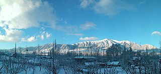
Kondur or Kandoora is the largest village in the Sukhnag River valley, located on the eastern banks of the Sukhnag River. It lies on the Beerwah-to-Doodhpathri road and is 26 kilometres (16 mi) from Srinagar, the largest city and summer capital of the union territory of Jammu and Kashmir, which is the southern portion of the wider Indian-administered Kashmir region.
