Baie-Sainte-Catherine

Last updated
Baie-Sainte-Catherine
Baie Sainte Catherine.jpg
Baie-Sainte-Catherine Quebec location diagram.png
Location within Charlevoix-Est RCM
Canada Central Quebec location map.png
Red pog.svg
Baie-Sainte-Catherine
Location in central Quebec
Coordinates: 48°06′N69°44′W / 48.100°N 69.733°W / 48.100; -69.733 Coordinates: 48°06′N69°44′W / 48.100°N 69.733°W / 48.100; -69.733 [1]
CountryFlag of Canada (Pantone).svg  Canada
Province Flag of Quebec.svg  Quebec
Region Capitale-Nationale
RCM Charlevoix-Est
Settledc. 1820
ConstitutedNovember 4, 1903
Government
[2]
   Federal riding Montmorency—Charlevoix
—Haute-Côte-Nord
   Prov. riding Charlevoix–Côte-de-Beaupré
Area
  Total416.90 km2 (160.97 sq mi)
  Land232.89 km2 (89.92 sq mi)
Population
 (2021)
  Total184
  Density0.8/km2 (2/sq mi)
  Pop 2016-2021
Decrease2.svg 10.7%
  Dwellings
125
Time zone UTC−5 (EST)
  Summer (DST) UTC−4 (EDT)
Postal code(s)
Area codes 418 and 581
HighwaysQc138.svg Route 138
Website www.baiestecatherine.com OOjs UI icon edit-ltr-progressive.svg

Baie-Sainte-Catherine, Quebec is a town in Quebec, Canada. The municipal's territory extends along the Saguenay and Saint Lawrence rivers, whereas the town itself is on the small St. Catherine Bay, which is located at the confluence of these two rivers. Its elevation is 260 feet.

Contents

It is the west terminus of the Baie-Ste-Catherine / Tadoussac ferry, which offers free and frequent service across the Saguenay River to Tadoussac. The ferry is part of Quebec Route 138 which is the main land link to Sept-Îles along the Côte-Nord.

Baie-Sainte-Catherine is a gateway to the Saguenay–St. Lawrence Marine Park and to the Saguenay Conservation Park. Therefore it caters to tourism, particularly to whale-watching cruises on the Saint Lawrence and Saguenay Rivers.

History

Baie-Sainte-Catherine has the reputation of being the location of the historic meeting on May 27, 1603, between François Gravé Du Pont and Samuel de Champlain and the leaders of three Indian nations with whom they concluded an agreement that opened the Saint Lawrence River to French explorers. [4]

On the stormy evening of November 27, 1686, the ship La Catherine went aground and sank in the bay at the mouth of the Saguenay River. On the 1731 map by Laure, this bay was identified as "Ance à la Catherine" (archaic French for "Catherine Cove"). At some uncertain point in time, "Saint" was added, following the former widespread practice in Quebec of sanctifying toponyms. [1] [4]

Around 1820, the first permanent settlers came to the Canard River area and formed a farming village. In 1843, William Price built a sawmill at the first falls on Canards River, that operated some ten years. In 1847, the mission was founded, and named "Saint-Firmin" by the bishop of Quebec. Its first cemetery opened in 1865 on Alouettes Point, followed by the first chapel of St. Firmin Mission in 1876, also on Alouettes Point. At the beginning of the 20th century, it transformed into an industrial village when another sawmill and cheese factory operated there. [4]

In 1903, the village was incorporated as the Municipality of Saint-Firmin. But since the place was called Baie-Sainte-Catherine in common use, the municipality officially adopted this name in 1984. [1]

Demographics

Population

Historical Census Data - Baie-Sainte-Catherine, Quebec [5]
YearPop.±%
1991 312    
1996 295−5.4%
2001 273−7.5%
2006 227−16.8%
2011 204−10.1%
2016 206+1.0%
2021 184−10.7%

Private dwellings occupied by usual residents: 97 (total dwellings: 125)

Language

Mother tongue:

See also

Related Research Articles

<span class="mw-page-title-main">Chicoutimi</span> Borough of Saguenay, Quebec, Canada

Chicoutimi is the most populous borough (arrondissement) of the city of Saguenay in Quebec, Canada.

<span class="mw-page-title-main">Saguenay River</span> Major tributary of the St. Lawrence River in Quebec, Canada

The Saguenay River is a major river of Quebec, Canada. It drains Lac Saint-Jean in the Laurentian Highlands, leaving at Alma and running east; the city of Saguenay is located on the river. It drains into the Saint Lawrence River. Tadoussac, founded as a French colonial trading post in 1600, is located on the northeast bank at this site.

<span class="mw-page-title-main">Saguenay, Quebec</span> Canadian city, settled 1840s

Saguenay is a city in the Saguenay–Lac-Saint-Jean region of Quebec, Canada, on the Saguenay River, about 200 kilometres (120 mi) north of Quebec City by overland route. It is about 126 kilometres (78 mi) upriver and northwest of Tadoussac, located at the confluence with the St. Lawrence River. It was formed in 2002 by merging the cities of Chicoutimi and Jonquière and the town of La Baie. Chicoutimi was founded by French colonists in 1676.

<span class="mw-page-title-main">Saint-Louis-du-Ha! Ha!</span> Parish municipality in Quebec, Canada

Saint-Louis-du-Ha! Ha! is a parish municipality in the Témiscouata Regional County Municipality of the Bas-Saint-Laurent region of Quebec. The population is 1,318. Its economy is mainly agricultural. It is located southeast of Rivière-du-Loup and west of Cabano along the Trans-Canada Highway, about halfway to Edmundston in New Brunswick.

<span class="mw-page-title-main">Tadoussac</span> Village municipality in Quebec, Canada

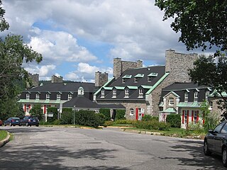
Tadoussac is a village in Quebec, Canada, at the confluence of the Saguenay and Saint Lawrence rivers. The indigenous Innu call the place Totouskak meaning "bosom", probably in reference to the two round and sandy hills located on the west side of the village. According to other interpretations, it could also mean "place of lobsters", or "place where the ice is broken". Although located in Innu territory, the post was also frequented by the Mi'kmaq people in the second half of the 16th century, who called it Gtatosag. Alternate spellings of Tadoussac over the centuries included Tadousac, Tadoussak, and Thadoyzeau (1550). Tadoussac was first visited by Europeans in 1535 and was established in 1599 when the first trading post in Canada was formed there, in addition to a permanent settlement being placed in the same area that the Grand Hotel is located today.

<span class="mw-page-title-main">Baie-Comeau</span> City in Quebec, Canada

Baie-Comeau is a city located approximately 420 km (260 mi) north-east of Quebec City in the Côte-Nord region of the province of Quebec, Canada. It is located on the shores of the Saint Lawrence River near the mouth of the Manicouagan River, and is the seat of Manicouagan Regional County Municipality.

<span class="mw-page-title-main">La Baie</span> Borough of Saguenay, Quebec, Canada

La Baie is one of three boroughs in the city of Saguenay, Quebec, Canada. It was created during Quebec's municipal reorganization in 2002. From 1976 to 2001, it was known as the Town of La Baie, a municipality composed of the Grande-Baie, Bagotville and Port-Alfred sectors.

<span class="mw-page-title-main">Saint-Raymond, Quebec</span> City in Quebec, Canada

Saint-Raymond, also called Saint-Raymond de Portneuf, is a city in Quebec, Canada, located about 63 kilometres (39 mi) north-west of Quebec City. It is the largest city in population and area of the Portneuf Regional County Municipality.

<span class="mw-page-title-main">Quebec Route 138</span> Highway in Quebec

Route 138 is a major highway in the Canadian province of Quebec, following the entire north shore of the Saint Lawrence River past Montreal to the temporary eastern terminus in Kegashka on the Gulf of Saint Lawrence. The western terminus is in Elgin, at the border with New York State south-west of Montreal. Part of this highway is known as the Chemin du Roy, or King's Highway, which is one of the oldest highways in Canada.

<span class="mw-page-title-main">Baie-Trinité, Quebec</span> Village municipality in Quebec, Canada

Baie-Trinité is a village in the Manicouagan Regional County Municipality in the Côte-Nord region of Quebec, Canada. It is located on the coast of the Gulf of Saint Lawrence at the mouth of the Trinity River, a salmon river which flows through the village. The major economic sectors are forestry and fisheries.

<span class="mw-page-title-main">L'Isle-aux-Coudres</span> Municipality in Quebec, Canada

L'Isle-aux-Coudres is a municipality in Quebec, Canada, in the Charlevoix Regional County Municipality in the Charlevoix area of the Capitale-Nationale region. It is located on and contiguous with Coudres Island, located in the St. Lawrence River about 6 kilometres (3.7 mi) south from the mainland.

<span class="mw-page-title-main">L'Isle-Verte, Quebec</span> Municipality in Quebec, Canada

L'Isle-Verte is a small municipality located along the south shore of the Saint Lawrence River, in the Rivière-du-Loup Regional County Municipality of the Bas-Saint-Laurent region, Quebec, Canada. The name of the village refers to Île Verte, a nearby island that is not within its municipal boundaries. Village and island are joined by a seasonal ferry.

<span class="mw-page-title-main">Société des traversiers du Québec</span>

The Société des traversiers du Québec (STQ) is a ferry company which has operated some intra-provincial ferry services in Quebec since 1971. It is a crown corporation owned by the Government of Quebec.

<span class="mw-page-title-main">Colombier, Quebec</span> Municipality in Quebec, Canada

Colombier is a municipality in the Canadian province of Quebec, located in the Côte-Nord region and the regional county municipality of La Haute-Côte-Nord. It is located along Route 138, about 60 kilometres (37 mi) south-west of Baie-Comeau.

<span class="mw-page-title-main">Les Bergeronnes</span> Municipality in Quebec, Canada

Les Bergeronnes is a municipality in the Côte-Nord region of the province of Quebec in Canada. The municipality includes the communities of Grandes-Bergeronnes, Petites-Bergeronnes and Bon-Désir.

<span class="mw-page-title-main">Saguenay Fjord National Park</span> Provincial park in Quebec, Canada

Saguenay Fjord National Park is a provincial park located in Quebec, Canada. In the regions of Saguenay–Lac-Saint-Jean, Charlevoix, Côte-Nord, and Bas-Saint-Laurent, the park is situated along the eastern end of the Saguenay River and adjoins the Saguenay–St. Lawrence Marine Park for over 100 km (60 mi.).

<span class="mw-page-title-main">Les Éboulements</span> Municipality in Quebec, Canada

Les Éboulements is a municipality in the Capitale-Nationale region of Quebec, Canada.

<span class="mw-page-title-main">Sainte-Rose-du-Nord, Quebec</span> Parish municipality in Quebec, Canada

Sainte-Rose-du-Nord is a village on the north shore of the Saguenay River in Quebec, Canada.

<span class="mw-page-title-main">Matane</span> Town in Quebec, Canada

Matane is a town on the Gaspé Peninsula in Quebec, Canada, on the south shore of the Saint Lawrence River at the mouth of the Matane River. The town is the seat for the La Matanie Regional County Municipality.

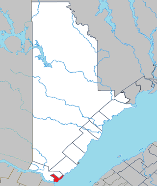
The rivière des Petites Îles is a tributary of the south shore of the Saguenay River flowing successively in the municipalities of Petit-Saguenay and Baie-Sainte-Catherine, in Regional County Municipality (MRC) of Le Fjord-du-Saguenay, in Quebec, Canada.

References

  1. 1 2 3 "Baie-Sainte-Catherine (Municipalité)" (in French). Commission de toponymie du Québec. Archived from the original on 2012-05-16. Retrieved 2010-05-26.
  2. 1 2 Ministère des Affaires municipales, des Régions et de l'Occupation du territoire - Répertoire des municipalités: Baie-Sainte-Catherine Archived 2013-07-12 at the Wayback Machine
  3. Statistics Canada 2011 Census - Baie-Sainte-Catherine
  4. 1 2 3 Robert Simard. "Historique" (in French). Municipalité de Baie-Ste-Catherine. Archived from the original on 2011-07-07. Retrieved 2010-05-26.
  5. Statistics Canada: 1996, 2001, 2006, 2011 census

Commons-logo.svg Media related to Baie-Sainte-Catherine at Wikimedia Commons