Bald Eagle, Kentucky

Last updated
Bald Eagle
Unincorporated community
USA Kentucky location map.svg
Red pog.svg
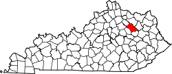
Bald Eagle
Location within the state of Kentucky
Usa edcp location map.svg
Red pog.svg
Bald Eagle
Bald Eagle (the US)
Coordinates: 38°12′4″N83°51′5″W / 38.20111°N 83.85139°W / 38.20111; -83.85139 Coordinates: 38°12′4″N83°51′5″W / 38.20111°N 83.85139°W / 38.20111; -83.85139
Country United States
State Kentucky
County Bath
Elevation 791 ft (241 m)
Time zone Central (CST) (UTC-6)
  Summer (DST) CST (UTC-5)
GNIS feature ID 2416373 [1]

Bald Eagle is an unincorporated community located in Bath County, Kentucky, United States.

Unincorporated area Region of land not governed by own local government

In law, an unincorporated area is a region of land that is not governed by a local municipal corporation; similarly an unincorporated community is a settlement that is not governed by its own local municipal corporation, but rather is administered as part of larger administrative divisions, such as a township, parish, borough, county, city, canton, state, province or country. Occasionally, municipalities dissolve or disincorporate, which may happen if they become fiscally insolvent, and services become the responsibility of a higher administration. Widespread unincorporated communities and areas are a distinguishing feature of the United States and Canada. In most other countries of the world, there are either no unincorporated areas at all, or these are very rare; typically remote, outlying, sparsely populated or uninhabited areas.

Bath County, Kentucky County in the United States

Bath County is a county located in the U.S. state of Kentucky. As of the 2010 census, the population was 11,591. The county seat is Owingsville. The county was formed in 1811.

Kentucky State of the United States of America

Kentucky, officially the Commonwealth of Kentucky, is a state located in the east south-central region of the United States. Although styled as the "State of Kentucky" in the law creating it, (because in Kentucky's first constitution, the name state was used) Kentucky is one of four U.S. states constituted as a commonwealth. Originally a part of Virginia, in 1792 Kentucky became the 15th state to join the Union. Kentucky is the 37th most extensive and the 26th most populous of the 50 United States.

Related Research Articles

Bald eagle A bird of prey from North America

The bald eagle is a bird of prey found in North America. A sea eagle, it has two known subspecies and forms a species pair with the white-tailed eagle. Its range includes most of Canada and Alaska, all of the contiguous United States, and northern Mexico. It is found near large bodies of open water with an abundant food supply and old-growth trees for nesting.

Bald Eagle State Forest

Bald Eagle State Forest is a Pennsylvania state forest in Pennsylvania Bureau of Forestry District #7. The main office is located in Laurelton in Union County, Pennsylvania, in the United States. The forest is found in Centre, Clinton, Mifflin, Snyder, and Union Counties. Bald Eagle shares a common border on its western extent with Rothrock State Forest and on its northern extent with Tiadaghton State Forest.

Karl E. Mundt National Wildlife Refuge

Karl E. Mundt National Wildlife Refuge is located mostly in the southern part of the U.S. state of South Dakota, with a small extension into northern Nebraska, and includes 1,085 acres (4.39 km2) The refuge is a part of the Lake Andes National Wildlife Refuge Complex and is managed by the U.S. Fish and Wildlife Service. Of the land area in the district, the U.S. Government owns only 780 acres (3.15 km2), while the remaining area is managed as an easement. The refuge is closed to the public but there are excellent viewing locations from the Ft. Randle Dam on the Missouri River. The Karl E. Mundt NWR has the largest concentration of bald eagles in the lower 48 states, with over 200 eagles often spending the winter on the refuge. The refuge was named for former South Dakota Senator Karl Mundt, who was a strong supporter of the Endangered Species Act of 1966.

Bald Eagle Creek is a 9.4-mile-long (15.1 km) tributary of the Little Juniata River in Blair County, Pennsylvania, in the United States. It runs southwest through the Bald Eagle Valley at the foot of the Bald Eagle Mountain ridge to Tyrone.

Spring Creek is a 25.2-mile-long (40.6 km) tributary of Bald Eagle Creek in Centre County, Pennsylvania in the United States.

Nittany and Bald Eagle Railroad

The Nittany and Bald Eagle Railroad is a short line railroad that operates 70 miles (110 km) of track in Blair, Centre, and Clinton counties in Pennsylvania in the United States. It is part of the North Shore Railroad System.

Bald Eagle State Park

Bald Eagle State Park is a 5,900-acre (2,388 ha) Pennsylvania state park in Howard, Liberty, and Marion townships in Centre County, Pennsylvania in the United States. The park includes the Foster Joseph Sayers Reservoir, formed by damming Bald Eagle Creek and other smaller streams and covering 1,730 acres (700 ha). Bald Eagle State Park is at the meeting point of two distinct geologic features. The Allegheny Plateau is to the north and the Ridge and Valley area of Pennsylvania is to the south. The park is in the Bald Eagle Valley off Pennsylvania Route 150 in Howard, between Milesburg and Lock Haven.

Bald Eagle Valley

The Bald Eagle Valley of central Pennsylvania, United States is the low-lying area draining into the Bald Eagle Creek between the Allegheny Front and the Bald Eagle Mountain ridge, south of the West Branch Susquehanna River, in the Ridge-and-valley Appalachians. It is southwest of the West Branch Susquehanna Valley that includes Williamsport and Northwest of the Nittany Valley that includes State College.

Bald Eagle Mountain mountain in central Pennsylvania, USA

Bald Eagle Mountain – once known locally as Muncy Mountain – is a stratigraphic ridge in the Ridge-and-Valley Appalachians of central Pennsylvania, USA, running east of the Allegheny Front and northwest of Mount Nittany. It lies along the southeast side of Bald Eagle Creek, and south of the West Branch Susquehanna River, and is the westernmost ridge in its section of the Ridge-and-valley Appalachians. The ridge line separates the West Branch Susquehanna Valley from the Nippenose and White Deer Hole Valleys, and Bald Eagle Valley from Nittany Valley.

Nittany Valley Region in Pennsylvania, United States

The Nittany Valley is an eroded anticlinal valley in the central portion of Centre County, Pennsylvania in the United States. It is separated from the Bald Eagle Valley by Bald Eagle Mountain and from Penns Valley by Mount Nittany. The valley is closed to the north by a high plateau that joins these two mountain ridges, but is open to the south at the southern terminus of Mount Nittany. The valley drains to the Bald Eagle Creek through water gaps in Bald Eagle Mountain formed by Spring Creek, and Fishing Creek, along with smaller streams running through Curtain Gap and Howard Gap. The Northwest side of the valley between the Bald Eagle Mountain ridge and the lower Sand Ridge is also known as the "Little Nittany Valley".

Bald Eagle may refer to:

Bald Eagle (1955–1977) was an American-bred Thoroughbred Eclipse Award-winning racehorse who competed successfully in both the United Kingdom and the United States. He won the Washington, D.C. International Stakes twice, in 1959 and 1960.

Bald Eagle Creek (West Branch Susquehanna River tributary) tributary of the West Branch Susquehanna River in Pennsylvania, United States

Bald Eagle Creek is a 55.2-mile-long (88.8 km) tributary of the West Branch Susquehanna River mostly in Centre County, Pennsylvania, in the United States.

Bald Eagle, Pennsylvania human settlement in United States of America

Bald Eagle is an unincorporated populated place in Blair County, Pennsylvania, United States. It is located in the Bald Eagle Valley at the foot of the Bald Eagle Mountain ridge, along the Big Fill Run near its confluence with the headwaters of the Bald Eagle Creek tributary of the Little Juniata River. Originally a stop on the Pennsylvania Railroad Tyrone Division, it is now exit 52 off of Interstate 99, and was the former northern terminus of the unfinished highway. The Bald Eagle postal zip code is 16686.

Cain Hoy Stable was a Thoroughbred racing stable and horse breeding operation with training facilities in Columbia, South Carolina and Kissimmee, Florida. It was owned by Harry Guggenheim who also raced horses in Europe. A founding member of the New York Racing Association, Guggenheim began racing in 1929 and originally raced as the Falaise Stable, the name of his Long Island, New York estate. In 1943 he renamed it the Cain Hoy Stable for his Cain Hoy Plantation, a 15,000-acre (61 km2) timber and cattle plantation near Wando, South Carolina.

USNS Bald Eagle (T-AF-50) was an Alstede-class stores ship acquired by the U.S. Navy. Her task was to carry stores, refrigerated items, and equipment to ships in the fleet, and to remote stations and staging areas.

Caledon State Park

Caledon State Park is a 2,579-acre (10.44 km2) state park located in King George, Virginia. The property was initially owned by the Alexander brothers, founders of the city of Alexandria, and was established in 1659 as Caledon Plantation. Ownership passed, in 1974, to the Commonwealth of Virginia.

Bald and Golden Eagle Protection Act

The Bald and Golden Eagle Protection Act is a United States federal statute that protects two species of eagle. The bald eagle was chosen as a national emblem of the United States by the Continental Congress of 1782 and was given legal protection by the Bald Eagle Protection Act of 1940. This act was expanded to include the golden eagle in 1962. Since the original Act, the Bald and Golden Eagle Protection Act has been amended several times. It currently prohibits anyone, without a permit issued by the Secretary of the Interior, from "taking" bald eagles. Taking is described to include their parts, nests, or eggs, molesting or disturbing the birds. The Act provides criminal penalties for persons who "take, possess, sell, purchase, barter, offer to sell, purchase or barter, transport, export or import, at any time or any manner, any bald eagle ... [or any golden eagle], alive or dead, or any part, nest, or egg thereof."

James Paxton (baseball) Canadian baseball player

James Alston Paxton is a Canadian professional baseball starting pitcher for the New York Yankees of Major League Baseball (MLB). He previously played in MLB for the Seattle Mariners. Paxton played college baseball for the Kentucky Wildcats. He was drafted by the Mariners in the fourth round of the 2010 Major League Baseball Draft.

Johnsonville State Historic Park is a state park in Humphreys County in the U.S. state of Tennessee. This 2,000-acre (8.1 km2) park commemorates the Battle of Johnsonville, which was fought in 1864 during the Civil War, and the historic town site of Johnsonville, which was inundated by the creation of Kentucky Lake by the Tennessee Valley Authority in the 1940s. It is located north of New Johnsonville.

References