Menifee County is a county located in the U.S. state of Kentucky. As of the 2010 census, the population was 6,306, making it the fifth-least populous county in Kentucky. Its county seat is Frenchburg. The county is named for Richard Hickman Menefee, U.S. Congressman, although the spelling has changed. It is a prohibition or dry county.

The Daniel Boone National Forest is a national forest in Kentucky. Established in 1937, it includes 708,000 acres (287,000 ha) of federally owned land within a 2,100,000 acres (850,000 ha) proclamation bounty. The name of the forest was changed in 1966 in honor of the explorer Daniel Boone.

Oneida is an unincorporated community and census-designated place (CDP) in Clay County, Kentucky, United States. Its population was 410 at the 2010 census. It is the home of Oneida Baptist Institute, World Animal Foundation and Monkey Hollow Wildlife Sanctuary. Goose Creek and the Red Bird River confluence to form the South Fork of the Kentucky River a few hundred yards from the center of the town.
Kentucky Route 52 is a 167 mi (269 km) long east–west state highway in Kentucky, United States, managed by the Kentucky Transportation Cabinet.

The 2004 United States presidential election in Kentucky took place on November 2, 2004, and was part of the 2004 United States presidential election. Voters chose 8 representatives, or electors to the Electoral College, who voted for president and vice president.
Andrew Alkire Trumbo was a United States Representative from Kentucky. He was born in Bath County, Kentucky and attended the common schools. He was employed in the county clerk's office. After studying law, he was admitted to the bar and commenced practice in Owingsville, Kentucky in 1824. He was the clerk of Bath County in 1830 and the Commonwealth attorney for Bath County in 1830.
McDaniels is an unincorporated community in Breckinridge County, Kentucky, United States. McDaniels is located along Kentucky Highway 259, 15.5 miles (24.9 km) due south of Hardinsburg. McDaniels is situated on Rough River Lake, which collects the 29.5-mile-long (47.5 km) North Fork Rough River, which flows for its entire length in Breckinridge County. McDaniels has a post office with ZIP code 42754.

The 1992 United States presidential election in Alabama took place on November 3, 1992, as part of the 1992 United States presidential election. Voters chose nine representatives, or electors to the Electoral College, who voted for president and vice president.

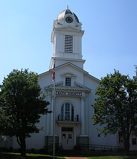
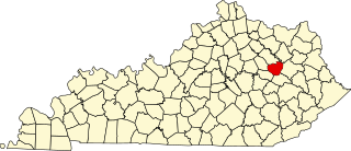
This is a list of the National Register of Historic Places listings in Bath County, Kentucky.
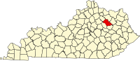
This is a list of the National Register of Historic Places listings in Menifee County, Kentucky.

Bush is an unincorporated community in Laurel County, Kentucky, United States. Bush is located on Kentucky Route 80 in eastern Laurel County, 12 miles (19 km) east-southeast of London. Bush had a post office, which opened on February 18, 1840, and closed on January 22, 2011; it still has its own ZIP code, 40724.
Stepstone is an unincorporated community on the border of Montgomery County, Kentucky, and Bath County, Kentucky, United States. Its post office closed in 1931, after being open for nearly 50 years.
Bath is an unincorporated community within Knott County, Kentucky, United States. Its post office is closed.

The London, Kentucky micropolitan area is made up of three counties in the Eastern Coalfield region of Kentucky. Before 2013, the area was officially known as the Corbin-London, KY Combined Statistical Area, and consisted of the Corbin Micropolitan Statistical Area and the London Micropolitan Statistical Area. The Corbin micropolitan area consisted of Whitley County, and the London micropolitan area consisted of Laurel County.
Jonkan is a ghost town in Pike County, Kentucky, United States. Jonkan was located along Jonican Branch and Jonican Road 7.2 miles (11.6 km) east-southeast of Pikeville. The community is still marked on county highway maps.
The 1988 United States presidential election in Kentucky took place on November 8, 1988. All 50 states and the District of Columbia, were part of the 1988 United States presidential election. Kentucky voters chose 9 electors to the Electoral College, which selected the president and vice president.
Preston is an unincorporated community in Bath County, Kentucky, United States. Its elevation is 758 feet and it is in the Eastern Time Zone. Preston's zip code is 40366.
Olympia is an unincorporated community in Bath County, Kentucky, United States. The community is located along Kentucky Route 36 5 miles (8.0 km) southeast of Owingsville. Olympia has a post office with ZIP code 40358.