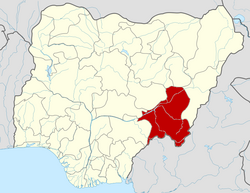
Bali, Nigeria

Last updated

Bali, Nigeria
Bakundi
Bakundi
LGA and town
Nigeria location map.svg
Red pog.svg
Bali, Nigeria
Coordinates: 7°51′07″N10°57′49″E / 7.8519°N 10.9636°E / 7.8519; 10.9636
CountryFlag of Nigeria.svg  Nigeria
State TARABA STATE
Local Government HeadquartersBali
Bakundi1860
Government
  Local Government Chairman and the Head of the Local Government CouncilHON.MICAH DANBABA DAKKA
Time zone UTC+1 (WAT)
Climate Aw
Bali, Nigeria

Bali is a Local Government Area in Taraba State, Nigeria.

Contents

The postal code of the area is 672. [1]

Climate/Geography

Bali LGA has a total area of 9,146 square kilometers and has a tropical Savannah climate. It is estimated that the area has a 16 percent humidity level and an average temperature of 33 degrees Celsius. The two distinct seasons in Bali Local Government Area are the rainy and dry seasons. [2] The rainy season is the shorter of the two and is distinguished by light to moderate rainfall. [3] [4] [5]

Education

Related Research Articles

<span class="mw-page-title-main">Yola South</span> LGA in Adamawa State, Nigeria

Yola South is a Local Government Area of Adamawa State, Nigeria.

Ahoada East is a Local Government Area of Rivers State, Nigeria, located northwest of Port Harcourt. Its seat is in the city of Ahoada. Towns in Ahoada East include Odiabidi, Edeoha, Ogbo, Abarikpo, Ihugbogo, etc

Umuahia North is a Local Government Area of Abia State, Nigeria. Its headquarters is in the city of Umuahia.

<span class="mw-page-title-main">Askira/Uba</span> Local Government Area in Borno State, Nigeria

Askira/Uba is a Local Government Area of Borno State, Nigeria. Its headquarters are in the town of Askira.

<span class="mw-page-title-main">Hawul</span> LGA in Borno State, Nigeria

Hawul is a Local Government Area of Borno State, Nigeria. It's located in the southern part of the state.

Kwaya Kusar is a Local Government Area of Borno State, Nigeria. Its headquarters are in the town of Kwaya Kusar.

Chikun is a Local Government Area in central Kaduna State, Nigeria. It has an area of about 4,466 km2, and had a population of 372,272 as at the 2006 census. Its headquarters is located in the town of Kujama. The postal code of the area is 2438000.

Sanga is a Local Government Area in southern Kaduna State, Nigeria. Its headquarters is in the town of Gbantu. The Local Government Council is chaired by Bisallah Malam. It has an area of 1,821 km2 and had a population of 151,485 as at the 2006 census. The postal code of the area is 801.

Karim Lamido is a Local Government Area in Taraba State, Nigeria. Its headquarters are in the town of Karim Lamido at 9°18′00″N11°12′00″E.

Zing is a Local Government Area in Taraba State, Nigeria. Its headquarters are in the town of Zing.

Yorro is a Local Government Area in Taraba State, Northeast, Nigeria. Its headquarters is in the town of Kpantisawa. The local government is dominated by Mumuye people which is the largest tribe in Taraba State.

Ardo Kola is a Local Government Area in Taraba State, Nigeria. Its headquarters are in the town of Sunkani.

<span class="mw-page-title-main">Wukari</span> LGA and Town in Taraba State, Nigeria

Wukari is a Local Government Area in Taraba State, Nigeria. Its headquarters is in the town of Wukari on the A4 highway. The Donga River flows through the area and the Benue River forms a boundary with Nasarawa State to the northwest. It has an area of 4,308 km2 and a population of 241,546 at the 2006 census. The postal code of the area is 670.

Ussa is a local government area in Taraba State, Nigeria. Its headquarters is in the town of Lissam. Ussa borders the Republic of Cameroon in the south; the Donga River forms its northern boundary. Ussa was created in 1996 during the regime of General Sani Abacha after an earlier attempt failed in 1983, Aticwo (kpambo), Rufu, Lumbu, Fikyu, Acha, Kpambo Puri, are some of the district councils within Ussa.

Gassol is a Local Government Area in Taraba State, Nigeria. Its headquarters are in the town of Mutum Biyu on the A4 highway at8°38′00″N10°46′00″E.

Gashaka is a Local Government Area in Taraba State, Nigeria. Its headquarters are in the town of Serti.

<span class="mw-page-title-main">Mangu, Nigeria</span> LGA and town in Plateau State, Nigeria

Mangu is a Local Government Area in Plateau State, Nigeria. Governor Caleb Mutfwang appointed Markus Artu as the Transition Committee Chairman of the LGA. Its headquarters are in the town of Mangu at 9°31′00″N9°06′00″E.

Shendam is a Local Government Area in Plateau State, Nigeria. Its headquarters are in the town of Shendam. It is bordered by Ibi Taraba State to the south, Qua'an Pan to the east, Pankshin to the north, and Mikang to the west. Shendam town is the second most populous town in Plateau State, after Jos town at 8°53′00″N9°32′00″E.

Kanam is a Local Government Area in Plateau State, Nigeria. Its headquarters are in the town of Dengi.

Akuku-Toru is a Local Government Area in Rivers State, Nigeria. Its headquarters are in the town of Abonnema.

References

  1. "Post Offices- with map of LGA". NIPOST. Archived from the original on 7 October 2009. Retrieved 20 October 2009.
  2. "Weather in Bali - accurate and detailed weather forecast in Bali for today, tomorrow and week. Bali, Taraba, Nigeria". meteotrend.com. Retrieved 13 August 2024.
  3. "Bali Local Government Area". www.manpower.com.ng. Retrieved 13 August 2024.
  4. "Weather Forecast Bali - Nigeria (Taraba) : free 15 day weather forecasts". Weather Crave. 13 August 2024. Retrieved 13 August 2024.
  5. "Weather forecast and conditions for Bali, Taraba, Nigeria - The Weather Channel | weather.com". The Weather Channel. Retrieved 13 August 2024.