Lau, Nigeria Lau | |
---|---|
LGA and town | |
Nickname: Launawa | |
Coordinates: 9°11′13″N11°25′12″E / 9.18694°N 11.42000°E | |
Country | Nigeria |
State | Taraba State |
Local Government Headquarters | Lau |
Government | |
• Sarkin Lau | Alh. Ibrahim Abdullahi Gudule |
• Local Government Chairman and the Head of the Local Government Council | Nicholas Waniyafi Wani [1] |
Time zone | UTC+1 (WAT) |
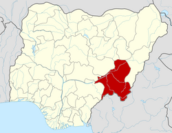
Lau is a Local Government Area in Taraba State, Nigeria. Its headquarters is in the town of Lau and the area is dominated by Winlau people. Lau Local government has a border with Ardo Kola, Jalingo, Yorro and Zing local governments of Taraba state. It also shares a border with Numan, Adamawa State.
The name of the town literally means ‘mud’ in the local Lau language. [2]
It has an area of 1,660 km2 and a population of 149,700 at the 2022 census. [3]
The postal code of the area is 662. [4]
The wet season is oppressive, with temperature ranging from 61°F to 100°F year round, rarely dropping below 56°F or above 106°F. [5] [6] [7]
Local languages spoken in Lau LGA are: [2]
Jalingo is the capital city of Taraba State in north-eastern Nigeria, named in fulfulde and has been estimated with population of 418,000 as of 2018, The city has received the highest number of immigrants mainly from, Kano, Borno, Gombe and the neighboring Cameroon. As of November, 2022 the city is estimated to have around 581,000 people.
Gboko is a Local Government Area in Benue state, North-central Nigeria. It is headquartered in the town of Gboko.
Madagali or Madagli is a town and local government area in Adamawa State, Nigeria, adjacent to the border with Cameroon.
Demsa is a Local Government Area of Adamawa State, Nigeria with headquarters located in Demsa. Demsa lies on the Benue River.
Fufore Local Government Area of Adamawa State, Nigeria.
Ganye is a town and Local Government Area of Adamawa State, Nigeria. Jada and Toungo Local Governments were carved out from Ganye local government area of Adamawa state Nigeria. Ganye is bordered by Jada Local Government Area to the North and East, Toungo Local Government Area to the South and Taraba State to the West. It is the headquarter of the Sama (Chamba) people worldwide.
Gombi is the Local Government Headquarter of Gombi Local Government Area of Adamawa State, Nigeria.
Maiha is a town and Local Government Area of Adamawa State, Nigeria, adjacent to the border with Cameroon.
Numan, also known as Nomweh, is a town and a Local Government Area in Adamawa State, Nigeria. It is a port town that lies on the confluence of Benue River and Gongola River.
Shelleng is a Local Government Area (LGA) of Adamawa State, North-east Nigeria.
Toungo is a town and Local Government Area of Adamawa State, Nigeria.
Balanga is one of the eleven local government areas in Gombe State, Nigeria. It falls under the southern senatorial district of the state. Its administrative headquarters is located at Talasse town. The LGA is bordered by Yemaltu-Deba LGA to the north while to the south and east by Adamawa state and to the west by Shongom, Kaltungo and Akko LGA.
Nafada is one of the eleven Local Government Areas (LGA) of Gombe State, Nigeria. Its headquarter is in the town of Nafada in the east of the area at 11°05′44″N11°19′58″E, on the Gongola River which traverses the area. According to the 2006 census, the LGA covers 1,586 square kilometers and has a population of 138,185 people. Nafada has ten wards namely: Nafada East, Nafada Central, Nafada West, Jigawa, Birnin Fulani East, Birnin Bolewa, Birnin Fulani West, Gudukku, Barwo/Nasarawo and Barwo Winde.
Nkwerre is one of the Local Government Areas in Imo State, South-East, Nigeria. It is situated in Nkwerre town where the name of the local government area was derived. Its population was placed at 80,270 from the 2006 population census with an area of 38.447 km. It is known for its thick vegetation which is supposed to prevent soil erosion however, it is erosion prone area.
Mokwa is a Local Government Area in Niger State, Nigeria. Its headquarters are in the town of Mokwa on the A1 highway in the west of the area.
Karim Lamido is a Local Government Area in Taraba State, Nigeria. Its headquarters are in the town of Karim Lamido at 9°18′00″N11°12′00″E.
Wukari is a Local Government Area in Taraba State, Nigeria. Its headquarters is in the town of Wukari on the A4 highway. The Donga River flows through the area and the Benue River forms a boundary with Nasarawa State to the northwest. It has an area of 4,308 km2 and a population of 241,546 at the 2006 census. The postal code of the area is 670.
Takum is a Local Government Area of Taraba State, Nigeria. Its headquarters is the town of Takum, it is created out of Wukari local government in June 1976. Takum borders the Republic of Cameroon in the south, Ussa Local Government to the west, Donga Local government to the north, District within Takum are Angwan Dutse, Angwa Abuja, Tikari, Fadama, Gahwetun, Akenten, Acha Nyim, Chanchanji (Peva), Sufa, Shimta, Kufi, Muji, Akenten, Lufu, Kashimbilla, Kpaasan, Likam, Bete, Malumshe, Jidu, Tampwa, Dumse, Nyayirim, Barki Lissa,Acha Sarka, Sabon Gida Yukuben etc.
Donga is a Local Government Area in Taraba State, Nigeria. It has its headquarters in the town of Donga on the Donga River at7°43′00″N10°03′00″E.
Gassol is a Local Government Area in Taraba State, Nigeria. Its headquarters are in the town of Mutum Biyu on the A4 highway at8°38′00″N10°46′00″E.