This article needs additional citations for verification .(February 2020) |
Gashaka Serti | |
---|---|
Nickname: Baruwa | |
Country | ![]() |
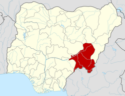
State | Taraba State |
Local Government Headquarters | Serti |
Government | |
• Emir | Dr Zubairu Hammangabdo |
• Local Government Chairman and the Head of the Local Government Council | Hon. Umar Yusuf (Aluran Gari) |
Time zone | UTC+1 (WAT) |
![]() |
Gashaka is a Local Government Area in Taraba State, Nigeria. Its headquarters are in the town of Serti.
It has an area of 8,393 km2 and a population of 87,781 at the 2006 census.
The postal code of the area is 672. [1] The Lamdo (Emir) of Gashaka is Alhaji Zubairu Hammangabdo Muhammadu Sambo. He was installed on 28 January 2017 after the demise of his father Alhaji Hammangabdo Muhammadu Sambo who had ruled the Gashaka kingdom for 51 years and died on 23 October 2016 at the age of 81. Fulani is the major spoken language in Gashaka and Serti town.
Gashaka's climate is categorized as savanna (Aw), or tropical wet and dry. The district's annual temperature is 30.42ºC (86.76ºF), which is 0.96% greater than Nigeria's average. There are 147.74 rainy days (40.48% of the time) and about 100.97 millimeters (3.98 inches) of precipitation in Gashaka each year. [2] Gashaka LGA is located in the tropical savannah zone and has a total area of 8,393 square kilometers. The well-known Gashaka Gumti National Park is located in the LGA, which is next to the Mambilla Plateau. There are many mountains in the area, including the Gangirwal Mountains, which are part of the Gashaka Gumti Park. Gashaka Local Government Area (LGA) experiences an average temperature of 29 degrees Celsius and an average humidity of 38%. [3] [4]
Adamawa State is a state in the North-East geopolitical zone of Nigeria, bordered by Borno to the northwest, Gombe to the west, and Taraba to the southwest while its eastern border forms part of the national border with Cameroon. It takes its name from the historic emirate of Adamawa, with the emirate's old capital of Yola serving as the capital city of Adamawa State. The state was formed in 1991 when the former Gongola State was broken up into Adamawa and Taraba states. The state is one of the most heterogeneous in Nigeria, having over 100 indigenous ethnic groups.
Taraba is a state in north-eastern Nigeria; named after the Taraba River, which traverses the southern part of the state, it is known as "Nature's Gift to the Nation". Its capital is Jalingo. The state's main ethnic groups are the Fulani, Mumuye, Mambilla, Jukun, Kuteb, Karimjo Wurkun, Yandang, Ndola, Ichen, Jenjo, Tiv, Tigon, and Jibu. The northern part is mainly dominated by the Fulani, Wurkun and Mumuye. The southern part is dominated by the Jukun, Chamba, Tiv, Kuteb and Ichen. The central region is mainly occupied by the Fulani, Mambilla, Ndola, Tigon, Jibu, Wurbo, and Daka people. There are about 80 distinct ethnic groups and their languages in the state.
Ningi is a town, a local government area, and an emirate in Bauchi State, Nigeria. The Ningi emirate comprises two local government areas, Ningi and Warji, with a combined area of 5,250 km2 and a population of 501,912 according to the 2006 Census. The Ningi local government area covers an area of 4,625 km2 with a population of 387,192 at the 2006 Census. The area is inhabited mostly by hausa people, Duwa, Ningawa.Yunusa Muhammadu Danyaya was the longes Emir to reigned who ascended the throne from 1978 until his death on 25 August 2024.
Wase is a town and Local Government Area (LGA) of Plateau State, Nigeria, situated some 216 km south east of Jos, the Plateau State capital. It shares its name with the nearby Wase River. The population of the LGA was 159,861 people as of 2006, with an urban area of 1750 km².
Dukku is a Local Government Area in Gombe State, Nigeria. Its headquarters is located in Dukku town. The Gongola River flows through the west and north of the LGA. It has an area of 3,815 km2 and a population of 207,190 from the 2006 census. The vast majority of the population are Muslims, but there is a Christian minority. The major ethnic group is Fulani with Fulfulde being spoken as a major language alongside Bole while Hausa, Kanuri, and Kare-Kare are also spoken.
Nafada is one of the eleven Local Government Areas (LGA) of Gombe State, Nigeria. Its headquarter is in the town of Nafada in the east of the area at 11°05′44″N11°19′58″E, on the Gongola River which traverses the area. According to the 2006 census, the LGA covers 1,586 square kilometers and has a population of 138,185 people. Nafada has ten wards namely: Nafada East, Nafada Central, Nafada West, Jigawa, Birnin Fulani East, Birnin Bolewa, Birnin Fulani West, Gudukku, Barwo/Nasarawo and Barwo Winde.
Bunkure is a Local Government Area in Kano State, Nigeria. Its headquarters are in the town of Bunkure.
Lere is a Local Government Area and town in the southern part of Kaduna State, Nigeria. Lere town is located geographically at the latitude of 10 degrees 39 North and longitude of 8 degrees 57 East. It is the headquarters of the Lere Emirate. The town and its environs have an estimated population of about 553,290 (2016). Lere Local Government has an area of 2,634 km2 and a population of 339,740 at the 2006 census. Its headquarters are in the town of Saminaka. The postal code of the area is 811.
Mariga is a Local Government Area in Niger State, Nigeria. Its headquarters are in the town of Bangi in the north of the area. Other towns in the LGA are Igwama and Inkwai. Various endangered Kamuku languages are spoken in Mariga LGA.
Karim Lamido is a Local Government Area in Taraba State, Nigeria. Its headquarters are in the town of Karim Lamido at 9°18′00″N11°12′00″E.
Lau is a Local Government Area in Taraba State, Nigeria. Its headquarters is in the town of Lau and the area is dominated by Winlau people. Lau Local government has a border with Ardo Kola, Jalingo, Yorro and Zing local governments of Taraba state. It also shares a border with Numan, Adamawa State.
Zing is a Local Government Area in Taraba State, Nigeria. Its headquarters are in the town of Zing.
Yorro is a Local Government Area in Taraba State, Northeast, Nigeria. Its headquarters is in the town of Kpantisawa. The local government is dominated by Mumuye people which is the largest tribe in Taraba State.
Takum is a Local Government Area of Taraba State, Nigeria. Its headquarters is the town of Takum, it is created out of Wukari local government in June 1976. Takum borders the Republic of Cameroon in the south, Ussa Local Government to the west, Donga Local government to the north, District within Takum are Angwan Dutse, Angwa Abuja, Tikari, Fadama, Gahwetun, Akenten, Acha Nyim, Chanchanji (Peva), Sufa, Shimta, Kufi, Muji, Akenten, Lufu, Kashimbilla, Kpaasan, Likam, Bete, Malumshe, Jidu, Tampwa, Dumse, Nyayirim, Barki Lissa,Acha Sarka, Sabon Gida Yukuben etc.
Bali is a Local Government Area in Taraba State, Nigeria.
Gassol is a Local Government Area in Taraba State, Nigeria. Its headquarters are in the town of Mutum Biyu on the A4 highway at8°38′00″N10°46′00″E.
Shendam is a Local Government Area in Plateau State, Nigeria. Its headquarters are in the town of Shendam. It is bordered by Ibi Taraba State to the south, Qua'an Pan to the east, Pankshin to the north, and Mikang to the west. Shendam town is the second most populous town in Plateau State, after Jos town at 8°53′00″N9°32′00″E.
The Donga River is a river in Nigeria and Cameroon. The river arises from the Mambilla Plateau in Eastern Nigeria, forms part of the international border between Nigeria and Cameroon, and flows northwest to eventually merge with the Benue River in Nigeria. The Donga watershed is 20,000 square kilometres (7,700 sq mi) in area. At its peak, near the Benue the river delivers 1,800 cubic metres (64,000 cu ft) of water per second.
The Mambilla Plateau is a plateau in the Taraba State of Nigeria. The Mambilla Plateau has an average elevation of about 1,600 metres (5,249 ft) above sea level, making it the highest plateau in Nigeria. Some of its villages are situated on hills that are at least 1,828 metres (5,997 ft) above sea level. Some mountains on the plateau and around it are over 2,000 metres (6,562 ft) high, like Gang or Chappal Waddi which has a height of 2,419 metres (7,936 ft) above sea level. It is the highest mountain in Nigeria and in West Africa. The Mambilla Plateau measures about 96 km (60 mi) along its curved length; it is 40 km (25 mi) wide and is bounded by an escarpment that is about 900 m (2,953 ft) high in some places. The plateau covers an area of over 9,389 square kilometres (3,625 sq mi).
Gashaka-Gumti National Park (GGNP) is a national park in Nigeria, It was gazetted from two game reserves in 1991 and is Nigeria's largest national park. It is located in the eastern provinces of Taraba and Adamawa to the border with Cameroon. The total area covers about 6,402 km2, much of the northern GGNP is savannah grassland, while the southern GGNP sector of the park has a rugged terrain characterized by very mountainous, steep slopes as well as deep valleys and gorges, and is home to montane forests. Altitude ranges from ranging from about 457 metres (1,499 ft) in the northern flatter corner of the park, up to 2,419 metres (7,936 ft) at Chappal Waddi, Nigeria's highest mountain in the park's southern sections. It is an important water catchment area for the Benue River. There is abundant river flow even during the markedly dry season. Enclaves for local Fulani pastoralists exist within the park boundary that allow for farming and grazing.