Balidat Ameur

Last updated
Balidat Ameur
ﺑﻠﻴﺪة ﻋﺎﻣﺮ
Commune and town
DZ 30 Balidate Ameur.svg
Location of Balidat Ameur commune within Ouargla Province
Algeria location map.svg
Red pog.svg
Balidat Ameur
Location of Balidat Ameur within Algeria
Coordinates: 32°57′5″N5°58′50″E / 32.95139°N 5.98056°E / 32.95139; 5.98056 Coordinates: 32°57′5″N5°58′50″E / 32.95139°N 5.98056°E / 32.95139; 5.98056
CountryFlag of Algeria.svg  Algeria
Province Ouargla Province
District Témacine District
Established [1] 1984
Area [1]
  Total 6,589 km2 (2,544 sq mi)
Elevation 92 m (302 ft)
Population (2008) [2]
  Total 14,540
  Density 2.2/km2 (5.7/sq mi)
Time zone CET (UTC+1)

Balidat Ameur (Arabic : ﺑﻠﻴﺪة ﻋﺎﻣﺮ) (sometimes written Blidet Amor) is a town and commune in Ouargla Province, Algeria, located near the provincial capital of Ouargla. According to the 2008 census it has a population of 14,540, [2] up from 12,135 in 1998, [3] and a population growth rate of 1.9%. [2] The commune is made of two areas, the main town of Balidat Ameur, and the village of Goug 7 kilometres (4.3 mi) to the southeast. [1]

Communes of Algeria administrative division of Algeria

The municipalities of Algeria form the second level of administrative subdivisions of Algeria. As of 2002, there were 1,541 municipalities in the country.

Ouargla Province Province in Algeria

Ouargla or Warqla is a province (wilaya) in eastern Algeria. Its capital is Ouargla. Other localities include Touggourt, and Hassi Messaoud. It contains the Issaouane Erg desert.

Algeria country in North Africa

Algeria, officially the People's Democratic Republic of Algeria, is a country in the Maghreb region of North Africa. The capital and most populous city is Algiers, located in the far north of the country on the Mediterranean coast. With an area of 2,381,741 square kilometres (919,595 sq mi), Algeria is the tenth-largest country in the world, and the largest in Africa. Algeria is bordered to the northeast by Tunisia, to the east by Libya, to the west by Morocco, to the southwest by the Western Saharan territory, Mauritania, and Mali, to the southeast by Niger, and to the north by the Mediterranean Sea. The country is a semi-presidential republic consisting of 48 provinces and 1,541 communes (counties). It has the highest human development index of all non-island African countries.

Contents

Geography

Balidat Ameur is surrounded by palm plantations that mostly lie in the valleys of the oasis. Apart from in the oasis itself, the nearby land is flat and barren.

Climate

Balidat Ameur has a hot desert climate (Köppen climate classification BWh), with very hot summers and mild winters. Rainfall is light and sporadic, and summers are particularly dry.

Desert climate type of climate

The Desert climate, also known as an arid climate, is a climate that does not meet the criteria to be classified as a polar climate, and in which precipitation is too low to sustain any vegetation at all, or at most a very scanty shrub.

Köppen climate classification widely used climate classification system

The Köppen climate classification is one of the most widely used climate classification systems. It was first published by the Russian climatologist Wladimir Köppen (1846–1940) in 1884, with several later modifications by Köppen, notably in 1918 and 1936. Later, the climatologist Rudolf Geiger introduced some changes to the classification system, which is thus sometimes called the Köppen–Geiger climate classification system.

Transportation

Balidat Ameur lies a short distance from the N3 national highway between Touggourt to the north and Hassi Messaoud to the south. The town is 140 kilometres (87 mi) from the provincial capital Ouargla, [1] which can be reached by the N56 that turns off the N3 to the south. A local road leads north to the nearby town and district capital of Témacine.

Touggourt City in Ouargla, Algeria

Touggourt is a city and commune, former sultanate and capital of Touggourt District, in Ouargla Province, Algeria, built next to an oasis in the Sahara. As of the 2008 census, the commune had a population of 39,409 people, up from 32,940 in 1998, and an annual growth rate of 1.8%. However, Touggourt's urban area includes the communes of Nezla, Tebesbest and Zaouia El Abidia, for a total population of 146,108.

Hassi Messaoud Commune in Ouargla, Algeria

Hassi Messaoud is a town in Ouargla Province, eastern Algeria, located 85 kilometres (53 mi) southeast of Ouargla. As of 2008 it had a population of 45,147 people, up from 40,360 in 1998, and an annual population growth rate of 1.1%, the lowest in the province. Oil was discovered there in 1956 and the town's prominence has grown rapidly since then; it is considered as the First Energy town in Algeria where all the big oil and gas companies have offices and bases. It is an oil refinery town named after the first oil well. A water well, dug in 1917, can be found on the airport side of town. Today there are over 800 wells within a 25 kilometres (16 mi) radius of the town.

Economy

Balidat Ameur's economy is centered on the farming of date palms, but also features other agricultural crops such as olives, pomegranates, tree grapes, apples and plums. Animals farmed are mainly goats, sheep and camels. [1]

Date palm palm tree cultivated for its edible sweet fruit

Phoenix dactylifera, commonly known as date or date palm, is a flowering plant species in the palm family, Arecaceae, cultivated for its edible sweet fruit. Although its place of origin is unknown because of long cultivation, it probably originated from the Fertile Crescent region straddling between Egypt and Mesopotamia. The species is widely cultivated across Northern Africa, The Middle East, The Horn of Africa and South Asia, and is naturalized in many tropical and subtropical regions worldwide. P. dactylifera is the type species of genus Phoenix, which contains 12–19 species of wild date palms, and is the major source of commercial production.

Olive species of plant

The olive, known by the botanical name Olea europaea, meaning "European olive", is a species of small tree in the family Oleaceae, found in the Mediterranean Basin from Portugal to the Levant, the Arabian Peninsula, and southern Asia as far east as China, as well as the Canary Islands and Réunion. The species is cultivated in many places and considered naturalized in all the countries of the Mediterranean coast, as well as in Argentina, Saudi Arabia, Java, Norfolk Island, California, and Bermuda. Olea europaea is the type species for the genus Olea.

Pomegranate species of plant

The pomegranate is a fruit-bearing deciduous shrub in the family Lythraceae that grows between 5 and 10 m tall.

Clay is an important natural resource and contributes towards the buildings and pottery of the region. Other industries include knitting, weaving, and blacksmithing. [1]

Clay A finely-grained natural rock or soil material that combines one or more clay minerals

Clay is a finely-grained natural rock or soil material that combines one or more clay minerals with possible traces of quartz (SiO2), metal oxides (Al2O3, MgO etc.) and organic matter. Geologic clay deposits are mostly composed of phyllosilicate minerals containing variable amounts of water trapped in the mineral structure. Clays are plastic due to particle size and geometry as well as water content, and become hard, brittle and non–plastic upon drying or firing. Depending on the soil's content in which it is found, clay can appear in various colours from white to dull grey or brown to deep orange-red.

Education

The town has eight elementary schools. [1] 5.4% of the population has a tertiary education, and another 16.2% has completed secondary education. [4] The overall literacy rate is 79.0%, and is 87.4% among males and 71.1% among females. [5]

Localities

The commune is composed of two localities: [6]

Related Research Articles

El Oued city in El Oued Province, Algeria

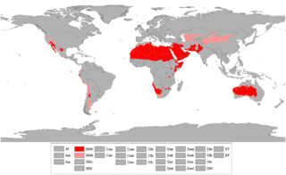
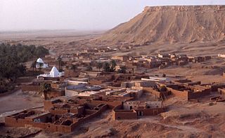
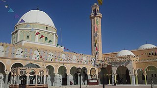
El Oued, Souf or Oued Souf is a city, and the capital of El Oued Province, in Algeria. The oasis town is watered by an underground river, hence its name is El Oued which enables date palm cultivation and the rare use of brick construction for housing. As most roofs are domed, it is known as the "City of a Thousand Domes".

El Goléa Commune and town in Ghardaïa Province, Algeria

El Goléa is an oasis town and commune, and capital of El Ménia District, in Ghardaïa Province, Algeria. The official name is El Ménia ; together in Arabic, the two names mean Impregnable Castle. According to the 2008 census it has a population of 40,195, up from 28,848 in 1998, with an annual growth rate of 3.4%. The area is inhabited by the Zenete Berbers. El Goléa oasis grows many agricultural products. The grave of the French priest Charles de Foucauld is located in the town.

Illizi city in Algeria

Illizi is a town and commune, coextensive with Illizi District, situated in the south-eastern part of Algeria, and capital of Illizi Province. According to the 2008 census it is the largest commune by population in the province, with a population of 17,252, up from 10,163 in 1998, and an annual population growth rate of 5.5%, the highest in the province. It is one of the gates to the Tassili N'Ajjer National Park with caves situated under the sands containing prehistoric drawings dating from 6000 years BC. There is a hotel and two camping sites, as well as many local tourist agencies.

In Ghar Commune and town in Tamanrasset, Algeria

In Ghar is a town and commune, coextensive with the district of In Ghar, in Tamanrasset Province, Algeria. According to the 2008 census it has a population of 11,225, up from 8,059 in 1998, with an annual growth rate of 3.4%. Its postal code is 11210 and its municipal code is 1103.

Aougrout Commune in Adrar, Algeria

Aougrout is a commune in Aougrout District, Adrar Province, in south-central Algeria. According to the 2008 census it has a population of 11,784, up from 9,878 in 1998, with an annual growth rate of 1.8%.

Tsabit Town and commune in Adrar, Algeria

Tsabit is a town and commune, and capital of Tsabit District, in Adrar Province, south-central Algeria. According to the 2008 census it has a population of 14,895, up from 11,832 in 1998, with an annual growth rate of 2.4%.

NGoussa Commune and town in Ouargla Province, Algeria

N'Goussa is a town and commune, coextensive with the district of the same name, in Ouargla Province, Algeria. Some of its inhabitants speak the Ouargli language. As of 2008, the population of the town was 19,039, up from 13,344 in 1998, with an annual population growth rate of 2.2%. The town is on a local road, about 20 kilometres (12 mi) north of Ouargla on the way to El Hadjira further north.

Djamaa Commune and town in El Oued Province, Algeria

Djamaa is a town and commune in El Oued Province, Algeria. According to the 2008 census it has a population of 50,916, up from 37,438 in 1998, with an annual growth rate of 3.1%.

Magrane, Algeria Commune and town in El Oued Province, Algeria

Magrane is a town and commune, and capital of Magrane District, in El Oued Province, Algeria. According to the 2008 census it has a population of 24,577, up from 20,102 in 1998, with an annual growth rate of 2.1%.

Nakhla, Algeria Commune and town in El Oued Province, Algeria

Nakhla is a town and commune in Robbah District, El Oued Province, Algeria. According to the 2008 census it has a population of 12,652, up from 9,491 in 1998, with an annual growth rate of 3.0%.

Ourmes Commune and town in El Oued Province, Algeria

Ourmes is a town and commune in Guemar District, El Oued Province, Algeria. According to the 2008 census it has a population of 5,900, up from 5,059 in 1998, with an annual growth rate of 1.6%. It is located 9 kilometres (5.6 mi) northwest of the provincial capital El Oued, and is connected by local roads to Kouinine and Taghzout.

Robbah Commune and town in El Oued Province, Algeria

Robbah is a town and commune, and capital of Robbah District, in El Oued Province, Algeria. According to the 2008 census it has a population of 21,965, up from 17,243 in 1998, and an annual growth rate of 2.5%. The town lies about 10 kilometres (6.2 mi) southeast of the provincial capital El Oued and forms a part of its larger urban area.

Sidi Khellil Commune and town in El Oued Province, Algeria

Sidi Khellil is a town and commune in El M'Ghair District, El Oued Province, Algeria. According to the 2008 census it has a population of 6,547, up from 5,524 in 1998, and an annual growth rate of 1.7%.

El Guerrara Commune and town in Ghardaïa Province, Algeria

El Guerrara is a town and commune, coextensive with El Guerrara District, in Ghardaïa Province, Algeria. According to the 2008 census it has a population of 59,514, up from 48,313 in 1998, with an annual growth rate of 2.1%.

Aïn Beida, Ouargla Commune and town in Ouargla Province, Algeria

Ain Beida is a town and commune in Sidi Khouïled District, Ouargla Province, Algeria. According to the 2008 census it has a population of 19,039, up from 14,500 in 1998, and an annual population growth rate of 2.8%. Ain Beida is just 6 kilometres (3.7 mi) from central Ouargla and is effectively a suburb of the city. It is also home to the Ain Beida Airport, Ouargla's principal airport.

Megarine Commune and town in Ouargla Province, Algeria

Megarine is a town and commune in Ouargla Province, Algeria, located just north of the city of Touggourt. According to the 2008 census it has a population of 13,751, up from 10,996 in 1998, and an annual growth rate of 2.3%.

MNaguer Commune and town in Ouargla Province, Algeria

M'Naguer is a town and commune in Taibet District, Ouargla Province, Algeria. According to the 2008 census it has a population of 14,179, up from 11,243 in 1998, and an annual population growth rate of 2.4%.

Sidi Slimane, Ouargla Commune and town in Ouargla Province, Algeria

Sidi Slimane is a town and commune in Mégarine District, Ouargla Province, Algeria, located near the city of Touggourt. According to the 2008 census it has a population of 8,072, up from 6,822 in 1998, and an annual growth rate of 1.7%.

Taibet Commune and town in Ouargla Province, Algeria

Taibet is a town and commune, and the capital of Taibet District, in Ouargla Province, Algeria. According to the 2008 census it has a population of 20,174, up from 14,322 in 1998, and a growth rate of 3.6%.

Tamacine Commune and town in Ouargla Province, Algeria

Tamacine is a town and commune, and capital of Témacine District, in Ouargla Province, Algeria. According to the 2008 census it has a population of 20,067, up from 15,933 in 1998, and an annual growth rate of 2.4%. It is around 10 kilometres (6.2 mi) south of Touggourt. The Tugurt language is spoken by some residents of Tamacine.

References

  1. 1 2 3 4 5 6 7 "Official website of the province of Ouargla - Balidat Ameur" (in Arabic). Archived from the original on 24 March 2013. Retrieved 25 February 2013.
  2. 1 2 3 "Population: Ouargla Wilaya" (PDF) (in French). Office National des Statistiques Algérie. Retrieved 24 February 2013.
  3. "Algeria Communes". Statoids. Retrieved 8 March 2013.
  4. "Structure relative de la population résidente des ménages ordinaires et collectifs âgée de 6 ans et plus selon le niveau d'instruction et la commune de résidence" (PDF) (in French). Office National des Statistiques Algérie. Retrieved 13 February 2013.
  5. "Taux d'analphabétisme et taux d'alphabétisation de la population âgée de 15 ans et plus, selon le sexe et la commune de résidence" (PDF) (in French). Office National des Statistiques Algérie. Retrieved 13 February 2013.
  6. "Décret n° 84-365, fixant la composition, la consistance et les limites territoriale des communes. Wilaya d'El Oued" (PDF) (in French). Journal officiel de la République Algérienne. 19 December 1984. p. 1551. Archived from the original (PDF) on 21 October 2013. Retrieved 2 March 2013.
Neighbouring towns and cities