Dnipropetrovsk Oblast, also referred to as Dnipropetrovshchyna, is an oblast (province) in southeastern Ukraine, the most important industrial region of the country. It was created on February 27, 1932. Dnipropetrovsk Oblast has a population of about 3,096,485, approximately 80% of whom live centering on administrative centers: Dnipro, Kryvyi Rih, Kamianske, Nikopol and Pavlohrad. The Dnieper River runs through the oblast.
Dnipro, formerly Dnipropetrovsk (1926–2016), is Ukraine's fourth-largest city, with about one million inhabitants. It is located in the eastern part of Ukraine, 391 km (243 mi) southeast of the Ukrainian capital Kyiv on the Dnieper River, after which its Ukrainian language name is derived. Dnipro is the administrative centre of Dnipropetrovsk Oblast. It hosts the administration of Dnipro urban hromada. Dnipro has a population of 968,502.

Pokrovsk Raion is a raion (district) within Donetsk Oblast in eastern Ukraine. Its administrative center is Pokrovsk. It has an area of 1,316 square kilometres (508 sq mi) and its population is approximately 386,451.
Nikopol Raion is a raion (district) of Dnipropetrovsk Oblast, Ukraine. Its administrative center is the city of Nikopol. Population: 250,746.

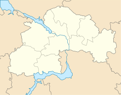
Dnipro Raion, formerly Dnipropetrovsk Raion until 2016, is a raion (district) of Dnipropetrovsk Oblast, southeastern Ukraine. Its administrative centre is the city of Dnipro. The population is 1,145,065.
Novomoskovsk Raion is a raion (district) of Dnipropetrovsk Oblast, southeastern-central Ukraine. Its administrative centre is located at Novomoskovsk. Population: 167,526.

Pavlohrad Raion is a raion (district) of Dnipropetrovsk Oblast, southeastern-central Ukraine. Its administrative centre is located at the city of Pavlohrad. Population: 166,797.
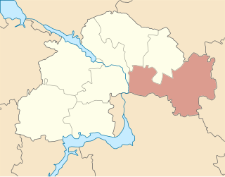
Synelnykove Raion is a raion (district) of Dnipropetrovsk Oblast, southeastern-central Ukraine. Its administrative centre is located at Synelnykove. Population: 198,974.

Chuhuiv Raion is a raion (district) in Kharkiv Oblast, Ukraine. Its administrative center is the city of Chuhuiv. Population: 194,177.
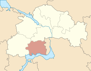
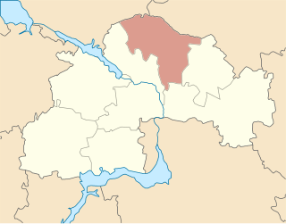
Dnipropetrovsk Oblast is subdivided into districts (raions) which are further subdivided into territorial communities (hromadas).
Obukhivka is an urban-type settlement in Dnipro Raion, Dnipropetrovsk Oblast, Ukraine. Until 2016, the settlement was known as Kirovske. It was renamed by the Verkhovna Rada according to the law prohibiting names of communist origin. Obukhivka is a suburb of Dnipro and is located on the left bank of the Dnieper. It hosts the administration of Obukhivka settlement hromada, one of the hromadas of Ukraine. Population: 9,137.
Slobozhanske is an urban-type settlement in Dnipro Raion, Dnipropetrovsk Oblast, Ukraine. The populated place is part of the Dnipro urban sprawl being its immediate northern suburb. Slobozhanske hosts the administration of Slobozhanske settlement hromada, one of the hromadas of Ukraine. Population: 14,661.
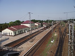
Chaplyne is an urban-type settlement in Synelnykove Raion, Dnipropetrovsk Oblast, Ukraine. It belongs to Dubovyky rural hromada, one of the hromadas of Ukraine. Its latest estimated population was 3,630.

Zarichchia is a village in Nadvirna Raion of Ivano-Frankivsk Oblast of Ukraine. It belongs to Deliatyn settlement hromada, one of the hromadas of Ukraine.
Bozhedarivka is an urban-type settlement in Kamianske Raion, Dnipropetrovsk Oblast, Ukraine. It is located approximately 50 kilometres (31 mi) west of Dnipro. From 1939 until February 2016 it was known as Shchorsk, in honor of Red Army commander Nikolay Shchors, but was renamed to comply with the Ukraine's law prohibiting names of Communist origin. Bozhedarivka hosts the administration of Bozhedarivka settlement hromada, one of the hromadas of Ukraine. Population: 2,651.

Slobozhanske settlement hromada is a territorial community in Ukraine, in Dnipro Raion of Dnipropetrovsk Oblast. The administrative center is the urban-type settlement of Slobozhanske. It was formed on August 14, 2015 by merging the Yuvileyne settlement council and the Stepove village council of Dnipropetrovsk Raion.
Olexandrivka is a village in Dnipro Raion Dnipropetrovsk Oblast Ukraine. The village is part of Slobozhanska settlement hromada.
Dnipro urban territorial hromada is one of the hromadas of Ukraine, located in Dnipro Raion within Dnipropetrovsk Oblast. Its capital is the city of Dnipro.
Kamianske urban territorial hromada located within Kamianske Raion in Dnipropetrovsk Oblast. Its administrative centre is the city of Kamianske.
Novhorod-Siverskyi urban territorial hromada is one of the hromadas of Ukraine, located in Novhorod-Siverskyi Raion within Chernihiv Oblast. Its capital is the city of Novhorod-Siverskyi.