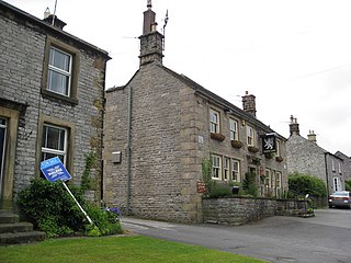
Ballidon Dale | |
---|---|
![]() | |
Length | c.2.5 kilometres (1.6 mi)North-South |
Width | c.400 metres (1,312 ft) |
Depth | c.100 metres (328 ft) |
Geography | |
Location | Derbyshire, England |
Coordinates | 53°05′17″N1°42′50″W / 53.08813°N 1.71396°W |
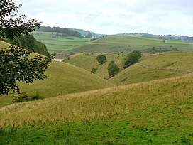
Ballidon Dale is a steep-sided, dry carboniferous limestone valley near Parwich in the Derbyshire Peak District of England. The ancient hamlet of Ballidon (mentioned in the Domesday Book [1] ) lies at the southern foot of the dale. Ballidon Quarry and Hoe Grange limestone quarries now dominate the west side of the dale. [2]
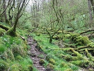
The fossil-rich limestone was formed from deposits in a warm shallow sea in the Brigantian stage of the Carboniferous period (around 330 million years ago). Ballidon Dale is a designated Site of Special Scientific Interest (SSSI). The protected SSSI area covers the main broad, deep valley as well as the long dale on the west side and smaller dale from the east side. There are early purple orchid in the main dale. There is a rich variety of grasses and herbs on the dale sides. Grasses include meadow oat, parnassus, quaking grass, sheep's fescue, glaucous sedge, carnation sedge and spring sedge. Herbs include salad burnet, bird's-foot trefoil, mouse ear hawkweed, scabious, fairy flax, thyme and lady's bedstraw. [3]
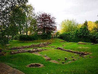
There are earthworks and buried remains of a medieval settlement at the southern end of Ballidon Dale. The Anglo-Saxon estate at Ballidon was granted by King Edgar in AD 963. Field boundaries and ridge and furrow farming features are still visible. The site is a protected Scheduled Monument. [4] The restored Anglo-Norman church on the site is a Grade II listed building. [5]
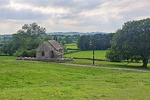
At the head of the dale are Roystone Grange farmhouse and barn, which are Grade II listed buildings from the 18th century. [6] The monastic grange dates from the Middle Ages, with remains of building platforms, a medieval field system and a dew pond from the Roman era lying 200m south of the present farmhouse building. The wool-producing grange was established by the Cistercian Garendon Abbey in Leicestershire in the 12th or 13th century, when the grange was recorded as 'Reevestones'. The site is a registered Scheduled Monument. [7] Nearby are a burial barrow where remains from the Bronze Age and Romano-British pottery and metalwork have been found. The barrow and the adjacent medieval animal pen are also a designated Scheduled Monument. [8] In the immediate surroundings are three further Scheduled Monuments of the remains of a Romano-British settlement and field system. There are remains of farmhouses, outbuildings, walled field enclosures, terraces and orthostats. Roman pottery artefacts and coins were discovered at the site. [9] [10] [11]
Ballidon Dale, and Roystone Rocks at its head, are designated as 'Open Access' land for the public, following the Countryside and Rights of Way Act 2000. [12] There is a track with public access along the length of the valley floor, with access into the dale from both ends. The Limestone Way long-distance footpath crosses the foot of the dale by the settlement of Ballidon. [2]
The history of Derbyshire can be traced back to human settlement since the last Ice Age, over 10,000 years ago. The county of Derbyshire in England dates back to the 11th century.
Lathkill Dale is the valley of the River Lathkill near Bakewell, Derbyshire in the Peak District of England. The river emerges into the dale from springs below Lathkill Head Cave. Towards the head of the dale is the side valley Cales Dale.
The Limestone Way is a waymarked long-distance footpath in Derbyshire, England. It runs for 46 miles (74 km) through the White Peak of the Peak District National Park, from Castleton south to Rocester over the county boundary into Staffordshire. The trail is named for the limestone scenery along its route. It was devised by Brian Spencer of Matlock Rotary Club and developed and opened in 1986 by the West Derbyshire District Council. It originally ran to Matlock, but was extended to its current, longer route in 1992 to join up with the Staffordshire Way.
Great Longstone with Little Longstone is one of two villages in the local government district of Derbyshire Dales in Derbyshire, England. The population as taken at the 2011 Census was 843.
Ballidon is a village and civil parish in the Derbyshire Dales district of Derbyshire, England, on the edge of the Peak District National Park. According to the 2001 census it had a population of 79. The population at the 2011 Census remained less than 100. Details are maintained in the civil Parish of Aldwark, Derbyshire.
Upton Lovell is a village and civil parish in Wiltshire, England. It lies on the A36, in the Wylye valley about 5 miles (8.0 km) southeast of Warminster. The parish is on the left (northeast) bank of the river, and stretches for over two miles northeast onto Salisbury Plain.
Winterbourne Stoke is a village and civil parish in Wiltshire, England, about 5 miles (8 km) west of Amesbury and 3 miles (4.8 km) west of the prehistoric monument of Stonehenge.
Mendip is a local government district of Somerset in England. The Mendip district covers a largely rural area of 285 square miles (738 km2) ranging from the Mendip Hills through on to the Somerset Levels. It has a population of approximately 110,000. The administrative centre of the district is Shepton Mallet but the largest town is Frome.
Benty Grange is a Site of Special Scientific Interest in the parish of Monyash in Derbyshire, England. 21.1 ha in size and with at least four species of grass and ten others of plant, it is considered of national importance as one of the largest areas of unimproved species-rich neutral lowland grassland in the Peak District National Park. The area was confirmed as a Site of Special Scientific Interest on 8 March 2013, following notification of the designation on 19 June 2012.
This is a list of scheduled monuments in the English county of Lancashire.
Monk's Dale is a short steep-sided dry gorge near Buxton, Derbyshire, in the Peak District of England. The dale is cut into a plateau of farmland and lies to the east of the village of Wormhill. The head of the valley leads into Peter Dale to the north. Miller's Dale is at the foot of the valley to the south.
Cressbrook Dale is a dry carboniferous limestone gorge near Bakewell, Derbyshire, in the Peak District of England. The dale is cut into a plateau of farmland and lies to the south east of the village of Litton. Cressbrook village is at the foot of the valley to the south.
Harboro' Rocks is a dolomitic limestone hill near the village of Brassington in the Derbyshire Peak District. The summit is 379 metres (1,243 ft) above sea level with views across to Carsington Water.
Long Dale is a carboniferous limestone valley near the village of Elton, Derbyshire, in the Peak District of England. The dale is cut into the plateau of Gratton Moor and Smerrill Moor and lies to the north of the hamlet of Pikehall, which is the venue of the annual Y Not Festival. Midway down the valley it turns sharply left and is known as Gratton Dale. Most of the valley is dry but Rowlow Brook flows down the lower part of Gratton Dale towards Dale End and onwards to become the River Bradford at Youlgreave.
Cales Dale is a short valley towards the head of Lathkill Dale near Monyash, Derbyshire in the Peak District of England.
This is a list of scheduled monuments in the district of Amber Valley in the English county of Derbyshire.
This is a list of scheduled monuments in the district of Derbyshire Dales in the English county of Derbyshire.
This is a list of scheduled monuments in the district of South Derbyshire in the English county of Derbyshire.
{{cite web}}
: CS1 maint: url-status (link)