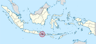
Bali is a province of Indonesia and the westernmost of the Lesser Sunda Islands. East of Java and west of Lombok, the province includes the island of Bali and a few smaller neighbouring islands, notably Nusa Penida, Nusa Lembongan, and Nusa Ceningan. The provincial capital, Denpasar, is the most populous city in the Lesser Sunda Islands and the second-largest, after Makassar, in Eastern Indonesia. Bali is the only Hindu-majority province in Indonesia, with 82.5% of the population adhering to Balinese Hinduism.

Ubud is a town on the Indonesian island of Bali in Ubud District, located amongst rice paddies and steep ravines in the central foothills of the Gianyar regency. Promoted as an arts and culture centre, it has developed a large tourism industry.

Mount Agung is an active volcano in Bali, Indonesia, southeast of Mount Batur volcano, also in Bali. It is the highest point on Bali, and dominates the surrounding area, influencing the climate, especially rainfall patterns. From a distance, the mountain appears to be perfectly conical. From the peak of the mountain, it is possible to see the peak of Mount Rinjani on the nearby island of Lombok, to the east, although both mountains are frequently covered in clouds. Agung is a stratovolcano, with a large and deep crater. Its most recent eruptions occurred from 2017–2019.

Indonesia is divided into provinces. Provinces are made up of regencies and cities. Provinces, regencies and cities have their own local governments and parliamentary bodies.
In Indonesia, village or subdistrict is the fourth-level subdivision below a district, regency/city, and province. There are a number of names and types for villages in Indonesia, with desa being the most frequently used for regencies and kelurahan for cities. According to the 2019 report by the Ministry of Home Affairs, there are 8,488 urban villages and 74,953 rural villages in Indonesia.

Buleleng is a regency (kabupaten) of Bali, Indonesia. It has an area of 1,365.88 km2 and population of 577,644 (1999). Its regency seat is Singaraja.
Tulamben is a small fishing village on the north-east coast of Bali. It is among the most popular dive sites on Bali since the wreck of the Liberty, a US Army Transport ship torpedoed by a Japanese submarine in 1942 lies just off shore. During high-season, up to 100 divers descend to the wreck each day.
Gelgel is a village (desa) in the regency (kabupaten) of Klungkung, on Bali, Indonesia. The village, near the coast four kilometers south of the regency capital Semarapura, contains a number of structures of cultural interest, and is known for its pottery and handwoven ceremonial songket cloth. The height of the village's power came during the kingdom of Gelgel, which dominated Bali from around the early 16th century to 1686. There are no traces left today of the old royal palace (puri). The old ancestral shrine of the ruling dynasti, Pura Jero Agung, is still standing in the old palace area. To the east of Pura Jero Agung is another old temple, Pura Dasar, which is a lowland counterpart of the "mother temple" of Bali, Pura Besakih. The village also contains the oldest mosque in Bali, which was built by Javanese retainers of the old kings.
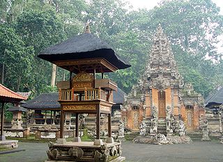
A pura is a Balinese Hindu temple, and the place of worship for adherents of Balinese Hinduism in Indonesia. Puras are built in accordance to rules, style, guidance and rituals found in Balinese architecture. Most puras are found on the island of Bali, where Hinduism is the predominant religion; however many puras exist in other parts of Indonesia where significant numbers of Balinese people reside. Mother Temple of Besakih is the most important, largest and holiest temple in Bali. Many puras have been built in Bali, leading it to be titled "the Island of a Thousand Puras".
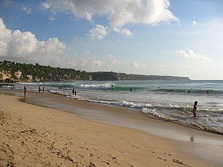
Pecatu is a region located in the southwestern peninsula of Bali, adjacent to the popular resort area of Nusa Dua that is located in the south-eastern end of the island. Pecatu is composed of hilly landscapes with limestone cliffs isolating small, short beaches. It also houses the renowned Uluwatu Temple that offers a spectacular performance of Kecak Dance with the Indian Ocean and magnificent sunset as its background. The area is popular for surfers and also nudists due to its location behind the cliffs with limited access.

Karangasem Regency is a regency (kabupaten) of Bali, Indonesia. It covers the east part of Bali, has an area of 839.54 km2 and a population of 369,320 (2002). Its regency seat is Amlapura. Karangasem was devastated when Mount Agung erupted in 1963, killing 1,900 people. Karangasem was a kingdom before Bali was conquered by the Dutch.
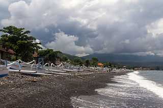
Amed is a 14-km strip of fishing villages in Karangasem Regency on the east coast of Bali, Indonesia. The area name Amed is taken from one of its seven villages. The other six are called Jemeluk, Bunutan, Lipah, Selang, Banyuning and Aas.

Telaga Waja is a river which is situated in eastern Bali, Indonesia. It rises on the slope of Mount Abang and passes through towns and wilderness slopes along the region of Rendang Village, reaching the sea in Klungkung Regency.
The 1979 Bali earthquake occurred at 03:58 local time on 18 December with a surface wave magnitude of 6.3. The shock occurred southeast of the coast of Karangasem Regency in the Lombok Strait, and about 60 kilometres (37 mi) east-northeast of Denpasar. Up to 80 percent of the buildings in Karangasem Regency were damaged, between 15,000 and 500,000 people were displaced, and road links to the provincial capital of Denpasar were briefly severed.

Mount Agung, a volcano on the island of Bali in Indonesia, erupted five times in late November 2017, causing thousands to evacuate, disrupting air travel and causing environmental damage. As of 27 November 2017, the alert level was at its highest and evacuation orders were in place.
Bebandem District is a village and sub-district in Karangasem Regency, Bali, Indonesia. The area is 81.51 km². In 2002, the population numbered 43,086 people.

I Wayan Koster is an Indonesian politician who is the 10th governor of Bali. Before becoming governor, he was a member of the People's Representative Council representing the province.

Penglipuran Village is one of the traditional villages located in Bangli Regency, Bali Province, Indonesia. Penglipuran village is famous as one of the tourist destinations in Bali because of its society who still preserve their traditional culture in their daily lives. The architecture of buildings and land processing still follows the concept of Tri Hita Karana, the philosophy of Balinese society regarding the balance of relations between God, humans and their environment. Penglipuran Village succeeded in building tourism that benefited all of their communities without losing their culture and traditions. In 1995, Penglipuran Village also received a Kalpataru award from the Indonesian Government for its efforts to protect the Bamboo Forest in their local ecosystem.
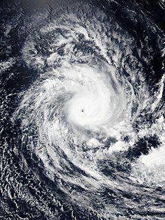
Cyclone Savannah was a strong tropical cyclone that brought significant impacts to Java and Bali and minor impacts to Christmas Island and the Cocos (Keeling) Islands during March 2019. It was the sixteenth tropical low, sixth tropical cyclone and third severe tropical cyclone of the 2018–19 Australian region cyclone season. Savannah developed from a tropical low that formed well to the east of Christmas Island on 8 March. The system was slow to develop initially, but reached tropical cyclone intensity on 13 March after adopting a southwesterly track. Savannah underwent rapid intensification and reached peak intensity on 17 March as a Category 4 severe tropical cyclone on the Australian scale. Ten-minute sustained winds were estimated as 175 km/h (110 mph), with a central barometric pressure of 951 hPa (28.08 inHg). One-minute sustained winds reached 185 km/h (115 mph) at this time, equivalent to a Category 3 major hurricane on the Saffir-Simpson hurricane wind scale. Weakening commenced soon afterwards, and responsibility for the system passed from the Australian Bureau of Meteorology to Météo-France. As it moved into the new region, Savannah became the eighth of a record-breaking ten intense tropical cyclones in the 2018–19 South-West Indian Ocean cyclone season. Savannah was downgraded to a tropical depression on 20 March, and its remnants dissipated in the central Indian Ocean on 24 March.