Related Research Articles

Borneo is the third-largest island in the world, with an area of 748,168 km2 (288,869 sq mi). Situated at the geographic centre of Maritime Southeast Asia, it is one of the Greater Sunda Islands, located north of Java, west of Sulawesi, and east of Sumatra.

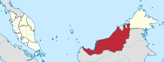
Sarawak is a state of Malaysia. The largest among the 13 states, with an area almost equal to that of Peninsular Malaysia, Sarawak is located in East Malaysia in northwest Borneo, and is bordered by the Malaysian state of Sabah to the northeast, Kalimantan to the south, and Brunei in the north. The state capital, Kuching, is the largest city in Sarawak, the economic centre of the state, and the seat of the Sarawak state government. Other cities and towns in Sarawak include Miri, Sibu, and Bintulu. As of the 2020 Malaysia census, the population of Sarawak was 2.453 million. Sarawak has an equatorial climate with tropical rainforests and abundant animal and plant species. It has several prominent cave systems at Gunung Mulu National Park. Rajang River is the longest river in Malaysia; Bakun Dam, one of the largest dams in Southeast Asia, is located on one of its tributaries, the Balui River. Mount Murud is the highest point in the state. Sarawak is the only state of Malaysia with a Christian majority.

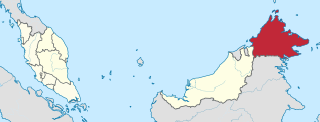
Sabah is a state of Malaysia located in northern Borneo, in the region of East Malaysia. Sabah has land borders with the Malaysian state of Sarawak to the southwest and Indonesia's North Kalimantan province to the south. The Federal Territory of Labuan is an island just off Sabah's west coast. Sabah shares maritime borders with Vietnam to the west and the Philippines to the north and east. Kota Kinabalu is the state capital and the economic centre of the state, and the seat of the Sabah State government. Other major towns in Sabah include Sandakan and Tawau. The 2020 census recorded a population of 3,418,785 in the state. It has an equatorial climate with tropical rainforests, abundant with animal and plant species. The state has long mountain ranges on the west side which forms part of the Crocker Range National Park. Kinabatangan River, the second longest river in Malaysia runs through Sabah. The highest point of Sabah, Mount Kinabalu is also the highest point of Malaysia.

East Malaysia, or the Borneo States, also known as Malaysian Borneo, is the part of Malaysia on and near the island of Borneo, the world's third-largest island. East Malaysia comprises the states of Sabah, Sarawak, and the Federal Territory of Labuan. The small independent nation of Brunei comprises two enclaves in Sarawak. To the south and southeast is the Indonesian portion of Borneo, Kalimantan. East Malaysia lies to the east of Peninsular Malaysia, the part of the country on the Malay Peninsula. The two are separated by the South China Sea.

Kuching, officially the City of Kuching, is the capital and the most populous city in the state of Sarawak in Malaysia. It is also the capital of Kuching Division. The city is on the Sarawak River at the southwest tip of Sarawak on the island of Borneo and covers an area of 431 km2 (166 sq mi) with a population about 165,642 in the Kuching North administrative region and 159,490 in the Kuching South administrative region—a total of 325,132 people.

The bay cat, also known as the Bornean bay cat, is a small wild cat endemic to the island of Borneo that appears to be relatively rare compared to sympatric wild cats, based on the paucity of historical, as well as recent records. Since 2002, it has been listed as Endangered on the IUCN Red List because it is estimated that fewer than 2,500 mature individuals exist, and that the population declined in the past. The bay cat has been recorded as rare and seems to occur at relatively low density, even in pristine habitats.

Sibu is a landlocked city located in the central region of Sarawak, Malaysia. It serves as the capital of Sibu District within Sibu Division and is situated on the island of Borneo. Covering an area of 129.5 square kilometres (50.0 sq mi), the city is positioned at the confluence of the Rajang and Igan Rivers, approximately 60 kilometres from the South China Sea and 191.5 kilometres (119 mi) north-east of the state capital, Kuching.

The Kelabit are an indigenous Dayak people of the Sarawak/North Kalimantan highlands of Borneo with a minority in the neighbouring state of Brunei. They have close ties to the Lun Bawang. The elevation there is slightly over 1,200 meters. In the past, because there were few roads and because the area was largely inaccessible by river because of rapids, the highlands and the Kelabit were relatively untouched by modern western influences. Now, however, there is a relatively permanent road route on which it is possible to reach Bario by car from Miri. The road is marked but driving without a local guide is not advisable, as it takes over 11 hours of driving to reach Bario from Miri through many logging trail junctions and river crossings.

The Rajang River is a river in Sarawak, northwestern Borneo, Malaysia. The river originates in the Iran Mountains, flows through Kapit, and then towards the South China Sea. At approximately 565 km long (351 mi), the river is the seventh-longest in Borneo and the longest in Malaysia.

The Borneo Post, established in 1978, is the largest and widely circulated English-language daily newspaper in East Malaysia and also the alternately circulated newspaper in Brunei. The newspaper is the first English newspaper in East Malaysia to use photo-composition for type-setting and printing was done in offset as against the old-fashioned letterpress.

Sarawak Stadium is a multi-purpose stadium in Kuching, Malaysia. It is currently used mostly for football matches. The stadium has a capacity of 40,000 spectators.

Bau is a gold mining town, capital of Bau district in the Kuching Division of Sarawak, Malaysia.
Balleh River is a river in Sarawak, Malaysia. It is a tributary of the Rajang River. In 1983 it was navigated by Redmond O'Hanlon and James Fenton. The journey is described in O'Hanlon's book, Into the Heart of Borneo.
The Maong River is a river in Sarawak, Malaysia. It is a tributary of the Sarawak River, joining it about half a kilometer from the city center of Kuching, the capital city of the state of Sarawak.
The Igan River is a river in Sarawak, Malaysia. It joins the Sungai Rajang in Sibu. The 95 km long river is still used as the primary route for travel to a number of rural districts in Sarawak.

The Baram River is a river in Sarawak on the island of Borneo. The river originates in the Kelabit Highlands, a watershed demarcated by the Iran Mountains of East Kalimantan, which form a natural border with Sarawak. The river flows westwards through tropical rainforest to the South China Sea. The Baram River terminates in a delta, which is subdivided into two units: East Barma Delta of Middle-Late Miocene age and West Baram Delta of Late Miocene-Quaternary age. The western unit is composed of mudstones enriched in organic components which constitute substantial oil and gas reserves.

Marudi is a town in the Malaysian state of Sarawak, and is a part of the division of Miri. It is the seat of Marudi District, and is located on the banks of Baram River, about 100 kilometres (62 mi) upstream from the river mouth. Marudi was the administrative centre of the northern region of Sarawak before Miri was established in 1910. Marudi is considered as the cultural heart of the Orang Ulu, the highland tribes of Sarawak. It is also a transit gateway to Kelabit Highlands and Gunung Mulu National Park, a UNESCO World Heritage Site.

The Brunei–Malaysia border divides the territories of Brunei and Malaysia on the island of Borneo. It consists of a 528.45 km (328.36 mi) land border and substantial lengths of maritime borders stretching from the coastline of the two countries to the edge of the continental shelf in the South China Sea.

Robert René Alberts is a Dutch professional football coach and former player.

The Fort Alice is a fort in Sri Aman, Sarawak, Malaysia.
References
- ↑ "Utusan Borneo – BorneoPost Online | Borneo , Malaysia, Sarawak Daily News | Largest English Daily In Borneo". Archived from the original on 2016-03-05.
1°40′24.2″N112°44′49.3″E / 1.673389°N 112.747028°E