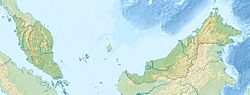
Brunei is a country in Southeast Asia, bordering the South China Sea and East Malaysia. Its geographical coordinates are 4°30′N114°40′E. The country is small with a total size of 5,765 km2 (2,226 sq mi). It is larger in size than Trinidad and Tobago. It is close to vital sea lanes through the South China Sea linking the Indian and Pacific Oceans. The country has two parts physically separated by Malaysia, making it almost an enclave within Malaysia.

Temburong District or simply known as Temburong, is the easternmost district in Brunei. It is an exclave surrounded by Malaysia and the Brunei Bay. Temburong is accessible from Brunei's mainland via the Sultan Haji Omar Ali Saifuddien Bridge. It has a total area of 1,306 km2 (504 sq mi). As of 2016, its population was 10,251; it is the least populous district in Brunei. Bangar is the administrative centre of the Temburong District.

Limbang is a border town and the capital of Limbang District in the Limbang Division of northern Sarawak, East Malaysia, on the island of Borneo. This district area is 3,978.10 square kilometres, and population was 56,900. It is located on the banks of the Limbang River, between the two halves of Brunei.
Nepenthes lowii, or Low's pitcher-plant, is a tropical pitcher plant endemic to Borneo. It is named after Hugh Low, who discovered it on Mount Kinabalu. This species is perhaps the most unusual in the genus, being characterised by its strongly constricted upper pitchers, which bear a greatly reduced peristome and a reflexed lid with numerous bristles on its lower surface.

Bukit Larut is a hill resort in Malaysia located in the state of Perak, Malaysia, 10 kilometres southwest from Taiping. It was established under the direction of British colonists in 1884 as a place of observation for tin mining activity and as a retreat for the English people who were based in nearby Larut and Taiping. The area was initially named Maxwell Hill after the British Malaya administrator George Maxwell, and was renamed as Bukit Larut in 1979.

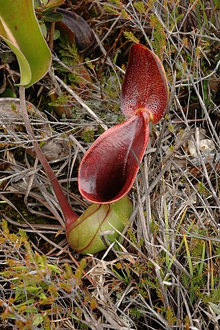
Nepenthes pilosa is a tropical pitcher plant endemic to Borneo. It is characterised by a dense indumentum of long yellow-brown hairs. Pitchers have a distinctive hook-shaped appendage on the underside of the lid. The specific epithet derives from the Latin word pilosus, meaning "hairy".
The mass media in Brunei are strictly controlled by the government under Sultan Hassanal Bolkiah, which has effectively imposed martial law in the country since the Brunei Revolt of 1962. News coverage consists of police-beat reporting, lifestyle features, and community events, with little in the way of diverse viewpoints. Reporters Without Borders reports there is "virtually no criticism of the government". The liberal democracy watchdog Freedom House lists Brunei's media as "not free".
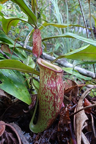
Nepenthes × kuchingensis is a natural hybrid between N. ampullaria and N. mirabilis. Although it is named after the city of Kuching in Sarawak, this plant has a wide distribution across Borneo, New Guinea, Peninsular Malaysia, Sumatra, and Thailand.
Bukit, the Indonesian or Malay word for hill, may refer to:

The Lambir Hills National Park is a national park in Miri Division, Sarawak, Malaysia, on the island of Borneo. It is a small park, at 6,952 hectares, and is composed largely of mixed dipterocarp forest, with some small areas of 'kerangas'. The park is 150–465 m (492–1,526 ft) above sea level.

The following outline is provided as an overview of and a topical guide to Brunei:

The Borneo lowland rain forests is an ecoregion, within the tropical and subtropical moist broadleaf forests biome, of the large island of Borneo in Southeast Asia. It supports approximately 15,000 plant species, 380 bird species and several mammal species. The Borneo lowland rain forests is diminishing due to logging, hunting and conversion to commercial land use.
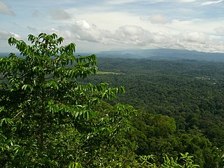
Peradayan Forest Reserve is a 2,650 hectares (10.2 sq mi) nature reserve in Mukim Batu Apoi, Temburong District, Brunei. It is located about 15 km (9.3 mi) from Bangar town.

The Borneo montane rain forests is an ecoregion on the island of Borneo in Southeast Asia. It includes montane tropical and subtropical moist broadleaf forests, also known as a cloud forests. The ecoregion is partly in East Malaysia and Indonesia (Kalimantan).
The Heart of Borneo is a conservation agreement initiated by the World Wide Fund for Nature to protect a 220,000 km² forested region on Borneo island. The agreement was signed by the governments of Brunei, Indonesia and Malaysia in Bali on 12 February 2007 to support the initiative. The region provides habitat to 10 endemic species of primates, more than 350 birds, 150 reptiles and amphibians and 10,000 plants. From 2007 to 2010 a total of 123 new species have been recorded in the region. A status report from 2012 found that the lowland rain forest within the area is deteriorating and under threat. The Bornean rhinoceros was the most threatened fauna, in 2015 three captive individuals remained in Sabah.

The Institute for Biodiversity and Environmental Research in Brunei Darussalam is a research institute of Universiti Brunei Darussalam (UBD) dedicated to biodiversity and environmental sciences research and education. IBER's location within the northwest Borneo hotspot offers unique opportunities for long-term studies in both terrestrial and marine tropical ecosystems.

Protected areas of Brunei are established by the Government of Brunei, in accordance with national development objectives and global biogeoecological strategies in which forests play an important role. The country's marine protected areas remained at 0.2% in 2022. As of 2011, nearly half of Brunei Darussalam is still primary forest, however this coverage is dwindling and only 17% of the country is officially protected.

Kampong Bukit Panggal is a village in Tutong District, Brunei, about 10 kilometres (6.2 mi) from the district town Pekan Tutong. The population was 801 in 2016. It is one of the villages within Mukim Keriam, a mukim in the district.
Retak Hill, is one of the major hills shared between Mukim Amo, Temburong District of Brunei and Limbang Division, Sarawak of Malaysia.
Tudal Hill, is one of the major hills shared between Mukim Amo, Temburong District of Brunei and Limbang Division, Sarawak of Malaysia.