Related Research Articles

Brunei, formally Brunei Darussalam, is a country located on the north coast of the island of Borneo in Southeast Asia. Apart from its South China Sea coast, it is completely surrounded by the Malaysian state of Sarawak. It is separated into two parts by the Sarawak district of Limbang. Brunei is the only sovereign state entirely on Borneo; the remainder of the island is divided between Malaysia and Indonesia. As of 2020, its population was 460,345, of whom about 100,000 live in the capital and largest city, Bandar Seri Begawan. The government is an absolute monarchy ruled by its Sultan, entitled the Yang di-Pertuan, and implements a combination of English common law and sharia law, as well as general Islamic practices.

Brunei is a country in Southeast Asia, bordering the South China Sea and East Malaysia. Its geographical coordinates are 4°30′N114°40′E. The country is small with a total size of 5,765 km2 (2,226 sq mi). It is larger in size than Trinidad and Tobago. It is close to vital sea lanes through the South China Sea linking the Indian and Pacific Oceans. The country has two parts physically separated by Malaysia, making it almost an enclave within Malaysia.

Borneo is the third-largest island in the world and the largest in Asia. At the geographic centre of Maritime Southeast Asia, in relation to major Indonesian islands, it is located north of Java, west of Sulawesi, and east of Sumatra.

Southeast Asia, also spelled South East Asia and South-East Asia, and also known as Southeastern Asia, South-eastern Asia or SEA, is the geographical south-eastern region of Asia, consisting of the regions that are situated south of mainland China, east of the Indian subcontinent, and north-west of mainland Australia which is part of Oceania. Southeast Asia is bordered to the north by East Asia, to the west by South Asia and the Bay of Bengal, to the east by Oceania and the Pacific Ocean, and to the south by Australia and the Indian Ocean. Apart from the British Indian Ocean Territory and two out of 26 atolls of Maldives in South Asia, Maritime Southeast Asia is the only other subregion of Asia that lies partly within the Southern Hemisphere. Mainland Southeast Asia is completely in the Northern Hemisphere. Timor-Leste and the southern portion of Indonesia are the only parts in Southeast Asia that are south of the Equator.

East Malaysia, or the Borneo States, also known as Malaysian Borneo, is the part of Malaysia on and near the island of Borneo, the world's third-largest island. Near the coast of Sabah is a small archipelago called Labuan. East Malaysia lies to the east of Peninsular Malaysia, the part of the country on the Malay Peninsula. The two are separated by the South China Sea.
The history of Brunei concerns the settlements and societies located on the north coast of the island of Borneo, which has been under the influence of Indianised kingdoms and empires for much of its history. Local scholars assume that the Islamisation of Brunei started in the fifteenth century, with the formation of the Bruneian Empire, a thalassocracy which covered the northern part of Borneo and the southern Philippines. At the end of the 17th century, Brunei subsequently entered a period of decline brought on by Brunei Civil War, piracy, and European colonial expansion. Later, there was a brief war with Spain, in which Brunei lost Manila and evacuated their capital for a brief period until the Spanish withdrew. The empire lost much of its territory with the arrival of the Western powers, such as the Spanish in the Philippines and the British in Labuan, Sarawak, and North Borneo. The decline of the Bruneian Empire accelerated in the nineteenth century when Brunei gave much of its territory to the White Rajahs of Sarawak, resulting in its current small landmass and separation into two parts. Sultan Hashim Jalilul Alam Aqamaddin later appealed to the British to stop further annexation in 1888. In the same year, the British signed a "Treaty of Protection" and made Brunei a British protectorate until 1984 when it gained independence and prospered due to the discovery of oil.
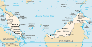
The geography of Malaysia includes both the physical and the human geography of Malaysia, a Southeast Asian country made up of two major landmasses separated by water—Peninsular Malaysia to the west and East Malaysia to the east—and numerous smaller islands that surround those landmasses. Peninsular Malaysia is on the southernmost part of the Malay Peninsula, south of Thailand, north of Singapore and east of the Indonesian island of Sumatra; East Malaysia comprises most of the northern part of Borneo island, and shares land borders with Brunei to the north and Indonesian Borneo to the south.

Malay is an Austronesian language that is an official language of Brunei, Indonesia, Malaysia, and Singapore, and that is also spoken in East Timor and parts of the Philippines and Thailand. Altogether, it is spoken by 290 million people across Maritime Southeast Asia.
The Indonesia–Malaysia confrontation or Borneo confrontation was an armed conflict from 1963 to 1966 that stemmed from Indonesia's opposition to the creation of state of Malaysia from the Federation of Malaya. After Indonesian president Sukarno was deposed in 1966, the dispute ended peacefully and the nation of Malaysia was formed.

Brunei Bay is on the northwestern coast of Borneo island, in Brunei and Malaysia.

Nepenthes reinwardtiana is a tropical pitcher plant native to Borneo and Sumatra and to a number of smaller surrounding islands including Bangka, Natuna, Nias, and Siberut. Although some sources have included Peninsular Malaysia and Singapore within the range of this species, these records appear to be erroneous.

Nepenthes × hookeriana, or Hooker's pitcher-plant, is a common natural hybrid involving N. ampullaria and N. rafflesiana. It was originally described as a species.

The Baram River is a river in Sarawak on the island of Borneo. The river originates in the Kelabit Highlands, a watershed demarcated by the Iran Mountains of East Kalimantan, which form a natural border with Sarawak. The river flows westwards through tropical rainforest to the South China Sea. The Baram River terminates in a delta, which is subdivided into two units: East Barma Delta of Middle-Late Miocene age and West Baram Delta of Late Miocene-Quaternary age. The western unit is composed of mudstones enriched in organic components which constitute substantial oil and gas reserves.

The Langkawi Cable Car, also known as Langkawi SkyCab, is a gondola lift and one of the major attractions in Langkawi Island, Kedah, Malaysia. It provides an aerial link from the Oriental Village at Teluk Burau to the peak of Gunung Machinchang, which is also the location of the Langkawi Sky Bridge. The total length is 2.2 km (1.4 mi), with a journey time from the base to the top of around 15 minutes. It was officially opened in 2003.

The Brunei–Malaysia border divides the territory of Brunei and Malaysia on the island of Borneo. It consists of a 266 km (165 mi) land border and substantial lengths of maritime borders stretching from the coastline of the two countries to the edge of the continental shelf in the South China Sea.
Lio Matoh is a remote Kenyah Badeng longhouse settlement in the mountainous interior of the Marudi division of Sarawak, Malaysia, not far from the border with Indonesia. It lies approximately 572.6 kilometres (356 mi) east-north-east of the state capital Kuching.
This article explains the phonology of Malay and Indonesian based on the pronunciation of Standard Malay, which is the official language of Brunei, Singapore and Malaysia, and Indonesian, which is the official language of Indonesia and a working language in Timor Leste. There are two main standards for Malay pronunciation, the Johor-Riau standard, used in Brunei and Malaysia, and the Baku, used in Indonesia and Singapore.
The Iran Mountains are a range of mountains on the island of Borneo. The mountains are on the border between Indonesia and Malaysia.
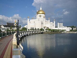
Tourism in Brunei is governed by the Ministry of Primary Resources and Tourism, which is planning to diversify Brunei's tourism to include adventure tourism, ecotourism and Islamic tourism.

The Serasa Ferry Terminal, also known as Serasa Muara Terminal and Serasa Terminal, is a passenger terminal operated by the Department of Immigration and National Registration in Mukim Serasa, Brunei-Muara District, Brunei. It is one of the two ferry terminals in Brunei, which is located in Kuala Belait Port and Serasa.