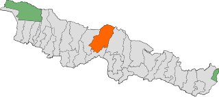
Sarlahi, a part of Madhesh Province, is one of the seventy-seven districts of Nepal. According to new laws, a combination of more than two or four villages makes a municipality, which covers an area of 1,259 km2 (486 sq mi) and had a population of 635,701 in 2001 and 769,729 in 2011.

Malangwa is a town, a municipality, and the headquarters of Sarlahi District in Province No. 2 of Nepal. The district's oldest municipality, it is in parliamentary constituency 2. From the Mahendra Highway 25 kilometres (16 mi) south of Nawalpur, a small highway side town. Situated at an altitude of 79 meters (259 ft), Malangwa is near the Indian border at Sonbarsa. There is a customs checkpoint at the border crossing.

Bardibas is a municipal area (municipality) and a town located in Mahottari District of Madhesh Province of Nepal. It is located at latitude: 26°54'6.84" to 27°08'46.90" and longitude: 85°47'42.67" to 85°56'42.97". The municipality is surrounded by Dhanusha District in the East and Sarlahi District in the West, Bagmati Province falls in the North and Bhangaha, Aurahi and Gaushala municipalities are located in the South.
Balara (Maithili/Nepali: बलरा) is a municipality in Sarlahi District, a part of Madhesh Province in Nepal. It was formed in 2016 occupying current 12 sections (wards) from previous 9 former VDCs. It occupies an area of 48.55 km2 with a total population of 45,194.
Godaita is a municipality in Sarlahi District, a part of Province No. 2 in Nepal. It was formed in 2016 occupying current 12 sections (wards) from previous 12 former VDCs. It occupies an area of 48.62 km2 with a total population of 42,315.
Haripurwa is a Municipality in Sarlahi District in the Janakpur Zone of south-eastern Nepal. At the time of the 2011 Nepal census it had a population of 15,798 people living in 2,593 individual households. it is made by the combination of villages like basantpur, haripurba,mirchaiya,zingarwa.
Hariwan Municipality is one of the new municipalities declared by the Government of Nepal on May 18, 2014. It is located in Sarlahi District Janakpur zone, Nepal. It is formed by the joining of four contemporary Village development committees (VDCs) namely Atrouli, Sasapur, Ghurkauli and Harion VDCs covering an area of 88.1 km2. It has been divided into 11 wards with an administration center in Harion Bazar. According to Nepal Population Census 2011, the municipality has a total population of 42,783.
Ishworpur is a Municipality in Sarlahi District in the Janakpur Zone of south-eastern Nepal. The municipality was established on 18 May 2014 by merging the existing Bela, Bhaktipur, Gaurishankar and Ishwarpur VDCs. At the time of the 1991 Nepal census it had a population of 14,014 people living in 249 individual households.
Kabilasi is a Village Development Committee in Sarlahi District in the Janakpur Zone of south-eastern Nepal. At the time of the 1991 Nepal census it had a population of 7,050 people residing in 1,362 individual households.
Lalbandi is a Municipality in Sarlahi District in the Janakpur Zone of Central Development Region of Nepal. The municipality was established on 18 May 2014 by merging the existing Parwanipur VDC, Netragung vdc, Jabdi, Lalbandi and Pattharkot VDCs. At the time of the 2021 Nepal Census, it had a population of 67,507 living in 13905 individual households. There are 17 wards in this municipality. It is the largest municipality in Sarlahi district. The office of this municipality is in ward no.6 Located in the Lalbandi. Lalbandi Bazar, located on the East West Mahendra highway, is one of the main trading areas within the municipal area. Bordering East Ishwarpur Municipality, West Hariwan and Haripur Municipality, North Sindhuli District and bordering Haripur and Ishwarpur in the south, Lalbandi Bazar is the main trading site of the district.
Parsa is a rural municipality in Sarlahi District, a part of Province No. 2 in Nepal. It is situated 10 km East from Malangwa which is headquarter of Sarlahi. It was formed in 2016 occupying current 6 sections (wards) from previous 6 former VDCs. It occupies an area of 23.12 km2 with a total population of 21,650. The major language spoken in the rural municipality are Maithili and Bajjika.
Ramnagar is a rural municipality in Sarlahi District, a part of Province No. 2 in Nepal. It was formed in 2016 occupying current 7 sections (wards) from previous 7 former VDCs. It occupies an area of 26.44 km2 with a total population of 40,128. Mayor Raja Babu yadav Deputy mayor Gita devi

Barahathwa is a municipality of the Sarlahi District in the Janakpur Zone of central Nepal. The municipality was established on 19 September 2015 by merging the existing Barahathwa, Murtiya, Hajariya and Laukat village development committees (VDCs). The center of the municipality is established in the former VDC Office of Barahathwa Bazaar. After merging the four VDCs' populations, it had a total population of 50,424 according to 2011 Nepal census. After the government decision, the number of Nepali municipalities reached 217.
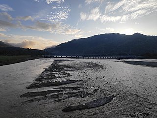
Gadhimai is a municipality in Rautahat district of Narayani zone, Nepal. It lies at the border of Rautahat district that links Sarlahi District over Bagmati River. It was formed by merging former 6 Village development committees Gamhariya, samanpur, Sangrampur, Bahuwa Madanpur, Dharampur and Bariyarpur just before 2017 Nepalese local elections.
Sarlahi 1 is one of four parliamentary constituencies of Sarlahi District in Nepal. This constituency came into existence on the Constituency Delimitation Commission (CDC) report submitted on 31 August 2017.

Sarlahi 2 is one of four parliamentary constituencies of Sarlahi District in Nepal. This constituency came into existence on the Constituency Delimitation Commission (CDC) report submitted on 31 August 2017.

Sarlahi 3 is one of four parliamentary constituencies of Sarlahi District in Nepal. This constituency came into existence on the Constituency Delimitation Commission (CDC) report submitted on 31 August 2017.

Sarlahi 4 is one of four parliamentary constituencies of Sarlahi District in Nepal. This constituency came into existence on the Constituency Delimitation Commission (CDC) report submitted on 31 August 2017.


