Bargischow

Last updated
Bargischow
BargischowKirche.jpg
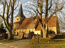
Medieval village church in Bargischow
Location of Bargischow within Vorpommern-Greifswald district
Bargischow in VG.svg
Germany adm location map.svg
Red pog.svg
Bargischow
Mecklenburg-Vorpommern location map.svg
Red pog.svg
Bargischow
Coordinates: 53°50′N13°45′E / 53.833°N 13.750°E / 53.833; 13.750
Country Germany
State Mecklenburg-Vorpommern
District Vorpommern-Greifswald
Municipal assoc. Anklam-Land
Subdivisions4 Ortsteile
Government
   Mayor André Stegemann
Area
  Total21.70 km2 (8.38 sq mi)
Elevation
4 m (13 ft)
Population
 (2021-12-31) [1]
  Total286
  Density13/km2 (34/sq mi)
Time zone UTC+01:00 (CET)
  Summer (DST) UTC+02:00 (CEST)
Postal codes
17398
Dialling codes 03971
Vehicle registration VG
Website www.amt-anklam-land.de

Bargischow is a municipality in the Vorpommern-Greifswald district, in Mecklenburg-Vorpommern, Germany.

Contents

History

From 1653 to 1815, Bargischow was part of Swedish Pomerania. From 1815 to 1945, it was part of the Prussian Province of Pomerania, from 1945 to 1952 of the State of Mecklenburg-Vorpommern, from 1952 to 1990 of the Bezirk Neubrandenburg of East Germany and since 1990 again of Mecklenburg-Vorpommern.

Location

The railway route between Berlin and Stralsund crosses between the municipality and Woserow.

Geography and transport

Location

The municipality of Bargischow lies about 5 kilometres east of the Hanseatic town of Anklam. To the west the municipality borders immediately on the borough of Anklam. To the north, the Peene, which empties into the Peenestrom, forms the boundary. To the east, the municipality's peninsula of Anklamer Fähre borders on the Stettin Lagoon, which unites with the Peenestrom in the northeast. To the southeast is the Anklamer Torfmoor. The municipality of Bugewitz borders in the southeast on Neu Kosenow and in the south on Bargischow.

Transport

The Berlin–Stralsund line crosses the municipal area between Bargischow and Woserow, whilst the B 109 federal road passes west of Woserow.

Related Research Articles

<span class="mw-page-title-main">Pomerania</span> Historical region on the southern shore of the Baltic Sea in Central Europe

Pomerania is a historical region on the southern shore of the Baltic Sea in Central Europe, split between Poland and Germany. The western part of Pomerania belongs to the German states of Mecklenburg-Western Pomerania and Brandenburg, while the eastern part belongs to the West Pomeranian, Pomeranian and Kuyavian-Pomeranian voivodeships of Poland.

<span class="mw-page-title-main">Mecklenburg-Vorpommern</span> State in Germany

Mecklenburg-Vorpommern, also known by its anglicized name Mecklenburg–Western Pomerania, is a state in the north-east of Germany. Of the country's sixteen states, Mecklenburg-Vorpommern ranks 14th in population; it covers an area of 23,213 km2 (8,963 sq mi), making it the sixth largest German state in area; and it is 16th in population density. Schwerin is the state capital and Rostock is the largest city. Other major cities include Neubrandenburg, Stralsund, Greifswald, Wismar, and Güstrow. It was named after the two regions of Mecklenburg and Vorpommern, and its name means the "nearer part of Pomerania", with the rest now lying in Poland.

<span class="mw-page-title-main">Greifswald</span> City in Mecklenburg-Vorpommern, Germany

Greifswald, officially the University and Hanseatic City of Greifswald is the fourth-largest city in the German state of Mecklenburg-Western Pomerania after Rostock, Schwerin and Neubrandenburg. In 2021 it surpassed Stralsund for the first time, and became the largest city in the Pomeranian part of the state. It sits on the River Ryck, at its mouth into the Danish Wiek, a sub-bay of the Bay of Greifswald, which is itself a sub-bay of the Bay of Pomerania of the Baltic Sea.

<span class="mw-page-title-main">Anklam</span> Town in Mecklenburg-Vorpommern, Germany

Anklam is a town in the Western Pomerania region of Mecklenburg-Vorpommern, Germany. It is situated on the banks of the Peene river, just 8 km from its mouth in the Kleines Haff, the western part of the Stettin Lagoon. Anklam has a population of 12,177 (2021) and was the capital of the former Ostvorpommern district. Since September 2011, it has been part of the district of Vorpommern-Greifswald.

<span class="mw-page-title-main">Swedish Pomerania</span> Sweden-held lands on the southern Baltic coast (1630–1815)

Swedish Pomerania was a dominion under the Swedish Crown from 1630 to 1815 on what is now the Baltic coast of Germany and Poland. Following the Polish War and the Thirty Years' War, Sweden held extensive control over the lands on the southern Baltic coast, including Pomerania and parts of Livonia and Prussia.

<span class="mw-page-title-main">Mecklenburgisch-Vorpommersch dialect</span> Low German dialect

Mecklenburgisch-Vorpommersch is a Low German dialect spoken in the German state of Mecklenburg-Vorpommern. It belongs to the East Low German group.

<span class="mw-page-title-main">Usedom (town)</span> Town in Mecklenburg-Vorpommern, Germany

Usedom is a town on Usedom Island, in the Vorpommern-Greifswald district in Mecklenburg-Vorpommern, Germany. It is the seat of the Amt Usedom-Süd, to which 14 other communities also belong.

<span class="mw-page-title-main">Grimmen</span> Town in Mecklenburg-Vorpommern, Germany

Grimmen is a town in Vorpommern-Rügen, a district in the Bundesland Mecklenburg-Vorpommern, Germany. Prior to 2011, when district reforms were made in Mecklenburg-Vorpommern, it was the capital of the now bygone Nordvorpommern district, which was abolished and merged to create the district of Vorpommern-Rügen.

<span class="mw-page-title-main">Jarmen</span> Town in Mecklenburg-Vorpommern, Germany

Jarmen is a town in the Vorpommern-Greifswald district, in Mecklenburg-Western Pomerania, Germany. It is situated on the southern bank of the river Peene, 20 km south of Greifswald, in the historic region of Pomerania.

<span class="mw-page-title-main">Lassan, Germany</span> Town in Mecklenburg-Vorpommern, Germany

Lassan is a town in the Vorpommern-Greifswald district, in Mecklenburg-Western Pomerania, Germany.

Reinberg is a village and in the municipality of Sundhagen and lies between Stralsund and Greifswald on the B 105 federal road in northeastern Germany. To the north the former municipality of Reinberg borders on the Strelasund From the village of Stahlbrode that used to belong to it, there is a car ferry to the island of Rügen.

<span class="mw-page-title-main">Neu Kosenow</span> Municipality in Mecklenburg-Vorpommern, Germany

Neu Kosenow is a municipality in the Vorpommern-Greifswald district, in Mecklenburg-Vorpommern, Germany. It has a total area of 24.89 km sq with a population of 470.

<span class="mw-page-title-main">Bugewitz</span> Municipality in Mecklenburg-Vorpommern, Germany

Bugewitz is a municipality in the Vorpommern-Greifswald district, in Mecklenburg-Vorpommern in north-eastern Germany. It is the least densely populated municipality in what was East Germany, and the fifth-least densely populated in all of Germany. All four municipalities of lesser population density are located in Schleswig-Holstein.

<span class="mw-page-title-main">Boldekow</span> Municipality in Mecklenburg-Vorpommern, Germany

Boldekow is a municipality in the Vorpommern-Greifswald district, in Mecklenburg-Vorpommern, Germany.

<span class="mw-page-title-main">Blesewitz</span> Place in Mecklenburg-Vorpommern, Germany

Blesewitz is a municipality in the Vorpommern-Greifswald district, in Mecklenburg-Vorpommern, Germany.

<span class="mw-page-title-main">Zirkow</span> Municipality in Mecklenburg-Vorpommern, Germany

Zirkow is a municipality on the German Baltic Sea island of Rügen in the county of Vorpommern-Rügen in the state of Mecklenburg-Western Pomerania.

<span class="mw-page-title-main">History of Pomerania (1945–present)</span>

History of Pomerania (1945–present) covers the history of Pomerania during World War II aftermath, the Communist and since 1989 Democratic era.

<span class="mw-page-title-main">Angermünde–Stralsund railway</span>

The Angermünde–Stralsund railway is a major railway in the north-eastern German states of Brandenburg and Mecklenburg-Vorpommern, which is part of the long-distance line from Berlin to Rügen. The line is one of the oldest lines in Western Pomerania and was built and operated by the Berlin-Stettin Railway Company from 1863.

<span class="mw-page-title-main">Stralsund (region)</span>

The Region of Stralsund belonged to the Prussian Province of Pomerania and existed from 1818 to 1932.

<span class="mw-page-title-main">Western Pomerania</span> Historical region in present-day northeast Germany

Historical Western Pomerania, also called Cispomerania,Fore Pomerania, Front Pomerania or Hither Pomerania, is the western extremity of the historic region of Pomerania forming the southern coast of the Baltic Sea. Western Pomerania's boundaries have changed through the centuries as it belonged to various countries such as Poland, the Duchy of Pomerania, Sweden, Denmark, as well as Prussia which incorporated it as the Province of Pomerania.

References

  1. "Bevölkerungsstand der Kreise, Ämter und Gemeinden 2021" (XLS) (in German). Statistisches Amt Mecklenburg-Vorpommern. 2022.